0 Georgia Ave Unit 20251028141 Port Huron, MI 48060
Estimated payment $32/month
About This Lot
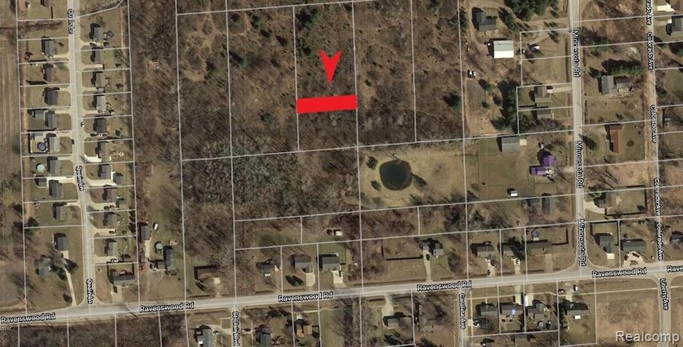
Parcel is North of Ravenswood Road, and between Quain Lane and Minnesota Road. BTVAI.
Property Details
Property Type
- Land
Est. Annual Taxes
Lot Details
- 5,663 Sq Ft Lot
- Lot Dimensions are 40.00x138.40
- Property fronts a private road
Community Details
- St Clair Boulevard Sub Subdivision
Listing and Financial Details
- Assessor Parcel Number 74287420034000
Map
Home Values in the Area
Average Home Value in this Area
Property History
| Date | Event | Price | List to Sale | Price per Sq Ft |
|---|---|---|---|---|
| 08/18/2025 08/18/25 | For Sale | $5,000 | -- | -- |
Source: Realcomp
MLS Number: 20251028141
Disclaimer: Certain information contained herein is derived from information provided by parties other than Homes.com. All information provided is deemed reliable, but is not guaranteed to be accurate and should be independently verified.
![]() IDX provided courtesy of Realcomp II Ltd. via Ten-X and MLS
IDX provided courtesy of Realcomp II Ltd. via Ten-X and MLS
Copyright 2025 Realcomp II Ltd. Shareholders
IDX information is provided exclusively for consumers' personal, noncommercial use and may not be used for any purpose other than to identify prospective properties consumers may be interested in purchasing. The accuracy of all information, regardless of source, is not guaranteed or warranted. All information should be independently verified.
Listing Information presented by local MLS brokerage: Ten-X, local REALTOR®- Arlene Richardson - (888)-952-6393
- 711 Georgia Ave
- 929 Georgia Ave
- 917 Carolina
- 0 Gratiot Blvd Unit 50105825
- 765 Lomasney Ln
- 1320 Georgia Ave
- 1337 Carolina
- 000 Montana Ave
- 808 5th St
- 250 Oregon Ave
- 1329 Vermont Ave
- 720 Arlington Cir
- 4601 Gratiot Rd
- 1066 Virginia Ave
- 277 Liberty Ave
- 4745 Smiths Creek Rd
- 260 Capitol Dr
- 192 Pickford Rd
- 105 Joan Ct
- 183 Nevada Ave
- 3991 Brookstone Place
- 1210-1470 Aspen Dr
- 2060 Parkdale Dr
- 3345 Military St
- 2900 Golden Crest Ct
- 2312 12th St
- 2455 Military St Unit 5
- 1104 Minnie St
- 1817 River Rd
- 2008 Military St Unit 16
- 1970 River Rd
- 1805 Military St
- 325 Court St Unit 1898 Lofts Loft No. 3
- 1104 4th St
- 2960-2968 Beach Rd
- 936 Brown St
- 1422 Lyon St Unit C
- 575 N Riverside Ave
- 106 S Carney Dr
- 2210 Willow St
