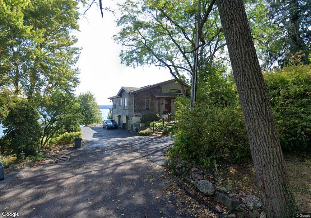
1 Clinton Ave Nyack, NY 10960
South Nyack NeighborhoodEstimated Value: $1,586,000 - $2,339,000
2
Beds
3
Baths
2,530
Sq Ft
$729/Sq Ft
Est. Value
About This Home
This home is located at 1 Clinton Ave, Nyack, NY 10960 and is currently estimated at $1,843,700, approximately $728 per square foot. 1 Clinton Ave is a home located in Rockland County with nearby schools including Nyack Senior High School.
Ownership History
Date
Name
Owned For
Owner Type
Purchase Details
Closed on
Sep 8, 2022
Sold by
Salama Trust
Bought by
Ibrahim Sherrif
Current Estimated Value
Purchase Details
Closed on
Jul 11, 2018
Sold by
Salama Nabila F and Ibrahim Wagdi
Bought by
Salama Trust
Purchase Details
Closed on
Dec 16, 1996
Sold by
Gensinger Joanne
Bought by
Salama Nabila F and Ibrahim Wagdi F
Home Financials for this Owner
Home Financials are based on the most recent Mortgage that was taken out on this home.
Original Mortgage
$452,000
Interest Rate
7.48%
Mortgage Type
Construction
Create a Home Valuation Report for This Property
The Home Valuation Report is an in-depth analysis detailing your home's value as well as a comparison with similar homes in the area
Home Values in the Area
Average Home Value in this Area
Purchase History
| Date | Buyer | Sale Price | Title Company |
|---|---|---|---|
| Ibrahim Sherrif | -- | Stewart Title | |
| Salama Trust | -- | None Available | |
| Salama Nabila F | $565,000 | Title Usa Insurance Corp |
Source: Public Records
Mortgage History
| Date | Status | Borrower | Loan Amount |
|---|---|---|---|
| Previous Owner | Salama Nabila F | $452,000 |
Source: Public Records
Tax History Compared to Growth
Tax History
| Year | Tax Paid | Tax Assessment Tax Assessment Total Assessment is a certain percentage of the fair market value that is determined by local assessors to be the total taxable value of land and additions on the property. | Land | Improvement |
|---|---|---|---|---|
| 2024 | $44,837 | $537,300 | $161,600 | $375,700 |
| 2023 | $44,837 | $537,300 | $161,600 | $375,700 |
| 2022 | $40,216 | $537,300 | $161,600 | $375,700 |
| 2021 | $40,216 | $537,300 | $161,600 | $375,700 |
| 2020 | $31,032 | $537,300 | $161,600 | $375,700 |
| 2019 | $7,544 | $537,300 | $161,600 | $375,700 |
| 2018 | $25,053 | $537,300 | $161,600 | $375,700 |
| 2017 | $31,032 | $537,300 | $161,600 | $375,700 |
| 2016 | $31,032 | $537,300 | $161,600 | $375,700 |
| 2015 | -- | $537,300 | $161,600 | $375,700 |
| 2014 | -- | $537,300 | $161,600 | $375,700 |
Source: Public Records
Map
Nearby Homes
- 9 Voorhis Point
- 2 Washington Ave
- 24 Washington Ave
- 1 Washington Ave
- 162 S Broadway
- 53 Glen Byron Ave
- 18 Division Ave
- 2 Shadyside Ave
- 320 S Broadway
- 7 Berachah Ave
- 3 Remsen St
- 36 Prospect St
- 19 Shadyside Ave
- 10 Prospect St
- 1150 Route 9w S
- 52 Gedney St
- 101 1st Ave
- 1136 Route 9w S
- 100 High Ave
- 109 High Ave Unit 302