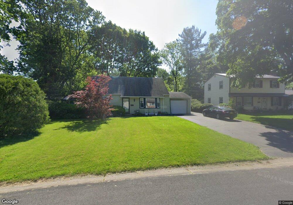
1 Homestead Dr Fairport, NY 14450
Estimated Value: $259,000 - $312,000
3
Beds
2
Baths
1,289
Sq Ft
$227/Sq Ft
Est. Value
About This Home
This home is located at 1 Homestead Dr, Fairport, NY 14450 and is currently estimated at $292,967, approximately $227 per square foot. 1 Homestead Dr is a home located in Monroe County with nearby schools including Northside School, Dudley School, and Johanna Perrin Middle School.
Ownership History
Date
Name
Owned For
Owner Type
Purchase Details
Closed on
May 17, 2010
Sold by
Cass William P
Bought by
Cass William P and Cass Linda J
Current Estimated Value
Home Financials for this Owner
Home Financials are based on the most recent Mortgage that was taken out on this home.
Original Mortgage
$114,500
Interest Rate
4.45%
Mortgage Type
New Conventional
Purchase Details
Closed on
Oct 27, 2005
Sold by
Elliston Edgar
Bought by
Cass William
Home Financials for this Owner
Home Financials are based on the most recent Mortgage that was taken out on this home.
Original Mortgage
$115,963
Interest Rate
5.79%
Mortgage Type
FHA
Purchase Details
Closed on
Nov 8, 1996
Create a Home Valuation Report for This Property
The Home Valuation Report is an in-depth analysis detailing your home's value as well as a comparison with similar homes in the area
Home Values in the Area
Average Home Value in this Area
Purchase History
| Date | Buyer | Sale Price | Title Company |
|---|---|---|---|
| Cass William P | -- | None Available | |
| Cass William | $116,900 | Anthony Jacovangelo | |
| -- | -- | -- |
Source: Public Records
Mortgage History
| Date | Status | Borrower | Loan Amount |
|---|---|---|---|
| Closed | Cass William P | $114,500 | |
| Closed | Cass William | $115,963 |
Source: Public Records
Tax History Compared to Growth
Tax History
| Year | Tax Paid | Tax Assessment Tax Assessment Total Assessment is a certain percentage of the fair market value that is determined by local assessors to be the total taxable value of land and additions on the property. | Land | Improvement |
|---|---|---|---|---|
| 2024 | $6,393 | $142,800 | $33,500 | $109,300 |
| 2023 | $6,065 | $142,800 | $33,500 | $109,300 |
| 2022 | $6,437 | $142,800 | $33,500 | $109,300 |
| 2021 | $6,447 | $142,800 | $33,500 | $109,300 |
| 2020 | $5,670 | $142,800 | $33,500 | $109,300 |
| 2019 | $3,969 | $142,800 | $25,100 | $117,700 |
| 2018 | $5,305 | $142,800 | $25,100 | $117,700 |
| 2017 | $2,402 | $129,800 | $25,100 | $104,700 |
| 2016 | $3,969 | $129,800 | $25,100 | $104,700 |
| 2015 | -- | $129,800 | $25,100 | $104,700 |
| 2014 | -- | $129,800 | $25,100 | $104,700 |
Source: Public Records
Map
Nearby Homes
- 19 Homestead Dr
- 15 Whitney Farms Cir
- 603 Watson Rd
- 70 High St
- 12 Deland Park A
- 1331 Whitney Rd E
- 86 Broxbourne Dr
- 105 Packetts Glen
- 3 Packetts Glen
- 2 Foxpointe Cir
- 112 Roselawn Ave
- 76 - 78 Summit St
- 255 Watson Rd
- 79 Saint Andrews Blvd
- 9 Killeen Dr
- 4 Arbor Ct
- 31 Dewey Ave
- 31 Belinda Crescent
- 34 Belinda Crescent
- 14 Little Briggins Cir
- 3 Homestead Dr
- 1135 Whitney Rd E
- 1151 Whitney Rd E
- 5 Homestead Dr
- 2 Homestead Dr
- 1155 Whitney Rd E
- 1133 Whitney Rd E
- 4 Homestead Dr
- 7 Homestead Dr
- 1161 Whitney Rd E
- 6 Homestead Dr
- 9 Homestead Dr
- 43 Fireside Ln
- 41 Fireside Ln
- 1163 Whitney Rd E Unit 11
- 76 East St
- 1165 Whitney Rd E Unit 1
- 1165 Whitney Rd E
- 72 East St
- 64 East St