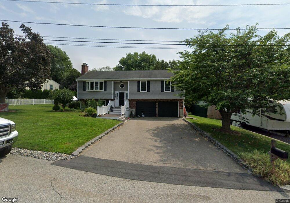
1 Robertson Dr Hopedale, MA 01747
Estimated Value: $507,000 - $565,000
3
Beds
2
Baths
1,362
Sq Ft
$398/Sq Ft
Est. Value
About This Home
This home is located at 1 Robertson Dr, Hopedale, MA 01747 and is currently estimated at $541,629, approximately $397 per square foot. 1 Robertson Dr is a home located in Worcester County with nearby schools including Memorial Elementary School and Hopedale Jr Sr High School.
Ownership History
Date
Name
Owned For
Owner Type
Purchase Details
Closed on
May 15, 2017
Sold by
Orchard Christopher
Bought by
Orchard Christopher and Orchard Gannika
Current Estimated Value
Purchase Details
Closed on
Sep 19, 2012
Sold by
Orchard Christopher and Orchard Erin
Bought by
Orchard Christopher
Purchase Details
Closed on
Nov 20, 2003
Sold by
Perry David A and Perry Louise A
Bought by
Orchard Christopher and Mcmahon Erin
Home Financials for this Owner
Home Financials are based on the most recent Mortgage that was taken out on this home.
Original Mortgage
$302,100
Interest Rate
5.98%
Mortgage Type
Purchase Money Mortgage
Purchase Details
Closed on
Jun 3, 1991
Sold by
Tosches Mildred M
Bought by
Perry David A and Louise A Perry
Purchase Details
Closed on
Oct 15, 1987
Sold by
Dorsey Steven F
Bought by
Tosches M N
Create a Home Valuation Report for This Property
The Home Valuation Report is an in-depth analysis detailing your home's value as well as a comparison with similar homes in the area
Home Values in the Area
Average Home Value in this Area
Purchase History
| Date | Buyer | Sale Price | Title Company |
|---|---|---|---|
| Orchard Christopher | -- | -- | |
| Orchard Christopher | -- | -- | |
| Orchard Christopher | $318,000 | -- | |
| Perry David A | $142,000 | -- | |
| Tosches M N | $167,000 | -- |
Source: Public Records
Mortgage History
| Date | Status | Borrower | Loan Amount |
|---|---|---|---|
| Previous Owner | Orchard Christopher | $302,100 | |
| Previous Owner | Tosches M N | $125,000 | |
| Previous Owner | Tosches M N | $45,000 | |
| Previous Owner | Tosches M N | $25,000 |
Source: Public Records
Tax History Compared to Growth
Tax History
| Year | Tax Paid | Tax Assessment Tax Assessment Total Assessment is a certain percentage of the fair market value that is determined by local assessors to be the total taxable value of land and additions on the property. | Land | Improvement |
|---|---|---|---|---|
| 2025 | $7,380 | $444,300 | $188,600 | $255,700 |
| 2024 | $7,085 | $426,800 | $179,500 | $247,300 |
| 2023 | $6,437 | $398,600 | $176,500 | $222,100 |
| 2022 | $6,291 | $367,700 | $161,800 | $205,900 |
| 2021 | $6,044 | $338,200 | $147,100 | $191,100 |
| 2020 | $5,888 | $338,200 | $147,100 | $191,100 |
| 2019 | $5,605 | $319,000 | $147,100 | $171,900 |
| 2018 | $0 | $307,200 | $140,200 | $167,000 |
| 2017 | $5,139 | $297,200 | $133,600 | $163,600 |
| 2016 | $4,916 | $292,100 | $133,600 | $158,500 |
| 2015 | $4,579 | $276,200 | $124,500 | $151,700 |
Source: Public Records
Map
Nearby Homes
- 0 West St
- 8 Country Club Ln Unit B
- 14 Country Club Ln Unit C
- 76 Jones Rd
- 130 Dutcher St
- 33 Country Club Ln Unit D
- 15 Tammie Rd
- 14 C Country Club Ln
- 9 Hancock St
- 175 West St
- 101 Jones Rd Unit 101
- 104 Jones Rd
- 94 Highland St
- 7 Highland St
- 5 Stanford Cir
- 8 Union St Unit 8
- 7 Madden Ave
- 59 Lawrence St
- 8 Vassar Dr
- 20 Senate Rd
- 3 Robertson Dr
- 197 Dutcher St
- 197 Dutcher St Unit 1
- 201 Dutcher St
- 201 Dutcher St
- 4 Robertson Dr
- 2 Robertson Dr
- 2 Robertson Dr Unit 2
- 2 Robertson Dr Unit 1
- 2A Robertson Dr
- 2A Robertson Dr Unit 2a
- 193 Dutcher St
- 6 Robertson Dr
- 5 Robertson Dr
- 218 West St
- 7 Robertson Dr
- 216 West St
- 216 West St Unit 216 - 1
- 216 West St Unit 216,216
- 205 Dutcher St