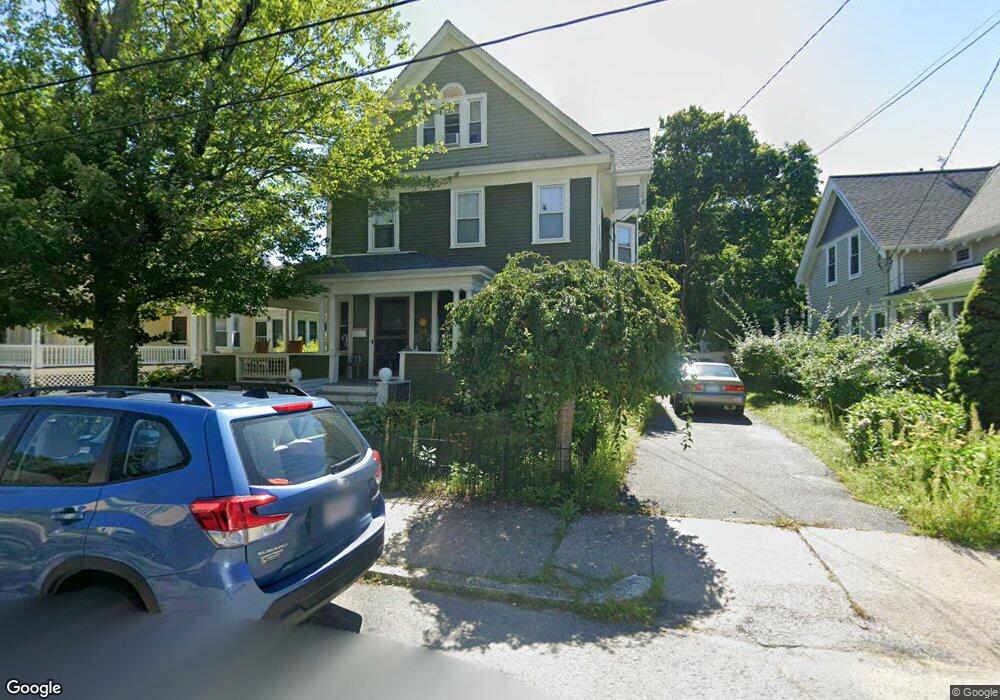
10 Grove St Attleboro, MA 02703
Estimated Value: $514,000 - $567,477
4
Beds
6
Baths
2,756
Sq Ft
$192/Sq Ft
Est. Value
About This Home
This home is located at 10 Grove St, Attleboro, MA 02703 and is currently estimated at $528,869, approximately $191 per square foot. 10 Grove St is a home located in Bristol County with nearby schools including Thomas E. Willett School, Cyril K. Brennan Middle School, and Attleboro High School.
Ownership History
Date
Name
Owned For
Owner Type
Purchase Details
Closed on
Aug 5, 2024
Sold by
Abreau Lisa
Bought by
Abreay Frappier Ret and Abreau
Current Estimated Value
Purchase Details
Closed on
May 28, 2004
Sold by
Prutsman James and Prutsman Lisa
Bought by
Prutsman Lisa
Home Financials for this Owner
Home Financials are based on the most recent Mortgage that was taken out on this home.
Original Mortgage
$165,000
Interest Rate
5.88%
Mortgage Type
Purchase Money Mortgage
Purchase Details
Closed on
Jul 8, 1999
Sold by
Stewart Lynne W and Stewart Kevin L
Bought by
Prutsman James and Prutsman Lisa
Create a Home Valuation Report for This Property
The Home Valuation Report is an in-depth analysis detailing your home's value as well as a comparison with similar homes in the area
Home Values in the Area
Average Home Value in this Area
Purchase History
| Date | Buyer | Sale Price | Title Company |
|---|---|---|---|
| Abreay Frappier Ret | -- | None Available | |
| Abreay Frappier Ret | -- | None Available | |
| Prutsman Lisa | -- | -- | |
| Prutsman Lisa | -- | -- | |
| Prutsman James | $149,900 | -- | |
| Prutsman Lisa | -- | -- | |
| Prutsman James | $149,900 | -- |
Source: Public Records
Mortgage History
| Date | Status | Borrower | Loan Amount |
|---|---|---|---|
| Previous Owner | Prutsman Lisa | $165,000 | |
| Previous Owner | Prutsman James | $150,000 |
Source: Public Records
Tax History Compared to Growth
Tax History
| Year | Tax Paid | Tax Assessment Tax Assessment Total Assessment is a certain percentage of the fair market value that is determined by local assessors to be the total taxable value of land and additions on the property. | Land | Improvement |
|---|---|---|---|---|
| 2025 | $5,182 | $412,900 | $127,200 | $285,700 |
| 2024 | $5,068 | $398,100 | $127,200 | $270,900 |
| 2023 | $4,626 | $337,900 | $115,600 | $222,300 |
| 2022 | $4,440 | $307,300 | $110,100 | $197,200 |
| 2021 | $4,909 | $331,700 | $105,800 | $225,900 |
| 2020 | $4,837 | $332,200 | $102,800 | $229,400 |
| 2019 | $26,827 | $316,000 | $100,800 | $215,200 |
| 2018 | $4,156 | $280,400 | $97,800 | $182,600 |
| 2017 | $4,119 | $283,100 | $97,800 | $185,300 |
| 2016 | $3,606 | $243,300 | $96,000 | $147,300 |
| 2015 | $3,229 | $219,500 | $96,000 | $123,500 |
| 2014 | $3,139 | $211,400 | $91,400 | $120,000 |
Source: Public Records
Map
Nearby Homes