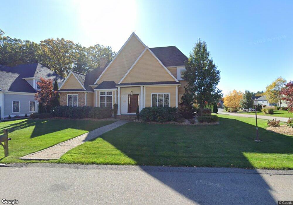
10 Kylie Ln Natick, MA 01760
Estimated Value: $1,979,739 - $2,143,000
4
Beds
5
Baths
4,168
Sq Ft
$493/Sq Ft
Est. Value
About This Home
This home is located at 10 Kylie Ln, Natick, MA 01760 and is currently estimated at $2,054,185, approximately $492 per square foot. 10 Kylie Ln is a home with nearby schools including Natick High School, J F Kennedy Middle School, and Johnson Elementary School.
Ownership History
Date
Name
Owned For
Owner Type
Purchase Details
Closed on
Jan 4, 2024
Sold by
Lousararian Brett J and Lousararian Cara D
Bought by
Lousararian Ft and Lousararian
Current Estimated Value
Purchase Details
Closed on
Jan 4, 2010
Sold by
Edgewater Dev Assoc
Bought by
Brown-Stevenson Tina
Home Financials for this Owner
Home Financials are based on the most recent Mortgage that was taken out on this home.
Original Mortgage
$750,000
Interest Rate
4.85%
Mortgage Type
Purchase Money Mortgage
Create a Home Valuation Report for This Property
The Home Valuation Report is an in-depth analysis detailing your home's value as well as a comparison with similar homes in the area
Home Values in the Area
Average Home Value in this Area
Purchase History
| Date | Buyer | Sale Price | Title Company |
|---|---|---|---|
| Lousararian Ft | -- | None Available | |
| Brown-Stevenson Tina | $1,060,000 | -- |
Source: Public Records
Mortgage History
| Date | Status | Borrower | Loan Amount |
|---|---|---|---|
| Previous Owner | Brown-Stevenson Tina | $750,000 |
Source: Public Records
Tax History Compared to Growth
Tax History
| Year | Tax Paid | Tax Assessment Tax Assessment Total Assessment is a certain percentage of the fair market value that is determined by local assessors to be the total taxable value of land and additions on the property. | Land | Improvement |
|---|---|---|---|---|
| 2025 | $21,923 | $1,833,000 | $493,300 | $1,339,700 |
| 2024 | $21,079 | $1,719,300 | $467,300 | $1,252,000 |
| 2023 | $18,678 | $1,477,700 | $434,500 | $1,043,200 |
| 2022 | $18,026 | $1,351,300 | $391,700 | $959,600 |
| 2021 | $17,477 | $1,284,100 | $386,500 | $897,600 |
| 2020 | $17,266 | $1,268,600 | $371,000 | $897,600 |
| 2019 | $16,124 | $1,268,600 | $371,000 | $897,600 |
| 2018 | $16,357 | $1,253,400 | $358,200 | $895,200 |
| 2017 | $16,609 | $1,231,200 | $352,100 | $879,100 |
| 2016 | $16,589 | $1,222,500 | $352,100 | $870,400 |
| 2015 | $16,299 | $1,179,400 | $352,100 | $827,300 |
Source: Public Records
Map
Nearby Homes
- 4 Sylvia Ave
- 26 Walden Dr Unit 4
- 46 Silver Hill Ln Unit 1
- 9 Silver Hill Ln Unit 19
- 12 Walden Dr Unit 19
- 40 Silver Hill Ln Unit 4
- 32 Silver Hill Ln Unit 1
- 91 Speen St
- 57 Village Brook Ln Unit 5
- 50 Village Brook Ln Unit 4
- 51 Village Brook Ln Unit 16
- 1 Fern St
- 4 Village Rock Ln Unit 9
- 6 Village Rock Ln Unit 17
- 5 Village Rock Ln Unit 24
- 1 Glen St Unit B
- 2 Lodge Rd
- 38 Ranger Rd
- 10 Kelsey Rd
- 150 2nd St Unit 310