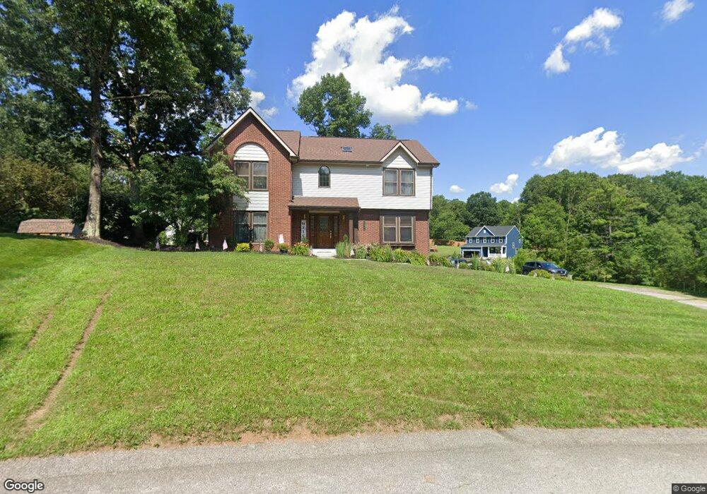
100 Oakwood Cir Gibsonia, PA 15044
West Deer Township NeighborhoodEstimated Value: $446,683 - $489,000
4
Beds
3
Baths
2,192
Sq Ft
$215/Sq Ft
Est. Value
About This Home
This home is located at 100 Oakwood Cir, Gibsonia, PA 15044 and is currently estimated at $470,421, approximately $214 per square foot. 100 Oakwood Cir is a home located in Allegheny County with nearby schools including East Union Intrmd School, Curtisville Pri Center, and Deer Lakes Middle School.
Ownership History
Date
Name
Owned For
Owner Type
Purchase Details
Closed on
Mar 20, 2001
Sold by
Mortgage Guaranty Insurance Corp
Bought by
Grada Leonard M and Grada Doreen R
Current Estimated Value
Purchase Details
Closed on
Aug 2, 2000
Sold by
Federal National Mortgage Association
Bought by
Mortgage Guaranty Insurance Corp
Purchase Details
Closed on
Dec 29, 1999
Sold by
Deasey Brennan R and Deasey Lisa J
Bought by
Federal National Mortgage Association
Purchase Details
Closed on
May 31, 1996
Sold by
Broznick Brian A
Bought by
Deasy Brennan R and Deasy Lisa J
Create a Home Valuation Report for This Property
The Home Valuation Report is an in-depth analysis detailing your home's value as well as a comparison with similar homes in the area
Home Values in the Area
Average Home Value in this Area
Purchase History
| Date | Buyer | Sale Price | Title Company |
|---|---|---|---|
| Grada Leonard M | $180,500 | -- | |
| Mortgage Guaranty Insurance Corp | $192,770 | -- | |
| Federal National Mortgage Association | $1,134 | -- | |
| Deasy Brennan R | $175,000 | -- |
Source: Public Records
Tax History Compared to Growth
Tax History
| Year | Tax Paid | Tax Assessment Tax Assessment Total Assessment is a certain percentage of the fair market value that is determined by local assessors to be the total taxable value of land and additions on the property. | Land | Improvement |
|---|---|---|---|---|
| 2025 | $6,252 | $206,200 | $36,400 | $169,800 |
| 2024 | $6,252 | $206,200 | $36,400 | $169,800 |
| 2023 | $6,271 | $206,200 | $36,400 | $169,800 |
| 2022 | $6,271 | $206,200 | $36,400 | $169,800 |
| 2021 | $975 | $206,200 | $36,400 | $169,800 |
| 2020 | $6,119 | $206,200 | $36,400 | $169,800 |
| 2019 | $6,119 | $206,200 | $36,400 | $169,800 |
| 2018 | $975 | $206,200 | $36,400 | $169,800 |
| 2017 | $6,119 | $206,200 | $36,400 | $169,800 |
| 2016 | $975 | $206,200 | $36,400 | $169,800 |
| 2015 | $975 | $206,200 | $36,400 | $169,800 |
| 2014 | $5,912 | $206,200 | $36,400 | $169,800 |
Source: Public Records
Map
Nearby Homes
- 0 Lot 10 Ashley Rd
- 529 Dana Dr
- 502 Bairdford Rd
- 468 Bairdford Rd
- 1214 Sandstone Ct E
- 1028 Mueller St
- 1022 Mueller St
- 00 Bairdford Rd
- 34 Quigley Rd
- 1772 Saxonburg Blvd
- 0 Snyder St
- 89 Ford St
- 2344 Saxonburg Blvd
- 46 Simon Rd
- 60 Greenleaf Dr
- 33 Peckham Ln
- 1307 Player Way Unit 1307
- 40 Mountain View Rd
- 0 Gibson Rd Unit 1691244
- 27 Skyline Dr
- 113 Ashley Rd
- 112 Ashley Rd
- 134 Ashley Rd
- 102 Oakwood Cir
- 103 Oakwood Cir
- 1003 Ashley Rd
- 144 Oakwood Cir
- 128 Oakwood Cir
- 136 Oakwood Cir
- 104 Oakwood Cir
- 1007 Ashley Rd
- 106 Oakwood Cir
- 127 Oakwood Cir
- 604 Bairdford Rd
- 600 Bairdford Rd
- 126 Oakwood Cir
- 108 Oakwood Cir
- 121 Oakwood Cir
- 1000 Ashley Rd
- 614 Bairdford Rd