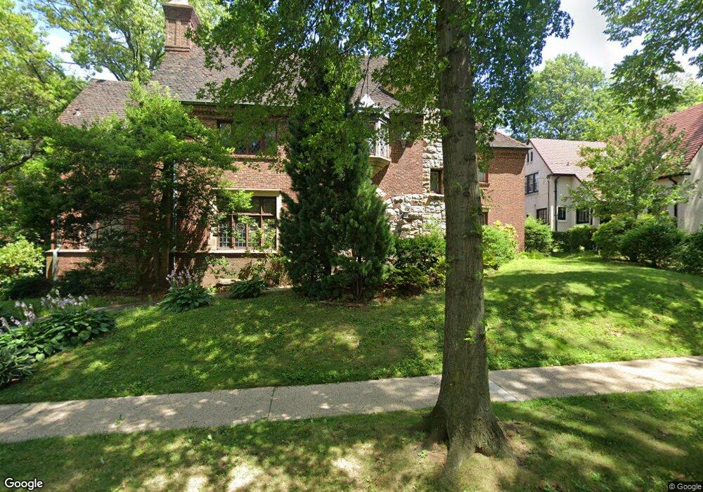
100 Whitson St Forest Hills, NY 11375
Forest Hills NeighborhoodEstimated Value: $990,000 - $4,560,000
--
Bed
--
Bath
6,359
Sq Ft
$448/Sq Ft
Est. Value
About This Home
This home is located at 100 Whitson St, Forest Hills, NY 11375 and is currently estimated at $2,851,203, approximately $448 per square foot. 100 Whitson St is a home located in Queens County with nearby schools including Ps 101 School In The Gardens, J.H.S. 190 Russell Sage, and Queens Metropolitan High School.
Ownership History
Date
Name
Owned For
Owner Type
Purchase Details
Closed on
Jul 15, 1999
Sold by
Mandelbaum Jonathan and Mandelbaum Cynthia
Bought by
Mandelbaum Cynthia P
Current Estimated Value
Purchase Details
Closed on
Sep 27, 1994
Sold by
Mandelbaum Jonathan and Mandelbaum Cynthia
Bought by
Mandelbaum Jonathan and Mandelbaum Cynthia
Create a Home Valuation Report for This Property
The Home Valuation Report is an in-depth analysis detailing your home's value as well as a comparison with similar homes in the area
Home Values in the Area
Average Home Value in this Area
Purchase History
| Date | Buyer | Sale Price | Title Company |
|---|---|---|---|
| Mandelbaum Cynthia P | -- | First American Title Ins Co | |
| Mandelbaum Cynthia P | -- | First American Title Ins Co | |
| Mandelbaum Jonathan | -- | First American Title Ins Co | |
| Mandelbaum Jonathan | -- | First American Title Ins Co |
Source: Public Records
Tax History Compared to Growth
Tax History
| Year | Tax Paid | Tax Assessment Tax Assessment Total Assessment is a certain percentage of the fair market value that is determined by local assessors to be the total taxable value of land and additions on the property. | Land | Improvement |
|---|---|---|---|---|
| 2025 | $39,212 | $208,427 | $23,618 | $184,809 |
| 2024 | $39,224 | $196,630 | $19,431 | $177,199 |
| 2023 | $36,977 | $185,501 | $15,518 | $169,983 |
| 2022 | $36,279 | $300,540 | $30,180 | $270,360 |
| 2021 | $38,252 | $249,120 | $30,180 | $218,940 |
| 2020 | $36,469 | $214,260 | $30,180 | $184,080 |
| 2019 | $33,985 | $235,980 | $30,180 | $205,800 |
| 2018 | $31,214 | $154,584 | $24,747 | $129,837 |
| 2017 | $15,706 | $152,640 | $29,553 | $123,087 |
| 2016 | $30,204 | $152,640 | $29,553 | $123,087 |
| 2015 | $17,148 | $144,741 | $29,443 | $115,298 |
| 2014 | $17,148 | $136,549 | $27,776 | $108,773 |
Source: Public Records
Map
Nearby Homes
- 54 Ingram St
- 23 Whitson St Unit 101
- 72-23 Kessel St
- 7212 Harrow St
- 72-03 Ingram St Unit H0USE
- 16 Upshaw Rd
- 306 Burns St
- 117-01 Park Ln S Unit C5D
- 117-01 Park Ln S Unit B2L
- 117-01 Park Ln S Unit A6E
- 117-01 Park Ln S Unit A6D
- 117-01 Park Ln S Unit C 1F
- 117-01 Park Ln S Unit B3H
- 117-01 Park Ln S Unit A3C
- 117-19 Union Turnpike
- 117-14 Union Turnpike Unit Ac3
- 408 Burns St
- 76-66 Austin St Unit 4B
- 76-66 Austin St Unit 1
- 76-66 Austin St Unit 3
- 116 Whitson St
- 170 Puritan Ave
- 170 75th Rd
- 201 Puritan Ave
- 109 Whitson St
- 199 Puritan Ave
- 199 Puritan Ave
- 75-28 Whitson St
- 205 Puritan Ave
- 197 Puritan Ave
- 193 Puritan Ave
- 191 Puritan Ave
- 111 Whitson St
- 128 Whitson St
- 189 Puritan Ave
- 154 Puritan Ave
- 187 Puritan Ave
- 43 Whitson St Unit 101
- 125 Whitson St
- 38 Whitson St