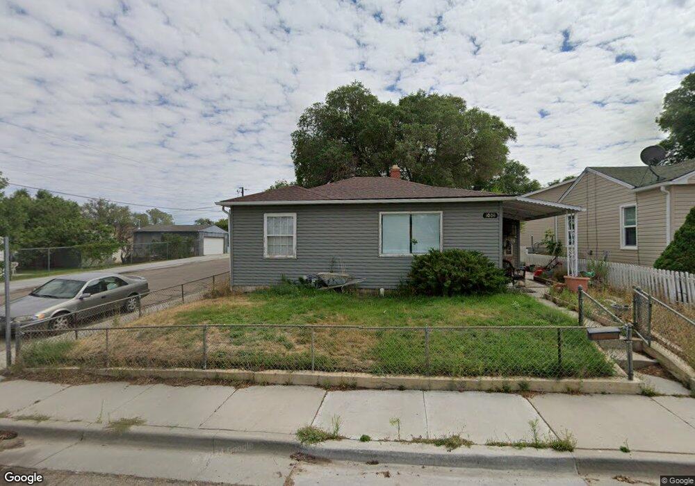
1003 Adams Ave Rock Springs, WY 82901
Estimated Value: $206,000 - $248,417
2
Beds
1
Bath
924
Sq Ft
$243/Sq Ft
Est. Value
About This Home
This home is located at 1003 Adams Ave, Rock Springs, WY 82901 and is currently estimated at $224,472, approximately $242 per square foot. 1003 Adams Ave is a home located in Sweetwater County with nearby schools including Walnut Elementary School, Rock Springs Junior High School, and Rock Springs High School.
Ownership History
Date
Name
Owned For
Owner Type
Purchase Details
Closed on
May 29, 2025
Sold by
Boren Justin Bradley
Bought by
Boren Mya L
Current Estimated Value
Purchase Details
Closed on
Sep 14, 2012
Sold by
Eversole Elza L Trust
Bought by
Boren Justin B
Home Financials for this Owner
Home Financials are based on the most recent Mortgage that was taken out on this home.
Original Mortgage
$141,293
Interest Rate
3.62%
Mortgage Type
FHA
Create a Home Valuation Report for This Property
The Home Valuation Report is an in-depth analysis detailing your home's value as well as a comparison with similar homes in the area
Home Values in the Area
Average Home Value in this Area
Purchase History
| Date | Buyer | Sale Price | Title Company |
|---|---|---|---|
| Boren Mya L | -- | None Listed On Document | |
| Boren Mya L | -- | None Listed On Document | |
| Boren Justin B | $142,705 | -- |
Source: Public Records
Mortgage History
| Date | Status | Borrower | Loan Amount |
|---|---|---|---|
| Previous Owner | Boren Justin B | $141,293 |
Source: Public Records
Tax History Compared to Growth
Tax History
| Year | Tax Paid | Tax Assessment Tax Assessment Total Assessment is a certain percentage of the fair market value that is determined by local assessors to be the total taxable value of land and additions on the property. | Land | Improvement |
|---|---|---|---|---|
| 2025 | $1,214 | $13,226 | $1,781 | $11,445 |
| 2024 | $1,214 | $16,412 | $2,375 | $14,037 |
| 2023 | $1,149 | $15,872 | $2,375 | $13,497 |
| 2022 | $1,052 | $14,394 | $2,375 | $12,019 |
| 2021 | $977 | $13,330 | $2,375 | $10,955 |
| 2020 | $1,017 | $13,901 | $2,375 | $11,526 |
| 2019 | $997 | $13,729 | $2,375 | $11,354 |
| 2018 | $961 | $13,208 | $2,375 | $10,833 |
| 2017 | $954 | $13,044 | $2,375 | $10,669 |
| 2015 | -- | $12,002 | $0 | $0 |
| 2014 | -- | $11,843 | $0 | $0 |
Source: Public Records
Map
Nearby Homes
- 1116 Wyoming St
- 1104 New Hampshire St
- 1002 Wyoming St
- 820 Connecticut Ave
- 804 Connecticut Ave
- 922 New Hampshire St
- 740 Rhode Island Ave
- 716 B St
- 506 R St
- 1805 Carson St
- 805 Walnut St
- 416 R St
- 1210 Mccabe St
- 413 Hay St
- 518 A St
- South Belt Loop N Belt Loop
- 1408 Collins St
- 820 Maple St
- South Belt Loop S Belt Loop
- 220 Liberty St
- 1007 Adams Ave
- 1011 Adams Ave
- 935 Adams Ave
- 1015 Adams Ave
- 931 Adams Ave
- 1019 Adams Ave
- 1004 Adams Ave
- 1008 Adams Ave
- 1012 Adams Ave
- 1012 Adams Ave Unit Thompson
- 936 Adams Ave
- 1023 Adams Ave
- 1016 Adams Ave
- 932 Adams Ave
- 1020 Adams Ave
- 928 Adams Ave
- 928 Adams Ave Unit Wyoming
- 1027 Adams Ave
- 1024 Adams Ave
- 1024 Adams Ave Unit Marchant