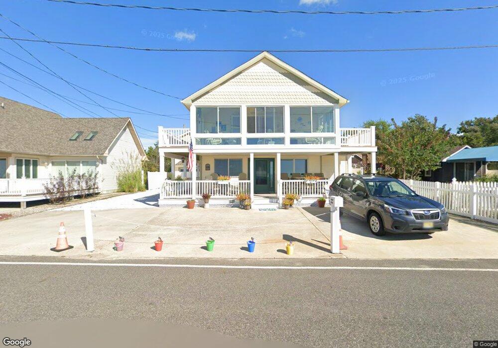
1005 Shore Dr Cape May, NJ 08204
Estimated Value: $1,223,000 - $1,486,000
--
Bed
--
Bath
2,632
Sq Ft
$515/Sq Ft
Est. Value
About This Home
This home is located at 1005 Shore Dr, Cape May, NJ 08204 and is currently estimated at $1,354,645, approximately $514 per square foot. 1005 Shore Dr is a home located in Cape May County with nearby schools including David C. Douglass Veterans Memorial School, Carl T. Mitnick School, and Maud Abrams School.
Ownership History
Date
Name
Owned For
Owner Type
Purchase Details
Closed on
Apr 28, 2006
Sold by
Floria Ronald and Floria Marie
Bought by
Stein Alan P and Bauer Dorothy M
Current Estimated Value
Home Financials for this Owner
Home Financials are based on the most recent Mortgage that was taken out on this home.
Original Mortgage
$385,000
Outstanding Balance
$222,210
Interest Rate
6.34%
Mortgage Type
Fannie Mae Freddie Mac
Estimated Equity
$1,132,435
Purchase Details
Closed on
Jul 26, 2001
Sold by
Costello Dominic J
Bought by
Floria Ronald and Floria Marie
Create a Home Valuation Report for This Property
The Home Valuation Report is an in-depth analysis detailing your home's value as well as a comparison with similar homes in the area
Home Values in the Area
Average Home Value in this Area
Purchase History
| Date | Buyer | Sale Price | Title Company |
|---|---|---|---|
| Stein Alan P | $685,000 | The Title Company Of Jersey | |
| Floria Ronald | $265,000 | -- | |
| Floria Ronald | $265,000 | -- |
Source: Public Records
Mortgage History
| Date | Status | Borrower | Loan Amount |
|---|---|---|---|
| Open | Stein Alan P | $385,000 |
Source: Public Records
Tax History Compared to Growth
Tax History
| Year | Tax Paid | Tax Assessment Tax Assessment Total Assessment is a certain percentage of the fair market value that is determined by local assessors to be the total taxable value of land and additions on the property. | Land | Improvement |
|---|---|---|---|---|
| 2025 | $14,315 | $718,200 | $480,000 | $238,200 |
| 2024 | $14,315 | $718,200 | $480,000 | $238,200 |
| 2023 | $14,107 | $718,200 | $480,000 | $238,200 |
| 2022 | $13,669 | $718,200 | $480,000 | $238,200 |
| 2021 | $13,252 | $718,200 | $480,000 | $238,200 |
| 2020 | $13,037 | $718,200 | $480,000 | $238,200 |
| 2019 | $12,706 | $718,200 | $480,000 | $238,200 |
| 2018 | $12,398 | $718,200 | $480,000 | $238,200 |
| 2017 | $12,412 | $718,200 | $480,000 | $238,200 |
| 2016 | $12,218 | $718,200 | $480,000 | $238,200 |
| 2015 | $11,816 | $718,200 | $480,000 | $238,200 |
| 2014 | $11,421 | $718,200 | $480,000 | $238,200 |
Source: Public Records
Map
Nearby Homes
- 2 Fernwood Rd
- 18 Pinewood Rd
- 101 Avalon Rd
- 514 Baywyn Rd
- 412 Hollywood Rd
- 111A Racetrack Dr
- 106 Racetrack Dr
- 319 Roseann Ave
- 66 Beachhurst Dr
- 3005 Shore Dr
- 219 Town Bank Rd
- 2988 Bybrook Dr
- 236 Roseann Ave
- 1310 Browning Ave
- 1607 Scott Ave
- 86 Beachhurst Dr
- 2710 Bybrook Dr
- 226 Joanne St
- 217 Mindy Ave
- 215 Roseann Ave
- 1007 Shore Dr
- 1003 Shore Dr
- 1000 Glenwood Place
- 1 Pinewood Rd
- 3 Pinewood Rd
- 1011 Shore Dr
- 1001 Glenwood Place
- 907 Shore Dr
- 5 Pinewood Rd
- 2 Pinewood Rd
- 905 Shore Dr
- 4 Pinewood Rd
- 1004 Crest Place
- 903 Shore Dr
- 903 Shore Dr Unit corner Fernwood
- 6 Pinewood Rd
- 3 Fernwood Rd
- 5 Fernwood Rd
- 10 Pinewood Rd
- 7 Fernwood Rd