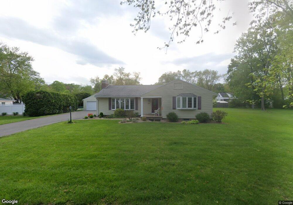
101 Sherwood Ave West Springfield, MA 01089
Estimated Value: $400,992 - $433,000
3
Beds
2
Baths
1,609
Sq Ft
$257/Sq Ft
Est. Value
About This Home
This home is located at 101 Sherwood Ave, West Springfield, MA 01089 and is currently estimated at $413,498, approximately $256 per square foot. 101 Sherwood Ave is a home located in Hampden County with nearby schools including West Springfield High School and St Thomas The Apostle School.
Ownership History
Date
Name
Owned For
Owner Type
Purchase Details
Closed on
Jul 22, 2005
Sold by
Petropoulos Angelo and Petropoulos Stella
Bought by
Nekitopoulos Kathleen A
Current Estimated Value
Home Financials for this Owner
Home Financials are based on the most recent Mortgage that was taken out on this home.
Original Mortgage
$100,000
Outstanding Balance
$51,965
Interest Rate
5.59%
Mortgage Type
Purchase Money Mortgage
Estimated Equity
$361,533
Purchase Details
Closed on
Jun 29, 1998
Sold by
Petropoulos Angelo
Bought by
Barch Christine S
Create a Home Valuation Report for This Property
The Home Valuation Report is an in-depth analysis detailing your home's value as well as a comparison with similar homes in the area
Home Values in the Area
Average Home Value in this Area
Purchase History
| Date | Buyer | Sale Price | Title Company |
|---|---|---|---|
| Nekitopoulos Kathleen A | $270,000 | -- | |
| Barch Christine S | $100,000 | -- |
Source: Public Records
Mortgage History
| Date | Status | Borrower | Loan Amount |
|---|---|---|---|
| Open | Nekitopoulos Kathleen A | $100,000 | |
| Previous Owner | Barch Christine S | $130,000 |
Source: Public Records
Tax History Compared to Growth
Tax History
| Year | Tax Paid | Tax Assessment Tax Assessment Total Assessment is a certain percentage of the fair market value that is determined by local assessors to be the total taxable value of land and additions on the property. | Land | Improvement |
|---|---|---|---|---|
| 2025 | $5,248 | $352,900 | $128,600 | $224,300 |
| 2024 | $5,151 | $347,800 | $128,600 | $219,200 |
| 2023 | $4,931 | $317,300 | $128,600 | $188,700 |
| 2022 | $4,481 | $284,300 | $116,500 | $167,800 |
| 2021 | $4,389 | $259,700 | $109,000 | $150,700 |
| 2020 | $4,400 | $259,000 | $109,000 | $150,000 |
| 2019 | $4,393 | $259,000 | $109,000 | $150,000 |
| 2018 | $4,416 | $259,000 | $109,000 | $150,000 |
| 2017 | $4,416 | $259,000 | $109,000 | $150,000 |
| 2016 | $4,390 | $258,400 | $104,800 | $153,600 |
| 2015 | $4,310 | $253,700 | $102,800 | $150,900 |
| 2014 | $1,047 | $253,700 | $102,800 | $150,900 |
Source: Public Records
Map
Nearby Homes
- 260 Wolcott Ave
- 32 Lotus Ave
- 139 Upper Beverly Hills
- 7 Brewster Rd
- 148 Craiwell Ave
- 16 North St
- 169 Chilson Rd
- 123 Belknap Ave
- 258 Poplar Ave
- 54 Churchill Rd
- 65 Verdugo St
- 42 Janet St
- 236 Forest Glen
- 43 Greenleaf Ave
- 43 Wishing Well Way
- 73 Maple Terrace
- 36 Maple Terrace
- 74 Maple Terrace
- 22 Beech Hill Rd
- 30 Chestnut St
- 87 Sherwood Ave
- 112 Wolcott Ave
- 92 Wolcott Ave
- 100 Sherwood Ave
- 86 Wolcott Ave
- 77 Sherwood Ave
- 120 Wolcott Ave
- 86 Sherwood Ave
- 80 Wolcott Ave
- 95 Northwood Ave
- 99 Wolcott Ave
- 105 Wolcott Ave
- 69 Sherwood Ave
- 83 Northwood Ave
- 91 Wolcott Ave
- 115 Wolcott Ave
- 74 Sherwood Ave
- 132 Wolcott Ave
- 70 Wolcott Ave
- 81 Wolcott Ave