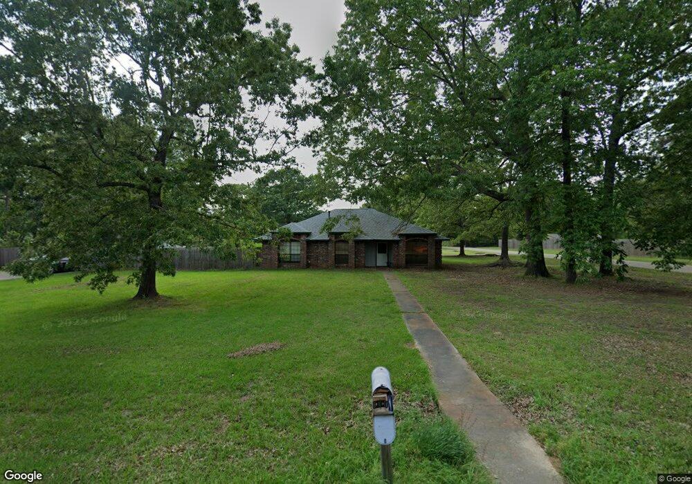
102 Coke Dr Texarkana, TX 75501
Estimated Value: $197,945 - $282,000
--
Bed
--
Bath
1,544
Sq Ft
$154/Sq Ft
Est. Value
About This Home
This home is located at 102 Coke Dr, Texarkana, TX 75501 and is currently estimated at $237,736, approximately $153 per square foot. 102 Coke Dr is a home located in Bowie County with nearby schools including Liberty-Eylau Early Childhood Center, Liberty-Eylau Primary School, and Liberty-Eylau C.K. Bender Elementary Campus.
Ownership History
Date
Name
Owned For
Owner Type
Purchase Details
Closed on
Nov 11, 2013
Sold by
Pickens William R and Pickens Emma Lou
Bought by
Wisenbaker Melinda A
Current Estimated Value
Home Financials for this Owner
Home Financials are based on the most recent Mortgage that was taken out on this home.
Original Mortgage
$123,469
Outstanding Balance
$91,979
Interest Rate
4.28%
Mortgage Type
New Conventional
Estimated Equity
$145,757
Purchase Details
Closed on
Jul 31, 2013
Sold by
Teague Myron L and Teague Kristen
Bought by
Pickens William R
Create a Home Valuation Report for This Property
The Home Valuation Report is an in-depth analysis detailing your home's value as well as a comparison with similar homes in the area
Home Values in the Area
Average Home Value in this Area
Purchase History
| Date | Buyer | Sale Price | Title Company |
|---|---|---|---|
| Wisenbaker Melinda A | -- | Twin City Title | |
| Pickens William R | -- | None Available |
Source: Public Records
Mortgage History
| Date | Status | Borrower | Loan Amount |
|---|---|---|---|
| Open | Wisenbaker Melinda A | $123,469 |
Source: Public Records
Tax History Compared to Growth
Tax History
| Year | Tax Paid | Tax Assessment Tax Assessment Total Assessment is a certain percentage of the fair market value that is determined by local assessors to be the total taxable value of land and additions on the property. | Land | Improvement |
|---|---|---|---|---|
| 2025 | $1,992 | $212,006 | $16,500 | $195,506 |
| 2024 | $1,992 | $210,661 | $16,500 | $199,498 |
| 2023 | $2,861 | $191,510 | $0 | $0 |
| 2022 | $3,000 | $191,536 | $16,500 | $175,036 |
| 2021 | $2,900 | $158,273 | $15,000 | $143,273 |
| 2020 | $2,799 | $151,653 | $15,000 | $136,653 |
| 2019 | $2,823 | $145,343 | $15,000 | $130,343 |
| 2018 | $2,729 | $140,479 | $15,000 | $125,479 |
| 2017 | $2,657 | $137,305 | $15,000 | $122,305 |
| 2016 | $2,657 | $137,305 | $15,000 | $122,305 |
| 2015 | $2,315 | $136,144 | $15,000 | $121,144 |
| 2014 | $2,315 | $123,827 | $15,000 | $108,827 |
Source: Public Records
Map
Nearby Homes
- 403 Brookfield St
- 2043 Randall Rd
- 6514 Buchanan Loop Rd
- 0 Randall Rd
- 101 Redwood Dr
- 194 W Starlite Dr
- 6815 Buchanan Loop Rd
- lot15 B2 Quail Brook
- lot15 B1 Quail Brook
- lot14 B2 Quail Brook
- Lot 1 B2 Quail Brook
- 6 Southridge St
- 280 Patriot Way
- 39 Quail Brook Dr
- 144 Joe Tyl Rd
- 6606 Us-59
- 6606 Us Highway 59 S
- 5789 U S 59
- 7689 Us-59
- 7685 State Highway 59