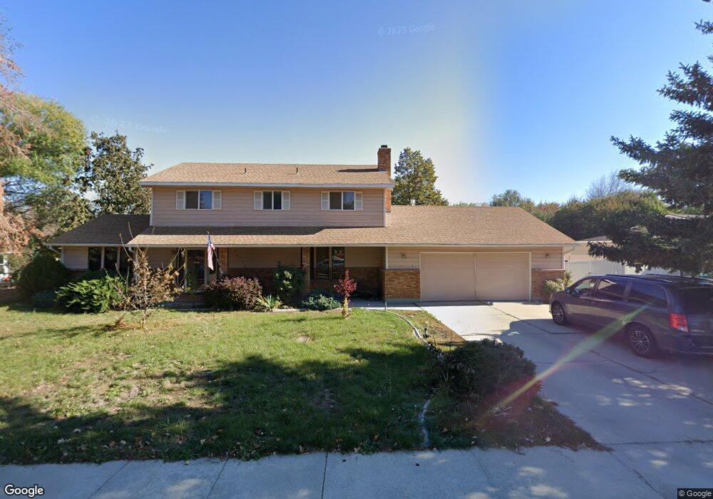
10358 Harvester Dr Boise, ID 83709
Southwest Boise NeighborhoodEstimated Value: $538,000 - $562,000
4
Beds
4
Baths
1,968
Sq Ft
$280/Sq Ft
Est. Value
About This Home
This home is located at 10358 Harvester Dr, Boise, ID 83709 and is currently estimated at $550,581, approximately $279 per square foot. 10358 Harvester Dr is a home located in Ada County with nearby schools including Maple Grove Elementary School, West Junior High School, and Borah Senior High School.
Ownership History
Date
Name
Owned For
Owner Type
Purchase Details
Closed on
Oct 30, 2019
Sold by
Owen Mitchell Dean
Bought by
Smith Eric and Smith Jacqucline
Current Estimated Value
Home Financials for this Owner
Home Financials are based on the most recent Mortgage that was taken out on this home.
Original Mortgage
$268,400
Outstanding Balance
$236,591
Interest Rate
3.7%
Mortgage Type
New Conventional
Estimated Equity
$313,990
Purchase Details
Closed on
Oct 17, 2019
Sold by
Jones Robert F
Bought by
Owen Mitchell Dean and Estate Of Helena Henrika Jones
Home Financials for this Owner
Home Financials are based on the most recent Mortgage that was taken out on this home.
Original Mortgage
$268,400
Outstanding Balance
$236,591
Interest Rate
3.7%
Mortgage Type
New Conventional
Estimated Equity
$313,990
Create a Home Valuation Report for This Property
The Home Valuation Report is an in-depth analysis detailing your home's value as well as a comparison with similar homes in the area
Home Values in the Area
Average Home Value in this Area
Purchase History
| Date | Buyer | Sale Price | Title Company |
|---|---|---|---|
| Smith Eric | -- | Pioneer Title Co Of Ada Cnty | |
| Owen Mitchell Dean | -- | Pioneer Title Co Of Ada Cnty |
Source: Public Records
Mortgage History
| Date | Status | Borrower | Loan Amount |
|---|---|---|---|
| Open | Smith Eric | $268,400 |
Source: Public Records
Tax History Compared to Growth
Tax History
| Year | Tax Paid | Tax Assessment Tax Assessment Total Assessment is a certain percentage of the fair market value that is determined by local assessors to be the total taxable value of land and additions on the property. | Land | Improvement |
|---|---|---|---|---|
| 2025 | $4,227 | $491,500 | -- | -- |
| 2024 | $4,151 | $465,800 | -- | -- |
| 2023 | $4,151 | $434,700 | $0 | $0 |
| 2022 | $4,336 | $500,100 | $0 | $0 |
| 2021 | $4,637 | $424,300 | $0 | $0 |
| 2020 | $3,965 | $334,000 | $0 | $0 |
| 2019 | $3,099 | $328,400 | $0 | $0 |
| 2018 | $2,769 | $282,400 | $0 | $0 |
| 2017 | $3,123 | $260,600 | $0 | $0 |
| 2016 | $2,318 | $236,300 | $0 | $0 |
| 2015 | $947 | $223,200 | $0 | $0 |
| 2012 | -- | $153,400 | $0 | $0 |
Source: Public Records
Map
Nearby Homes
- 2033 S Stonyfield Place
- 10471 W Bantam St
- 10334 W Bantam St
- 10685 W Hollandale Dr
- 1877 S Rustic Mill Place
- 9999 W Hollandale Dr
- 2484 S Culpeper Ave
- 10875 W Hollandale Dr
- 10776 W Smoke Ranch Dr
- 2029 S Wilde Creek Way
- 9631 W Ottawa Ct
- 10210 W Hackamore Dr
- 10512 W Martingale Dr
- 971 S Wavetrain Ave
- 10324 W Antietam St
- 960 S Nautilus Ave
- 941 S Wavetrain Ave
- 937 S Nautilus Ave
- 9916 W Geronimo St
- 11505 W Baserri Dr
- 10358 Harvester Ct
- 10332 Harvester Dr
- 10384 Harvester Dr
- 10306 Harvester Dr
- 10245 Countryman Dr
- 10263 Countryman Dr
- 10357 Harvester Dr
- 10464 W Harvester Ct
- 10464 Harvester Ct
- 10341 W Southerland Dr
- 10227 Countryman Dr
- 10280 Harvester Dr
- 10280 W Harvester Dr
- 10423 W Southerland Dr
- 10209 Countryman Dr
- 10305 Harvester Dr
- 10443 Harvester Ct
- 10297 Countryman Dr
- 10254 Harvester Dr
- 10398 W Southerland Dr