


1045 Upper Gragston Creek Rd Prichard, WV 25555
Estimated payment $1,889/month
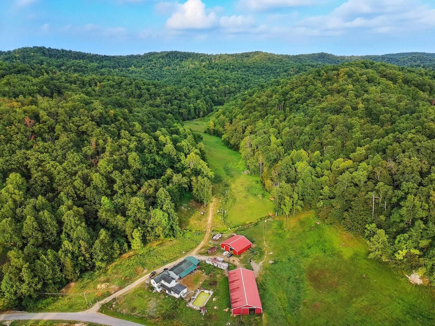
Highlights
- Hot Property
- Stables
- Farm
- Barn
- 215.89 Acre Lot
- Creek On Lot
About This Lot
Discover the boundless potential of this exceptional 215-acre farm nestled in the serene hills of Prichard, WV. Whether you're seeking a private retreat or a working farm this remarkable property offers the space, structure, and natural beauty to bring your vision to life. The land features a harmonious mix of rolling pastures, mature woodlands, and open fields-ideal for grazing, farming, or outdoor recreation. A classic barn stands proudly on the property, offering ample storage for equipment, feed, or hay. Nearby, a well-maintained stable provides a ready-made setup for horses or livestock, with the capacity and layout to accommodate a variety of agricultural pursuits. The property combines privacy with convenience. Whether you're cultivating crops, expanding your herd, or simply soaking in the mountain scenery, this land offers a rare opportunity to own a piece of Appalachian tranquility. Let your rural dreams take root- this is more than just land; it's a lifestyle waiting to be lived!
Property Details
Property Type
- Land
Est. Annual Taxes
- $290
Lot Details
- 215.89 Acre Lot
- Barbed Wire
- Level Lot
Farming
- Barn
- Farm
Utilities
- Septic System
- Private Sewer
Additional Features
- Creek On Lot
- Mineral Rights
- Stables
Listing and Financial Details
- Assessor Parcel Number 0056
Map
Home Values in the Area
Average Home Value in this Area
Tax History
| Year | Tax Paid | Tax Assessment Tax Assessment Total Assessment is a certain percentage of the fair market value that is determined by local assessors to be the total taxable value of land and additions on the property. | Land | Improvement |
|---|---|---|---|---|
| 2024 | $290 | $43,680 | $9,480 | $34,200 |
| 2023 | $283 | $43,020 | $9,480 | $33,540 |
| 2022 | $299 | $44,220 | $9,480 | $34,740 |
| 2021 | $293 | $43,740 | $9,480 | $34,260 |
| 2020 | $285 | $43,020 | $9,480 | $33,540 |
| 2019 | $277 | $42,300 | $9,480 | $32,820 |
| 2018 | $273 | $41,940 | $9,480 | $32,460 |
| 2017 | $289 | $43,260 | $9,480 | $33,780 |
| 2016 | $278 | $42,480 | $9,420 | $33,060 |
| 2015 | $204 | $36,440 | $9,420 | $27,020 |
| 2014 | $195 | $35,540 | $9,420 | $26,120 |
Property History
| Date | Event | Price | Change | Sq Ft Price |
|---|---|---|---|---|
| 09/02/2025 09/02/25 | For Sale | $350,000 | -- | -- |
Source: Huntington Board of REALTORS®
MLS Number: 182104
APN: 01-4-00560000
Disclaimer: Certain information contained herein is derived from information provided by parties other than Homes.com. All information provided is deemed reliable, but is not guaranteed to be accurate and should be independently verified.
![]() IDX information is provided exclusively for personal, non-commercial use, and may not be used for any purpose other than to identify prospective properties consumers may be interested in purchasing.
IDX information is provided exclusively for personal, non-commercial use, and may not be used for any purpose other than to identify prospective properties consumers may be interested in purchasing.
Information is deemed reliable but not guaranteed.
- 1254 Upper Gragston Creek
- 270 Stanley Dr
- 65 Stanley Dr
- 8245 Whites Creek Rd
- 3419 Garretts Creek Rd
- 1489 Toms Creek Rd
- 7915 Linda Cir
- 76 Smith St
- 1797 Big Creek Rd
- 142 Pyles Branch Rd
- 15280 W Virginia 152
- 15539 Route 152
- 2175 Fort Gay Rd
- 120 Maggie Ln
- 167 Wallace Dr
- 309 Sansom Ave
- 60 Garrett Dr
- 00 W Virginia 152
- 157 Woodland Ct
- 330 Kenova Ave
- 8555 Orchard St
- 3333 8th St
- 2930-2950 Auburn Rd
- 1916 Beech St Unit A2
- 2305-2309 Adams Ave Unit 27
- 2305 Adams Ave Unit 25
- 525 10th St W Unit 525 10TH STREET WEST
- 1212 7th St
- 1127 9th St
- 403 8th Ave Unit 1
- 1024-1028 8th St Unit 2
- 909 11th Ave
- 511 2nd St Unit 3
- 511 2nd St Unit 1
- 511 2nd St Unit 4
- 903-911 9th Ave
- 914 10th St
- 1340 4th Ave Unit 10
- 919 13th St Unit 2
- 1510 7th Ave
