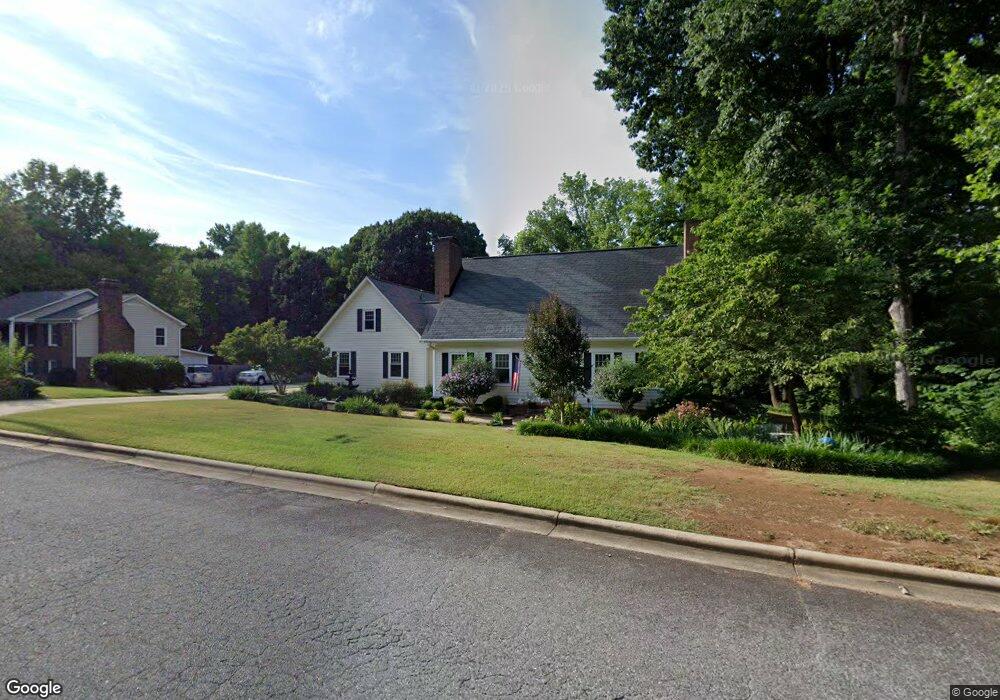
1050 Obarr Dr Gastonia, NC 28054
Estimated Value: $470,000 - $522,000
3
Beds
2
Baths
2,877
Sq Ft
$172/Sq Ft
Est. Value
About This Home
This home is located at 1050 Obarr Dr, Gastonia, NC 28054 and is currently estimated at $494,653, approximately $171 per square foot. 1050 Obarr Dr is a home located in Gaston County with nearby schools including Robinson Elementary School, W P Grier Middle School, and Ashbrook High School.
Ownership History
Date
Name
Owned For
Owner Type
Purchase Details
Closed on
Jul 13, 2006
Sold by
Sullivan Bernard H and Sullivan Beverly G
Bought by
Hollingshead Jason Costner and Pringle Gregory J
Current Estimated Value
Home Financials for this Owner
Home Financials are based on the most recent Mortgage that was taken out on this home.
Original Mortgage
$147,900
Interest Rate
6.6%
Mortgage Type
Purchase Money Mortgage
Create a Home Valuation Report for This Property
The Home Valuation Report is an in-depth analysis detailing your home's value as well as a comparison with similar homes in the area
Home Values in the Area
Average Home Value in this Area
Purchase History
| Date | Buyer | Sale Price | Title Company |
|---|---|---|---|
| Hollingshead Jason Costner | $174,000 | None Available |
Source: Public Records
Mortgage History
| Date | Status | Borrower | Loan Amount |
|---|---|---|---|
| Closed | Hollingshead Jason Costner | $147,900 |
Source: Public Records
Tax History Compared to Growth
Tax History
| Year | Tax Paid | Tax Assessment Tax Assessment Total Assessment is a certain percentage of the fair market value that is determined by local assessors to be the total taxable value of land and additions on the property. | Land | Improvement |
|---|---|---|---|---|
| 2025 | $4,493 | $420,260 | $32,500 | $387,760 |
| 2024 | $4,493 | $420,260 | $32,500 | $387,760 |
| 2023 | $4,539 | $420,260 | $32,500 | $387,760 |
| 2022 | $3,489 | $262,300 | $28,000 | $234,300 |
| 2021 | $3,541 | $262,300 | $28,000 | $234,300 |
| 2019 | $3,567 | $262,300 | $28,000 | $234,300 |
| 2018 | $3,074 | $219,567 | $28,800 | $190,767 |
| 2017 | $3,074 | $219,567 | $28,800 | $190,767 |
| 2016 | $3,074 | $219,567 | $0 | $0 |
| 2014 | $3,403 | $243,049 | $36,000 | $207,049 |
Source: Public Records
Map
Nearby Homes
- 2020 Dawnshire Dr
- 1026 Holly Dr
- 922 Holly Dr
- 1678 Union Rd
- 1643 Laurel Ln
- 1287 Queensgate St
- 1402 Somersby Cir
- 1280 Queensgate St
- 1634 Union Rd
- 1922 Elmwood Dr
- Asheboro Plan at Robinson Oaks
- Colfax Plan at Robinson Oaks
- Charleston Plan at Robinson Oaks
- Cypress Plan at Robinson Oaks
- Davidson Plan at Robinson Oaks
- McDowell Plan at Robinson Oaks
- Roanoke Plan at Robinson Oaks
- 1638 Union Rd Unit A
- 1115 Dumbarton Rd
- 1735 Robinwood Rd Unit 1735
- 1040 Obarr Dr
- 2019 Dawnshire Dr
- 1051 Obarr Dr
- 1030 Obarr Dr
- 1037 Obarr Dr
- 2010 Dawnshire Dr
- 1025 Obarr Dr
- 2030 Donegal Ct
- 2030 Dawnshire Dr
- 2020 Donegal Ct
- 1040 Robin Ln
- 1026 Robin Ln
- 1013 Obarr Dr
- 2070 Dawnshire Dr
- 2013 Shannon Dr
- 1010 Robin Ln
- 1010 Robin Ln Unit 12
- 2185 Windley Dr Unit Lot 32
- 2236 Cutter Dr Unit Lot 28
- 2228 Cutter Dr Unit Lot 29