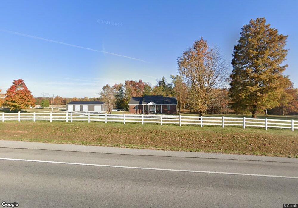
1051 E State Road 256 Austin, IN 47102
Estimated Value: $239,000 - $601,131
3
Beds
3
Baths
2,016
Sq Ft
$229/Sq Ft
Est. Value
About This Home
This home is located at 1051 E State Road 256, Austin, IN 47102 and is currently estimated at $462,044, approximately $229 per square foot. 1051 E State Road 256 is a home located in Scott County with nearby schools including Austin Elementary School, Austin Middle School, and Austin High School.
Ownership History
Date
Name
Owned For
Owner Type
Purchase Details
Closed on
Jul 18, 2023
Sold by
White Tyler
Bought by
Cliver Robert
Current Estimated Value
Purchase Details
Closed on
Jun 10, 2019
Sold by
Melton Wanda J
Bought by
White Tyler
Purchase Details
Closed on
Mar 3, 2015
Sold by
Melton Wanda J
Bought by
Department Of Transportation
Purchase Details
Closed on
May 14, 2007
Sold by
Hampton Bobby J and Hampton Marilyn S
Bought by
Melton Vernon and Melton Wanda J
Purchase Details
Closed on
May 5, 2007
Sold by
Hampton Bobby J and Hampton Marilyn S
Bought by
Melton Vernon and Melton Wanda J
Purchase Details
Closed on
Nov 2, 2005
Sold by
Hampton Marilyn S
Bought by
Hampton Boby J and Hampton Marilyn S
Home Financials for this Owner
Home Financials are based on the most recent Mortgage that was taken out on this home.
Original Mortgage
$60,000
Interest Rate
9.6%
Mortgage Type
Adjustable Rate Mortgage/ARM
Create a Home Valuation Report for This Property
The Home Valuation Report is an in-depth analysis detailing your home's value as well as a comparison with similar homes in the area
Home Values in the Area
Average Home Value in this Area
Purchase History
| Date | Buyer | Sale Price | Title Company |
|---|---|---|---|
| Cliver Robert | $550,000 | Aristocrat Title Llc | |
| White Tyler | -- | None Available | |
| Department Of Transportation | $41,080 | None Available | |
| Melton Vernon | $155,000 | -- | |
| Melton Vernon | -- | None Available | |
| Hampton Boby J | -- | None Available |
Source: Public Records
Mortgage History
| Date | Status | Borrower | Loan Amount |
|---|---|---|---|
| Previous Owner | Hampton Boby J | $60,000 |
Source: Public Records
Tax History Compared to Growth
Tax History
| Year | Tax Paid | Tax Assessment Tax Assessment Total Assessment is a certain percentage of the fair market value that is determined by local assessors to be the total taxable value of land and additions on the property. | Land | Improvement |
|---|---|---|---|---|
| 2024 | $5,869 | $393,800 | $61,200 | $332,600 |
| 2023 | $4,636 | $306,900 | $51,700 | $255,200 |
| 2022 | $4,352 | $318,900 | $51,700 | $267,200 |
| 2021 | $3,784 | $283,900 | $43,800 | $240,100 |
| 2020 | $3,083 | $215,000 | $43,800 | $171,200 |
| 2019 | $1,745 | $152,300 | $43,800 | $108,500 |
| 2018 | $1,637 | $143,300 | $41,700 | $101,600 |
| 2017 | $1,664 | $148,100 | $46,000 | $102,100 |
| 2016 | $1,915 | $162,300 | $48,000 | $114,300 |
| 2014 | $3,159 | $156,500 | $52,000 | $104,500 |
| 2013 | $3,159 | $168,700 | $20,000 | $148,700 |
Source: Public Records
Map
Nearby Homes
- 1062 E State Road 256
- 329 E Cutshall Rd
- 1671 Burns Ct
- 3095 N Coffee Pot Rd
- 2653 N Coffee Pot Rd
- 765 E Marshfield Rd
- 92 Stonybrook Dr
- 3119 E State Road 256
- 5449 N Terry Rd
- 3183 New Frankfort Rd
- 746 Goodin Dr
- 748 Goodin Dr
- 232 E Main St
- 5038 S US Highway 31
- 220 Mann Ave
- 4198 S Us Highway 31
- 569 Broadway St
- 139 Factory Dr
- 255 N Church St
- 1153 Clay St
- 3552 N Bogardus Rd
- 1051 Indiana 256
- 1018 W Kent Street 256
- 1018 E State Road 256
- 1114 E State Road 256
- 3428 N Slab Rd
- 1178 E State Road 256
- 3396 N Slab Rd
- 3670 N Bogardus Rd
- 3354 N Slab Rd
- 0 Cameron Dr
- 1113 Cameron Dr
- 1151 Cameron Dr
- 3296 N Slab Rd
- 807 E State Road 256
- 3276 N Slab Rd
- 3249 N Slab Rd
- 1100 Brandon Ln
- 1142 Brandon Ln