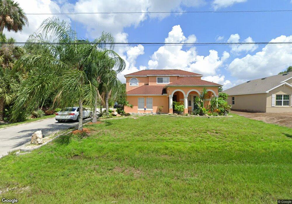
1070 Jinright Rd North Port, FL 34288
Estimated Value: $348,526 - $481,000
3
Beds
3
Baths
2,258
Sq Ft
$174/Sq Ft
Est. Value
About This Home
This home is located at 1070 Jinright Rd, North Port, FL 34288 and is currently estimated at $392,382, approximately $173 per square foot. 1070 Jinright Rd is a home located in Sarasota County with nearby schools including Atwater Elementary School, North Port High School, and Woodland Middle School.
Ownership History
Date
Name
Owned For
Owner Type
Purchase Details
Closed on
Nov 21, 2003
Sold by
Ivannik Roman and Ptitsyn Olga
Bought by
Ptitsyn Olga
Current Estimated Value
Home Financials for this Owner
Home Financials are based on the most recent Mortgage that was taken out on this home.
Original Mortgage
$164,040
Outstanding Balance
$75,944
Interest Rate
5.98%
Estimated Equity
$316,438
Purchase Details
Closed on
Apr 14, 2003
Sold by
Sobon Irving J and Sobon Lois M
Bought by
Campion Lanphier and Campion Donna
Create a Home Valuation Report for This Property
The Home Valuation Report is an in-depth analysis detailing your home's value as well as a comparison with similar homes in the area
Home Values in the Area
Average Home Value in this Area
Purchase History
| Date | Buyer | Sale Price | Title Company |
|---|---|---|---|
| Ptitsyn Olga | -- | -- | |
| Campion Lanphier | $3,600 | -- |
Source: Public Records
Mortgage History
| Date | Status | Borrower | Loan Amount |
|---|---|---|---|
| Open | Ptitsyn Olga | $164,040 |
Source: Public Records
Tax History Compared to Growth
Tax History
| Year | Tax Paid | Tax Assessment Tax Assessment Total Assessment is a certain percentage of the fair market value that is determined by local assessors to be the total taxable value of land and additions on the property. | Land | Improvement |
|---|---|---|---|---|
| 2024 | $2,093 | $142,539 | -- | -- |
| 2023 | $2,093 | $124,787 | $0 | $0 |
| 2022 | $2,256 | $134,752 | $0 | $0 |
| 2021 | $2,219 | $130,827 | $0 | $0 |
| 2020 | $2,187 | $129,021 | $0 | $0 |
| 2019 | $2,108 | $126,120 | $0 | $0 |
| 2018 | $1,954 | $123,768 | $0 | $0 |
| 2017 | $1,904 | $121,222 | $0 | $0 |
| 2016 | $1,904 | $174,100 | $6,400 | $167,700 |
| 2015 | $1,923 | $148,500 | $5,100 | $143,400 |
| 2014 | $1,823 | $111,036 | $0 | $0 |
Source: Public Records
Map
Nearby Homes
- 1901 E Price Blvd
- 1309 Nackman Rd
- 0 W Taggard Rd Unit 317421
- 1072 Henning St
- 0 Jinright Rd Unit C7457580
- 0 Jinright Rd Unit MFRO6294526
- 0 Jinright Rd Unit MFRA4631810
- 0 Jinright Rd Unit MFRO6294525
- TBD Nackman Rd
- 0 E Price Blvd Unit MFRA4663381
- 0 E Price Blvd Unit D6125861
- 0 E Price Blvd Unit D6125860
- 0 E Price Blvd Unit MFRA4615768
- 0 E Price Blvd Unit D6125858
- 0 E Price Blvd Unit LOT 9 MFRS5122578
- 0 E Price Blvd Unit MFRTB8324590
- 0 E Price Blvd Unit MFRA4663384
- TBD Ike St
- 0 E Price Blvd Unit MFRA4568243
- 0 E Price Blvd Unit D6125859
- 1096 Jinright Rd
- 1059 Jinright Rd
- 0 Henning St Unit A4196098
- 0 Henning St Unit MFRO6309533
- 0 Henning St Unit MFRTB8363596
- 0 Henning St Unit MFRC7482266
- 0 Henning St Unit MFRT3451232
- 0 Henning St Unit A4563946
- 0 Henning St Unit A4563932
- 0 Henning St Unit D6129112
- 0 Henning St Unit C7469768
- 0 Henning St Unit C7468746
- 0 Henning St Unit C7463396
- 0 Henning St Unit A4524019
- 0 Henning St Unit A4521599
- 0 Henning St Unit N6118761
- 0 Henning St Unit N6117763
- 0 Henning St Unit C7447251
- 0 Henning St Unit L4923279
- 0 Henning St Unit C7438580