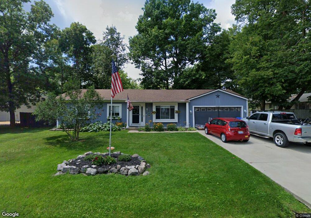
1080 Shady Ln Waterford, MI 48327
Waterford Township NeighborhoodEstimated Value: $289,000 - $331,000
3
Beds
2
Baths
1,260
Sq Ft
$239/Sq Ft
Est. Value
About This Home
This home is located at 1080 Shady Ln, Waterford, MI 48327 and is currently estimated at $300,799, approximately $238 per square foot. 1080 Shady Ln is a home located in Oakland County with nearby schools including Haviland Elementary School, Pierce Middle School, and Waterford Mott High School.
Ownership History
Date
Name
Owned For
Owner Type
Purchase Details
Closed on
Jan 2, 2019
Sold by
Lynn Gary N and Lynn Sandra D
Bought by
Lynn Gary N and Lynn Sandra D
Current Estimated Value
Purchase Details
Closed on
Dec 18, 1996
Sold by
Mccullough Joanne F
Bought by
Lynn Gary N
Home Financials for this Owner
Home Financials are based on the most recent Mortgage that was taken out on this home.
Original Mortgage
$103,000
Outstanding Balance
$10,375
Interest Rate
7.6%
Mortgage Type
Purchase Money Mortgage
Estimated Equity
$290,424
Create a Home Valuation Report for This Property
The Home Valuation Report is an in-depth analysis detailing your home's value as well as a comparison with similar homes in the area
Home Values in the Area
Average Home Value in this Area
Purchase History
| Date | Buyer | Sale Price | Title Company |
|---|---|---|---|
| Lynn Gary N | -- | None Available | |
| Lynn Gary N | $133,500 | -- |
Source: Public Records
Mortgage History
| Date | Status | Borrower | Loan Amount |
|---|---|---|---|
| Open | Lynn Gary N | $103,000 |
Source: Public Records
Tax History Compared to Growth
Tax History
| Year | Tax Paid | Tax Assessment Tax Assessment Total Assessment is a certain percentage of the fair market value that is determined by local assessors to be the total taxable value of land and additions on the property. | Land | Improvement |
|---|---|---|---|---|
| 2024 | $1,697 | $125,470 | $0 | $0 |
| 2023 | $1,618 | $120,360 | $0 | $0 |
| 2022 | $2,605 | $113,360 | $0 | $0 |
| 2021 | $2,503 | $110,080 | $0 | $0 |
| 2020 | $1,482 | $109,220 | $0 | $0 |
| 2019 | $2,941 | $96,610 | $0 | $0 |
| 2018 | $2,388 | $90,090 | $0 | $0 |
| 2017 | $2,196 | $90,090 | $0 | $0 |
| 2016 | $2,192 | $78,540 | $0 | $0 |
| 2015 | -- | $71,890 | $0 | $0 |
| 2014 | -- | $66,940 | $0 | $0 |
| 2011 | -- | $61,480 | $0 | $0 |
Source: Public Records
Map
Nearby Homes
- 1036 Pelham Blvd
- 1020 Charest Ave
- 4616 Cass Elizabeth Rd
- 4910 Chipman Dr
- 1522 Oregon Ct
- 4390 Cass Elizabeth Rd
- 1029 Monica Place
- 00000 Muskingum
- 1062 Forest Bay Dr
- 1079 Forest Bay Dr
- 1677 Parkview Ave
- 4275 Forest Valley Ct
- 5171 Durnham Dr
- 941 Shoshone Cir
- 4098 Parkway
- 4080 Cass Elizabeth Rd
- 1375 Nokomis Way
- 0000 VL (lot 016) Parkway St
- 549 Grixdale Ln
- 4405 Motorway Dr
- 4658 Chipman Dr
- 1140 Shady Ln
- 4551 Hawkes Ave
- 4670 Chipman Dr
- 4648 Charest Ave
- 4635 Charest Ave
- 1123 Shady Ln
- 1095 Shady Ln
- 1069 Cobalt Ave
- 1085 Shady Ln
- 1070 Lalond Ave
- 4671 Chipman Dr
- 1145 Shady Ln
- 4690 Chipman Dr
- 0 Charest Unit 217098282
- 0 Charest Unit R219100568
- 1180 Shady Ln
- 1075 Lalond Ave
- 1046 Lalond Ave
- 4694 Chipman Dr