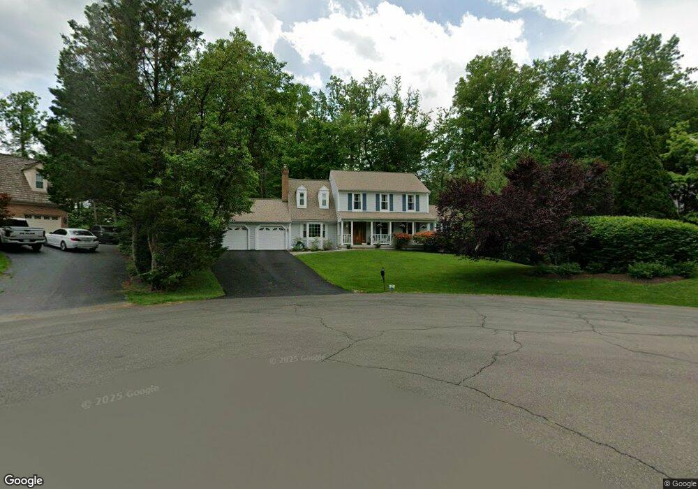
10801 Fieldwood Dr Fairfax, VA 22030
Estimated Value: $1,102,590 - $1,272,000
5
Beds
4
Baths
2,668
Sq Ft
$443/Sq Ft
Est. Value
About This Home
This home is located at 10801 Fieldwood Dr, Fairfax, VA 22030 and is currently estimated at $1,182,648, approximately $443 per square foot. 10801 Fieldwood Dr is a home located in Fairfax County with nearby schools including Oak View Elementary School, Frost Middle School, and W. T. Woodson High School.
Ownership History
Date
Name
Owned For
Owner Type
Purchase Details
Closed on
Sep 29, 1997
Sold by
Hille Rolf G and Hille Ruth M
Bought by
Flynn Daniel J and Flynn Catherine M
Current Estimated Value
Home Financials for this Owner
Home Financials are based on the most recent Mortgage that was taken out on this home.
Original Mortgage
$267,840
Outstanding Balance
$43,107
Interest Rate
7.47%
Mortgage Type
New Conventional
Estimated Equity
$1,139,541
Create a Home Valuation Report for This Property
The Home Valuation Report is an in-depth analysis detailing your home's value as well as a comparison with similar homes in the area
Home Values in the Area
Average Home Value in this Area
Purchase History
| Date | Buyer | Sale Price | Title Company |
|---|---|---|---|
| Flynn Daniel J | $223,800 | -- |
Source: Public Records
Mortgage History
| Date | Status | Borrower | Loan Amount |
|---|---|---|---|
| Open | Flynn Daniel J | $267,840 |
Source: Public Records
Tax History Compared to Growth
Tax History
| Year | Tax Paid | Tax Assessment Tax Assessment Total Assessment is a certain percentage of the fair market value that is determined by local assessors to be the total taxable value of land and additions on the property. | Land | Improvement |
|---|---|---|---|---|
| 2025 | $12,199 | $1,083,940 | $374,000 | $709,940 |
| 2024 | $12,199 | $1,053,040 | $374,000 | $679,040 |
| 2023 | $11,028 | $977,250 | $344,000 | $633,250 |
| 2022 | $9,579 | $837,650 | $294,000 | $543,650 |
| 2021 | $8,692 | $740,670 | $269,000 | $471,670 |
| 2020 | $8,694 | $734,590 | $269,000 | $465,590 |
| 2019 | $8,694 | $734,590 | $269,000 | $465,590 |
| 2018 | $8,349 | $726,010 | $269,000 | $457,010 |
| 2017 | $8,267 | $712,050 | $264,000 | $448,050 |
| 2016 | $7,951 | $686,310 | $254,000 | $432,310 |
| 2015 | $7,659 | $686,310 | $254,000 | $432,310 |
| 2014 | $7,642 | $686,310 | $254,000 | $432,310 |
Source: Public Records
Map
Nearby Homes
- 10710 Almond St
- 0 Joshua Davis Ct
- 4316 Chain Bridge Rd
- 10271 Braddock Rd
- 10255 Braddock Rd
- 10901 Santa Clara Dr
- 10212 Provincetown Ct
- 10496 Courtney Dr
- 10708 Rippon Lodge Dr
- 10404 Forest Ave
- 11317 Edenderry Dr
- 4607 Tapestry Dr
- 10919 Spurlock Ct
- 10721 West Dr Unit 302
- 10723 West Dr Unit 103
- 11123 Popes Head Rd
- 10632 Pocket Place
- 10634 Pocket Place
- 10196 Red Spruce Rd
- 4768 Farndon Ct
- 10800 Fieldwood Dr
- 10803 Fieldwood Dr
- 10805 Fieldwood Dr
- 10802 Fieldwood Dr
- 4862 Oakcrest Dr
- 4910 Ox Rd
- 10807 Fieldwood Dr
- 4864 Oakcrest Dr
- 10806 Fieldwood Dr
- 4866 Oakcrest Dr
- 4865 Oakcrest Dr
- 4867 Oakcrest Dr
- 4868 Oakcrest Dr
- 10811 Fieldwood Dr
- 4912 Ox Rd
- 4855 Slatestone Ct
- 10810 Fieldwood Dr
- 10792 Glen Mist Ln
- 4869 Oakcrest Dr
- 10790 Glen Mist Ln