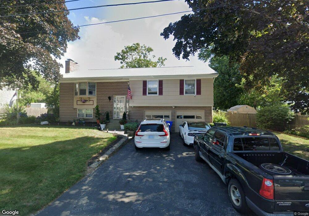
11 Milburn Rd East Providence, RI 02914
Kent Heights NeighborhoodEstimated Value: $443,907 - $526,000
3
Beds
2
Baths
1,776
Sq Ft
$270/Sq Ft
Est. Value
About This Home
This home is located at 11 Milburn Rd, East Providence, RI 02914 and is currently estimated at $480,227, approximately $270 per square foot. 11 Milburn Rd is a home located in Providence County with nearby schools including East Providence High School, The Gordon School, and St Mary Academy-Bay View.
Ownership History
Date
Name
Owned For
Owner Type
Purchase Details
Closed on
Mar 12, 2019
Sold by
Enos-Cappuccio Krista and Enos Jason R
Bought by
Enos Jeffrey T
Current Estimated Value
Home Financials for this Owner
Home Financials are based on the most recent Mortgage that was taken out on this home.
Original Mortgage
$164,000
Outstanding Balance
$143,891
Interest Rate
4.4%
Mortgage Type
New Conventional
Estimated Equity
$336,336
Create a Home Valuation Report for This Property
The Home Valuation Report is an in-depth analysis detailing your home's value as well as a comparison with similar homes in the area
Home Values in the Area
Average Home Value in this Area
Purchase History
| Date | Buyer | Sale Price | Title Company |
|---|---|---|---|
| Enos Jeffrey T | $160,000 | -- | |
| Enos Jeffrey T | $160,000 | -- |
Source: Public Records
Mortgage History
| Date | Status | Borrower | Loan Amount |
|---|---|---|---|
| Open | Enos Jeffrey T | $164,000 | |
| Closed | Enos Jeffrey T | $164,000 |
Source: Public Records
Tax History Compared to Growth
Tax History
| Year | Tax Paid | Tax Assessment Tax Assessment Total Assessment is a certain percentage of the fair market value that is determined by local assessors to be the total taxable value of land and additions on the property. | Land | Improvement |
|---|---|---|---|---|
| 2025 | $5,482 | $419,400 | $132,600 | $286,800 |
| 2024 | $5,090 | $332,000 | $110,600 | $221,400 |
| 2023 | $4,900 | $332,000 | $110,600 | $221,400 |
| 2022 | $4,731 | $216,400 | $57,600 | $158,800 |
| 2021 | $4,653 | $216,400 | $57,600 | $158,800 |
| 2020 | $4,456 | $216,400 | $57,600 | $158,800 |
| 2019 | $4,332 | $216,400 | $57,600 | $158,800 |
| 2018 | $4,205 | $183,800 | $58,900 | $124,900 |
| 2017 | $4,112 | $183,800 | $58,900 | $124,900 |
| 2016 | $4,091 | $183,800 | $58,900 | $124,900 |
| 2015 | $4,152 | $180,900 | $51,900 | $129,000 |
| 2014 | $4,152 | $180,900 | $51,900 | $129,000 |
Source: Public Records
Map
Nearby Homes
- 53 Wampanoag Trail
- 108 Ivan Ave
- 10 Fairfield Ave
- 36 Gerald St
- 59 Merritt Rd
- 180 Grassmere Ave
- 25 Ide Ave
- 87 Vincent Ave
- 74 Brookhaven Dr
- 50 Kettle Point Ave Unit 50
- 740 Veterans Memorial Pkwy
- 14 Waterview Ave Unit 16
- 1463 S Broadway
- 26 Mayflower St
- 132 S Rose St
- 75 Belmont Ave
- 17 Brown St Unit 19
- 21 Donnelly St
- 400 Juniper St Unit A
- 400 Juniper St Unit B
- 19 Milburn Rd
- 70 Wampanoag Trail
- 400 Dover Ave
- 10 Milburn Rd
- 76 Wampanoag Trail
- 16 Milburn Rd
- 404 Dover Ave
- 404 Dover Ave Unit 2
- 404 Dover Ave Unit 1
- 80 Wampanoag Trail
- 392 Dover Ave
- 20 Milburn Rd
- 82 Wampanoag Trail
- 26 Milburn Rd
- 17 Commack Rd
- 11 Commack Rd
- 388 Dover Ave
- 61 Wampanoag Trail
- 55 Wampanoag Trail
- 65 Wampanoag Trail