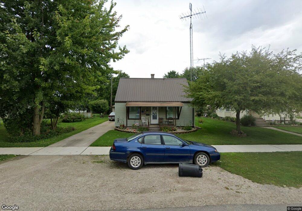
111 Elizabeth St Croswell, MI 48422
Estimated Value: $111,000 - $134,000
2
Beds
1
Bath
900
Sq Ft
$136/Sq Ft
Est. Value
About This Home
This home is located at 111 Elizabeth St, Croswell, MI 48422 and is currently estimated at $122,386, approximately $135 per square foot. 111 Elizabeth St is a home located in Sanilac County.
Ownership History
Date
Name
Owned For
Owner Type
Purchase Details
Closed on
Nov 9, 2018
Sold by
Levitt Aaron J
Bought by
Walker Annette
Current Estimated Value
Purchase Details
Closed on
Jun 29, 2018
Sold by
Swarts Cody J
Bought by
Levitt Aaron J
Purchase Details
Closed on
Jan 27, 2010
Sold by
Krzysiak Angela
Bought by
Swarts Cody J
Purchase Details
Closed on
Jul 13, 2009
Sold by
Deutsche Bank National Trust
Bought by
Krzysiak Angela
Purchase Details
Closed on
Dec 4, 2008
Sold by
Jones Emily
Bought by
First Franklin Mortgage Loan Trust 2005-
Purchase Details
Closed on
Sep 29, 2005
Sold by
Slone Donna J
Bought by
Jones Emily
Create a Home Valuation Report for This Property
The Home Valuation Report is an in-depth analysis detailing your home's value as well as a comparison with similar homes in the area
Home Values in the Area
Average Home Value in this Area
Purchase History
| Date | Buyer | Sale Price | Title Company |
|---|---|---|---|
| Walker Annette | $75,000 | -- | |
| Levitt Aaron J | $65,000 | -- | |
| Swarts Cody J | $35,000 | -- | |
| Krzysiak Angela | $29,100 | -- | |
| First Franklin Mortgage Loan Trust 2005- | $40,878 | -- | |
| Deutsche Bank National | $40,900 | -- | |
| Jones Emily | $74,000 | -- |
Source: Public Records
Tax History Compared to Growth
Tax History
| Year | Tax Paid | Tax Assessment Tax Assessment Total Assessment is a certain percentage of the fair market value that is determined by local assessors to be the total taxable value of land and additions on the property. | Land | Improvement |
|---|---|---|---|---|
| 2025 | $899 | $40,700 | $0 | $0 |
| 2024 | $645 | $36,500 | $0 | $0 |
| 2023 | $624 | $28,100 | $0 | $0 |
| 2022 | $825 | $23,300 | $0 | $0 |
| 2021 | $801 | $20,800 | $0 | $0 |
| 2020 | $791 | $21,700 | $0 | $0 |
| 2019 | $777 | $19,600 | $0 | $0 |
| 2018 | $912 | $20,700 | $0 | $0 |
| 2017 | $612 | $19,100 | $0 | $0 |
| 2016 | $438 | $16,800 | $0 | $0 |
| 2015 | -- | $17,200 | $0 | $0 |
| 2014 | -- | $15,800 | $0 | $0 |
Source: Public Records
Map
Nearby Homes
- 229 Melvin St
- 235 N Howard Ave
- 241 Anderson Ave
- 42 S Flower St
- Lot #17 Jay St
- 0 Harrington Rd Dot Street-Parcel B Unit 50032187
- Parcel E Dot St
- Parcel D Dot St
- Parcel C Dot St
- 0 Dot Unit 20251010317
- Lot 4 Red Pine Ln
- Lot 18 White Pine Ln
- Lot 16 White Pine Ln
- vac Peck Rd
- 0000 Peck Wildcat Rd
- 4405 Black River Rd
- 5393 Cedar St
- 4204 Peck Rd
- 5447 Willow Dr
- 5401 Pine St