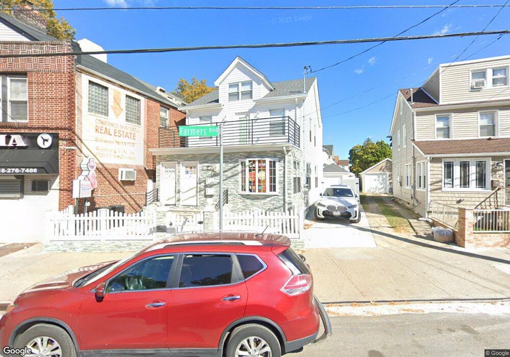
11145 Farmers Blvd Saint Albans, NY 11412
Hollis NeighborhoodEstimated Value: $800,374 - $1,373,000
--
Bed
--
Bath
2,889
Sq Ft
$356/Sq Ft
Est. Value
About This Home
This home is located at 11145 Farmers Blvd, Saint Albans, NY 11412 and is currently estimated at $1,027,594, approximately $355 per square foot. 11145 Farmers Blvd is a home located in Queens County with nearby schools including P.S. 118 Lorraine Hansberry and I.S. 192 The Linden.
Ownership History
Date
Name
Owned For
Owner Type
Purchase Details
Closed on
Jun 3, 2021
Sold by
Sls Property Management Group Llc
Bought by
Smith Sundrea
Current Estimated Value
Purchase Details
Closed on
Jan 29, 2021
Sold by
Smith Sundrea
Bought by
Sls Property Management Group Llc
Purchase Details
Closed on
Oct 15, 2020
Sold by
Smith Joy and Smith Lonzo
Bought by
Smith Sundrea
Create a Home Valuation Report for This Property
The Home Valuation Report is an in-depth analysis detailing your home's value as well as a comparison with similar homes in the area
Home Values in the Area
Average Home Value in this Area
Purchase History
| Date | Buyer | Sale Price | Title Company |
|---|---|---|---|
| Smith Sundrea | -- | -- | |
| Smith Sundrea | -- | -- | |
| Sls Property Management Group Llc | -- | -- | |
| Sls Property Management Group Llc | -- | -- | |
| Smith Sundrea | -- | -- | |
| Smith Joy | -- | -- | |
| Smith Sundrea | -- | -- | |
| Smith Joy | -- | -- |
Source: Public Records
Tax History Compared to Growth
Tax History
| Year | Tax Paid | Tax Assessment Tax Assessment Total Assessment is a certain percentage of the fair market value that is determined by local assessors to be the total taxable value of land and additions on the property. | Land | Improvement |
|---|---|---|---|---|
| 2025 | $6,964 | $34,902 | $10,815 | $24,087 |
| 2024 | $6,964 | $34,671 | $11,356 | $23,315 |
| 2023 | $5,297 | $26,375 | $9,933 | $16,442 |
| 2022 | $4,184 | $41,340 | $15,840 | $25,500 |
| 2021 | $5,237 | $37,980 | $15,840 | $22,140 |
| 2020 | $3,746 | $37,080 | $15,840 | $21,240 |
| 2019 | $2,018 | $33,960 | $15,840 | $18,120 |
| 2018 | $1,842 | $21,979 | $12,293 | $9,686 |
| 2017 | $3,316 | $20,736 | $12,357 | $8,379 |
| 2016 | $3,261 | $20,736 | $12,357 | $8,379 |
| 2015 | $1,792 | $19,573 | $10,351 | $9,222 |
| 2014 | $1,792 | $19,414 | $12,308 | $7,106 |
Source: Public Records
Map
Nearby Homes
- 19022 111th Rd
- 190-59 112th Ave
- 111-06 Farmers Blvd
- 190-63 112th Ave
- 191-40 112th Rd
- 188-31 Jordan Ave
- 18833 Keeseville Ave
- 194-16 112th Ave
- 187-44 Jordan Ave
- 19404 110th Rd
- 194- 24 111th Rd
- 188-25 Mangin Ave
- 194-29 112th Ave
- 18823 Mangin Ave
- 188-07 Mangin Ave
- 193-21 109th Rd
- 19027 109th Rd
- 186-16 Hilburn Ave
- 10533 Farmers Blvd
- 18908 114th Rd
- 11141 Farmers Blvd
- 111-41 Farmers Blvd Unit 2
- 111-41 Farmers Blvd
- 11149 Farmers Blvd
- 111-49 Farmers Blvd
- 19018 111th Rd
- 11135 Farmers Blvd
- 11153 Farmers Blvd
- 190-22 111th Rd
- 19022 111th Rd
- 190-15 111th Rd
- 19009 111th Rd
- 111-35 Farmers Blvd
- 19013 111th Rd
- 11131 Farmers Blvd
- 19015 111th Rd
- 111-31 Farmers Blvd
- 19024 111th Rd
- 11157 Farmers Blvd
- 190-19 111th Rd