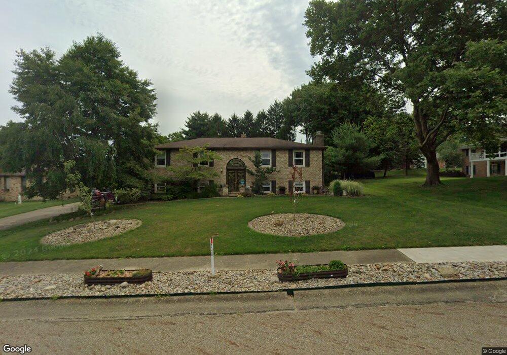
1130 Century Hill St Louisville, OH 44641
Estimated Value: $262,579 - $294,000
3
Beds
2
Baths
1,456
Sq Ft
$192/Sq Ft
Est. Value
About This Home
This home is located at 1130 Century Hill St, Louisville, OH 44641 and is currently estimated at $278,895, approximately $191 per square foot. 1130 Century Hill St is a home located in Stark County with nearby schools including Louisville High School and St. Thomas Aquinas High School & Middle School.
Ownership History
Date
Name
Owned For
Owner Type
Purchase Details
Closed on
Nov 22, 2013
Sold by
Clymore Pamela K
Bought by
Clymore Pamela K
Current Estimated Value
Purchase Details
Closed on
Jan 12, 1996
Sold by
Olland Herbert H
Bought by
Clymore Daniel B and Clymore Pamela
Purchase Details
Closed on
Nov 22, 1988
Create a Home Valuation Report for This Property
The Home Valuation Report is an in-depth analysis detailing your home's value as well as a comparison with similar homes in the area
Home Values in the Area
Average Home Value in this Area
Purchase History
| Date | Buyer | Sale Price | Title Company |
|---|---|---|---|
| Clymore Pamela K | -- | None Available | |
| Clymore Daniel B | $135,000 | -- | |
| -- | $86,000 | -- |
Source: Public Records
Tax History Compared to Growth
Tax History
| Year | Tax Paid | Tax Assessment Tax Assessment Total Assessment is a certain percentage of the fair market value that is determined by local assessors to be the total taxable value of land and additions on the property. | Land | Improvement |
|---|---|---|---|---|
| 2025 | -- | $84,250 | $17,120 | $67,130 |
| 2024 | -- | $84,250 | $17,120 | $67,130 |
| 2023 | $2,640 | $70,600 | $16,140 | $54,460 |
| 2022 | $2,664 | $70,600 | $16,140 | $54,460 |
| 2021 | $2,671 | $70,600 | $16,140 | $54,460 |
| 2020 | $2,186 | $63,710 | $14,530 | $49,180 |
| 2019 | $2,183 | $63,570 | $14,390 | $49,180 |
| 2018 | $2,181 | $63,570 | $14,390 | $49,180 |
| 2017 | $1,953 | $56,110 | $12,640 | $43,470 |
| 2016 | $1,993 | $56,110 | $12,640 | $43,470 |
| 2015 | $1,999 | $56,110 | $12,640 | $43,470 |
| 2014 | $1,804 | $48,480 | $10,920 | $37,560 |
| 2013 | $906 | $48,480 | $10,920 | $37,560 |
Source: Public Records
Map
Nearby Homes
- 2110 Edmar St
- 1812 E Broad St
- 1715 High St
- 3390 Meese Rd NE
- 2015 E Main St
- 641 S Nickelplate St
- 308 Superior St
- 520 S Silver St
- 908 Sand Lot Cir
- 0 Michigan Blvd
- 728 E Broad St
- 8225 Georgetown St
- 510 S Bauman Ct
- 204 E Broad St
- 107 E Broad St
- 325 Lincoln Ave
- 1170 Winding Ridge Ave
- 1702 View Pointe Ave
- 1639 Horizon Dr
- 910 Crosswyck Cir
- 1100 Century Hill St
- 2207 Edmar St
- 2219 Edmar St
- 1090 Century Hill St
- 1976 Opal St
- 2131 Edmar St
- 1113 Meese Rd
- 1977 Opal St
- 1076 Century Hill St
- 1011 Meese Rd NE
- 1966 Opal St
- 1125 Meese Rd
- 1025 Meese Rd
- 2125 Edmar St
- 1208 Century Hill St
- 2218 Edmar St
- 1967 Opal St
- 1064 Century Hill St
- 1956 Opal St
- 2230 Edmar St