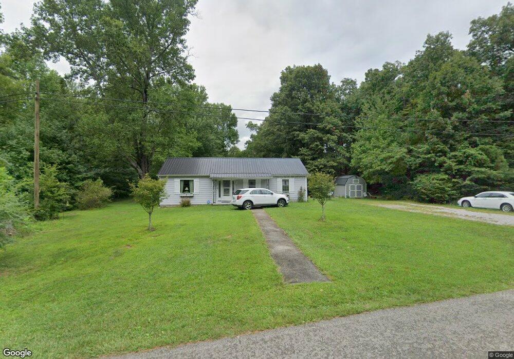
1139 Old Bon Air Rd Sparta, TN 38583
Estimated Value: $105,019 - $159,000
--
Bed
1
Bath
767
Sq Ft
$163/Sq Ft
Est. Value
About This Home
This home is located at 1139 Old Bon Air Rd, Sparta, TN 38583 and is currently estimated at $125,005, approximately $162 per square foot. 1139 Old Bon Air Rd is a home located in White County with nearby schools including Bon De Croft Elementary School, White County Middle School, and White County High School.
Ownership History
Date
Name
Owned For
Owner Type
Purchase Details
Closed on
Aug 21, 2015
Sold by
Thedford Kimberly Ann
Bought by
Baker Barry and Baker Rita
Current Estimated Value
Purchase Details
Closed on
May 3, 2013
Sold by
Hensley Harold F
Bought by
Thedford Kimberly Ann
Purchase Details
Closed on
Apr 23, 1981
Bought by
Hensley Harold F and Hensley Lois
Purchase Details
Closed on
Jan 1, 1981
Create a Home Valuation Report for This Property
The Home Valuation Report is an in-depth analysis detailing your home's value as well as a comparison with similar homes in the area
Home Values in the Area
Average Home Value in this Area
Purchase History
| Date | Buyer | Sale Price | Title Company |
|---|---|---|---|
| Baker Barry | $35,000 | -- | |
| Thedford Kimberly Ann | -- | -- | |
| Hensley Harold F | -- | -- | |
| -- | $9,000 | -- |
Source: Public Records
Tax History Compared to Growth
Tax History
| Year | Tax Paid | Tax Assessment Tax Assessment Total Assessment is a certain percentage of the fair market value that is determined by local assessors to be the total taxable value of land and additions on the property. | Land | Improvement |
|---|---|---|---|---|
| 2024 | $279 | $13,625 | $2,975 | $10,650 |
| 2023 | $279 | $13,625 | $2,975 | $10,650 |
| 2022 | $279 | $13,625 | $2,975 | $10,650 |
| 2021 | $279 | $13,625 | $2,975 | $10,650 |
| 2020 | $279 | $13,625 | $2,975 | $10,650 |
| 2019 | $182 | $8,875 | $2,450 | $6,425 |
| 2018 | $182 | $8,875 | $2,450 | $6,425 |
| 2017 | $182 | $8,875 | $2,450 | $6,425 |
| 2016 | $182 | $8,875 | $2,450 | $6,425 |
| 2015 | $164 | $8,875 | $2,450 | $6,425 |
| 2014 | -- | $8,875 | $2,450 | $6,425 |
| 2013 | -- | $8,450 | $2,450 | $6,000 |
Source: Public Records
Map
Nearby Homes
- 0 Old Bon Air Rd
- 450 Low Gap Rd
- 708 Low Gap Rd
- 319 Grandview Dr
- 5185 Crossville Hwy
- 0 Vandy Cir
- 171 Brush Wood Dr
- 3908 Lost Creek Rd
- 2365 Crossville Hwy
- 00 Lost Creek Rd
- Tract 1 Wildcat Cove Rd
- 5928 Crossville Hwy
- 1.8ac Baker Mountain Rd
- 397 Wildcat Cove Rd
- 198 Johnson St
- 6232 Crossville Hwy
- 214 Holiday Ln
- 1269 Old Bon Air Rd
- 1281 Old Bon Air Rd
- 1457 Old Bon Air Rd
- 1471 Old Bon Air Rd
- 1485 Old Bon Air Rd
- 1423 Old Bon Air Rd
- 520 Holman Rd
- 1499 Old Bonair Rd
- 1513 Old Bon Air Rd
- 1527 Old Bonair Rd
- 516 Old Bon Air Rd
- 516 Old Bonair Rd
- 1510 Old Bon Air Rd
- 484 Old Bon Air Rd
- 693 Holman Rd
- 1561 Old Bon Air Rd
- 715 Holman Rd
- 400 Old Bon Air Rd
- 1586 Old Bon Air Rd
- 1615 Old Bon Air Rd