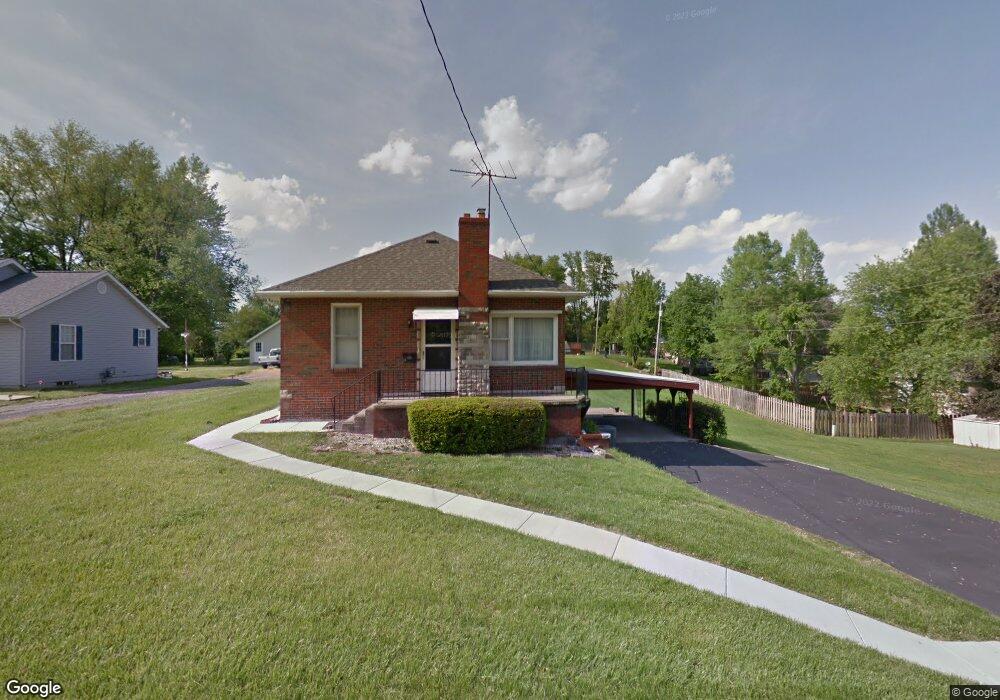
114 Brennan Ave Collinsville, IL 62234
Estimated Value: $128,551 - $159,000
4
Beds
1
Bath
895
Sq Ft
$158/Sq Ft
Est. Value
About This Home
This home is located at 114 Brennan Ave, Collinsville, IL 62234 and is currently estimated at $141,388, approximately $157 per square foot. 114 Brennan Ave is a home located in Madison County with nearby schools including John A Renfro Elementary School, Dorris Intermediate School, and Collinsville Middle School.
Ownership History
Date
Name
Owned For
Owner Type
Purchase Details
Closed on
Apr 12, 2024
Sold by
Lecuyer James R and Elizabeth Roach Estate Elizabeth Roach Estate
Bought by
Lecuyer James R
Current Estimated Value
Purchase Details
Closed on
Jun 21, 2018
Sold by
Lecuyer Elyse R
Bought by
Lecuyer James R
Purchase Details
Closed on
Jul 3, 2003
Sold by
Roach Elizabeth and Roach Roseann
Bought by
Cuyer James Le and Cuyer Elyse Le
Create a Home Valuation Report for This Property
The Home Valuation Report is an in-depth analysis detailing your home's value as well as a comparison with similar homes in the area
Home Values in the Area
Average Home Value in this Area
Purchase History
| Date | Buyer | Sale Price | Title Company |
|---|---|---|---|
| Lecuyer James R | -- | None Available | |
| Lecuyer James R | -- | None Available | |
| Cuyer James Le | -- | -- |
Source: Public Records
Tax History Compared to Growth
Tax History
| Year | Tax Paid | Tax Assessment Tax Assessment Total Assessment is a certain percentage of the fair market value that is determined by local assessors to be the total taxable value of land and additions on the property. | Land | Improvement |
|---|---|---|---|---|
| 2024 | $2,271 | $35,520 | $7,200 | $28,320 |
| 2023 | $2,163 | $32,870 | $6,660 | $26,210 |
| 2022 | $2,163 | $29,470 | $5,960 | $23,510 |
| 2021 | $1,498 | $27,690 | $5,600 | $22,090 |
| 2020 | $1,425 | $26,420 | $5,340 | $21,080 |
| 2019 | $231 | $25,520 | $5,160 | $20,360 |
| 2018 | $234 | $22,880 | $5,220 | $17,660 |
| 2017 | $865 | $22,430 | $5,120 | $17,310 |
| 2016 | $257 | $22,430 | $5,120 | $17,310 |
| 2015 | $246 | $21,850 | $4,990 | $16,860 |
| 2014 | $246 | $21,850 | $4,990 | $16,860 |
| 2013 | $246 | $21,850 | $4,990 | $16,860 |
Source: Public Records
Map
Nearby Homes
- 1224 Cedar Ridge Ct
- 308 Brown Ave
- 1120 Williams St
- 617 N Morrison Ave
- 1210 Constance St
- 22 Brookwood Dr
- 5 Brookwood Dr
- 414 Bunker Hill Dr
- 123 W Wickliffe Ave
- 0 Strong Ave
- 123 Elliot St
- 203 Greenfield Dr
- 501 Spring
- 0 N Keebler Ave
- 580 N Guernsey St
- 510 N Combs Ave
- 919 Vine St
- 0 Elm St
- 1121 Carraway Ct
- 921 Prospect St
- 1009 N Center St
- 1005 N Center St
- 1007 N Center St
- 115A Clark St
- 1010 Virginia St
- 115 Clark St Unit A
- 115 Clark St
- 109 Clark St
- 107 Clark St
- 1003 N Center St
- 116 Brennan Ave
- 1102 Virginia St
- 1012 N Center St
- 124 Brennan Ave
- 1104 Virginia St
- 1010 N Center St
- 1001 N Center St
- 1100 N Center St
- 1106 Virginia St
- 1108 Virginia St