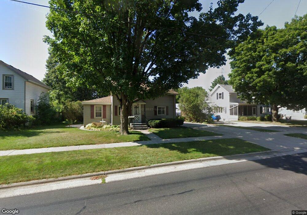
1142 River Dr Watertown, WI 53094
Estimated Value: $203,756 - $247,000
3
Beds
1
Bath
1,014
Sq Ft
$221/Sq Ft
Est. Value
About This Home
This home is located at 1142 River Dr, Watertown, WI 53094 and is currently estimated at $224,189, approximately $221 per square foot. 1142 River Dr is a home located in Jefferson County with nearby schools including Watertown High School, eCampus Academy Charter School, and Trinity-St. Luke's Lutheran Elementary School.
Ownership History
Date
Name
Owned For
Owner Type
Purchase Details
Closed on
Jun 30, 2011
Sold by
Wallace Carol
Bought by
Schoenike Michele D
Current Estimated Value
Home Financials for this Owner
Home Financials are based on the most recent Mortgage that was taken out on this home.
Original Mortgage
$28,900
Outstanding Balance
$19,995
Interest Rate
4.63%
Mortgage Type
New Conventional
Estimated Equity
$204,194
Create a Home Valuation Report for This Property
The Home Valuation Report is an in-depth analysis detailing your home's value as well as a comparison with similar homes in the area
Home Values in the Area
Average Home Value in this Area
Purchase History
| Date | Buyer | Sale Price | Title Company |
|---|---|---|---|
| Schoenike Michele D | $63,900 | Knight Barry Title Inc |
Source: Public Records
Mortgage History
| Date | Status | Borrower | Loan Amount |
|---|---|---|---|
| Open | Schoenike Michele D | $28,900 |
Source: Public Records
Tax History Compared to Growth
Tax History
| Year | Tax Paid | Tax Assessment Tax Assessment Total Assessment is a certain percentage of the fair market value that is determined by local assessors to be the total taxable value of land and additions on the property. | Land | Improvement |
|---|---|---|---|---|
| 2024 | $2,298 | $155,800 | $53,400 | $102,400 |
| 2023 | $2,188 | $124,900 | $47,400 | $77,500 |
| 2022 | $1,992 | $124,900 | $47,400 | $77,500 |
| 2021 | $1,698 | $77,000 | $30,000 | $47,000 |
| 2020 | $1,758 | $77,000 | $30,000 | $47,000 |
| 2019 | $1,692 | $77,000 | $30,000 | $47,000 |
| 2018 | $1,665 | $77,000 | $30,000 | $47,000 |
| 2017 | $1,619 | $77,000 | $30,000 | $47,000 |
| 2016 | $1,590 | $77,000 | $30,000 | $47,000 |
| 2015 | $1,684 | $77,000 | $30,000 | $47,000 |
| 2014 | $1,707 | $77,000 | $30,000 | $47,000 |
| 2013 | $1,738 | $77,000 | $30,000 | $47,000 |
Source: Public Records
Map
Nearby Homes
- 1215 Utah St
- 1301 Utah St
- 1313 Utah St
- 913 S 3rd St
- 1314 Waldron St
- 131 Cedar Ct
- The Saybrook Plan at Rock River Ridge
- The Atwater Plan at Rock River Ridge
- The Hudson Plan at Rock River Ridge
- The Coral Plan at Rock River Ridge
- The Drake Plan at Rock River Ridge
- The Addison Plan at Rock River Ridge
- The Bradford Plan at Rock River Ridge
- The Catalina Plan at Rock River Ridge
- The Adrian Plan at Rock River Ridge
- The McKinley Plan at Rock River Ridge
- The Siena Plan at Rock River Ridge
- The Bridgeport Plan at Rock River Ridge
- The Wingra Plan at Rock River Ridge
- The Conway Plan at Rock River Ridge