Estimated Value: $190,000 - $357,000
3
Beds
3
Baths
1,744
Sq Ft
$159/Sq Ft
Est. Value
About This Home
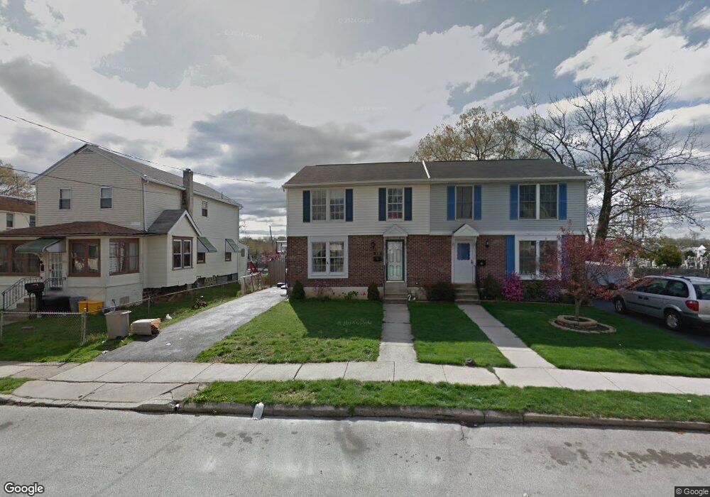
This home is located at 1158 Broad St, Darby, PA 19023 and is currently estimated at $277,673, approximately $159 per square foot. 1158 Broad St is a home located in Delaware County with nearby schools including Darby Township School, Academy Park High School, and Liberty Baptist Academy.
Ownership History
Date
Name
Owned For
Owner Type
Purchase Details
Closed on
Apr 26, 2005
Sold by
Hud and Armstrong Carole
Bought by
Dearros Theresa M
Current Estimated Value
Home Financials for this Owner
Home Financials are based on the most recent Mortgage that was taken out on this home.
Original Mortgage
$107,350
Outstanding Balance
$56,368
Interest Rate
5.95%
Mortgage Type
Fannie Mae Freddie Mac
Estimated Equity
$221,305
Purchase Details
Closed on
Feb 1, 2005
Sold by
Principal Residential Mortgage Inc and Ferrer Nora
Bought by
Hud
Purchase Details
Closed on
Nov 30, 2004
Sold by
Ballak Phillip P and Ballak Deborah A
Bought by
Principal Residential Mortgage Inc
Purchase Details
Closed on
Jun 4, 1999
Sold by
Hirst Daniel T and Hirst Catherine Kime
Bought by
Ballak Ii Philip P and Ballak Deborah A
Home Financials for this Owner
Home Financials are based on the most recent Mortgage that was taken out on this home.
Original Mortgage
$94,719
Interest Rate
6.99%
Mortgage Type
FHA
Create a Home Valuation Report for This Property
The Home Valuation Report is an in-depth analysis detailing your home's value as well as a comparison with similar homes in the area
Home Values in the Area
Average Home Value in this Area
Purchase History
| Date | Buyer | Sale Price | Title Company |
|---|---|---|---|
| Dearros Theresa M | $113,000 | -- | |
| Hud | -- | -- | |
| Principal Residential Mortgage Inc | -- | -- | |
| Ballak Ii Philip P | $95,500 | Commonwealth Land Title Ins |
Source: Public Records
Mortgage History
| Date | Status | Borrower | Loan Amount |
|---|---|---|---|
| Open | Dearros Theresa M | $107,350 | |
| Previous Owner | Ballak Ii Philip P | $94,719 |
Source: Public Records
Tax History Compared to Growth
Tax History
| Year | Tax Paid | Tax Assessment Tax Assessment Total Assessment is a certain percentage of the fair market value that is determined by local assessors to be the total taxable value of land and additions on the property. | Land | Improvement |
|---|---|---|---|---|
| 2025 | $6,167 | $136,170 | $23,790 | $112,380 |
| 2024 | $6,167 | $136,170 | $23,790 | $112,380 |
| 2023 | $6,003 | $136,170 | $23,790 | $112,380 |
| 2022 | $5,775 | $136,170 | $23,790 | $112,380 |
| 2021 | $7,954 | $136,170 | $23,790 | $112,380 |
| 2020 | $6,528 | $102,690 | $19,590 | $83,100 |
| 2019 | $6,292 | $102,690 | $19,590 | $83,100 |
| 2018 | $6,153 | $102,690 | $0 | $0 |
| 2017 | $6,038 | $102,690 | $0 | $0 |
| 2016 | $564 | $102,690 | $0 | $0 |
| 2015 | $564 | $102,690 | $0 | $0 |
| 2014 | $564 | $102,690 | $0 | $0 |
Source: Public Records
Map
Nearby Homes
- 1119 Chestnut St
- 539 Pershing Ave
- 402 Rively Ave
- 1018 Broad St
- 653 Rively Ave
- 909 Walnut St
- 631 Beech Ave
- 933 Bedford Ave
- 921 Pitman Ave
- 924 Pitman Ave
- 719 Beech Ave
- 1025 Andrews Ave
- 1011 Andrews Ave
- 815 Clifton Ave
- 1011 Clifton Ave
- 108 S Clifton Ave
- 662 S Oak Ave
- 821 Lawnton Terrace
- 900 Maple Ave
- 222 Collingdale Ave