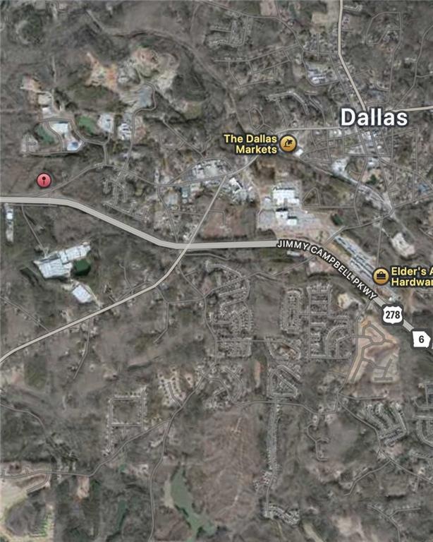


1160 W Memorial Dr Dallas, GA 30132
Estimated payment $2,178/month
Highlights
- View of Trees or Woods
- 4.47 Acre Lot
- Wooded Lot
About This Lot
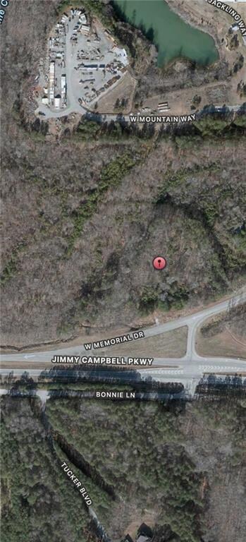
4.47± Acres – PRIVATE HOMESTEAD or Light Industrial / Commercial Development Opportunity in Paulding County, GA
This 4.47± acre parcel at 1160 W Memorial Drive offers a rare, shovel-ready vision for transformation into a light industrial and commercial hub. Currently zoned R-2 (Suburban Residential), the property has strong potential for rezoning to I-2, unlocking opportunities for small warehouses, drive-thru retail, and other light commercial uses.
The concept master plan seen in the photos envisions:
42,000± sq ft of warehouse space across multiple 1,500–2,500 sq ft units
4,800± sq ft of commercial space, including an 800 sq ft drive-thru shop and a 4,000 sq ft retail package store
Ample parking with 77 planned spaces (exceeding county requirements)
Strategic placement for billboard advertising along Memorial Drive and Hwy 278
Engineered detention pond and state waters buffer compliance for environmental stewardship
Located inside Paulding County (not the City of Dallas), the property benefits from lower taxes while maintaining close proximity to major corridors, retail centers, and residential neighborhoods. High traffic counts along Hwy 278 make this site ideal for businesses targeting both commuter and local markets.
Whether pursued as a multi-tenant industrial park, mixed-use commercial complex, or single-user facility, this property delivers exceptional location, infrastructure potential, and growth upside.

Property Details
Property Type
- Land
Est. Annual Taxes
- $885
Lot Details
- 4.47 Acre Lot
- Property fronts a highway
- Wooded Lot
- Landscaped with Trees
- Property is zoned R-2
Property Views
- Views of Woods
Schools
- Dallas Elementary School
Listing and Financial Details
- Tax Lot Land
- Assessor Parcel Number 000264
Map
Home Values in the Area
Average Home Value in this Area
Tax History
| Year | Tax Paid | Tax Assessment Tax Assessment Total Assessment is a certain percentage of the fair market value that is determined by local assessors to be the total taxable value of land and additions on the property. | Land | Improvement |
|---|---|---|---|---|
| 2024 | $869 | $34,920 | $34,920 | -- |
| 2023 | $879 | $33,720 | $33,720 | $0 |
| 2022 | $802 | $30,760 | $30,760 | $0 |
| 2021 | $673 | $23,160 | $23,160 | $0 |
| 2020 | $715 | $24,080 | $24,080 | $0 |
| 2019 | $745 | $24,720 | $24,720 | $0 |
| 2018 | $716 | $23,760 | $23,760 | $0 |
| 2017 | $726 | $23,760 | $23,760 | $0 |
| 2016 | $683 | $22,600 | $22,600 | $0 |
| 2015 | $622 | $20,200 | $20,200 | $0 |
| 2014 | $607 | $19,240 | $19,240 | $0 |
| 2013 | -- | $22,120 | $21,360 | $760 |
Property History
| Date | Event | Price | List to Sale | Price per Sq Ft |
|---|---|---|---|---|
| 08/13/2025 08/13/25 | For Sale | $400,000 | -- | -- |
Purchase History
| Date | Type | Sale Price | Title Company |
|---|---|---|---|
| Warranty Deed | $142,500 | -- | |
| Deed | $120,000 | -- |
Mortgage History
| Date | Status | Loan Amount | Loan Type |
|---|---|---|---|
| Previous Owner | $119,939 | FHA |
Source: First Multiple Listing Service (FMLS)
MLS Number: 7630162
APN: 136.1.2.004.0000
Disclaimer: Certain information contained herein is derived from information provided by parties other than Homes.com. All information provided is deemed reliable, but is not guaranteed to be accurate and should be independently verified.
![]() Listings identified with the FMLS IDX logo come from FMLS and are held by brokerage firms other than the owner of this website. The listing brokerage is identified in any listing details. Information is deemed reliable but is not guaranteed. If you believe any FMLS listing contains material that infringes your copyrighted work please visit www.fmls.com/dmca to review our DMCA policy and learn how to submit a takedown request. © 2025 First Multiple Listing Service, Inc.
Listings identified with the FMLS IDX logo come from FMLS and are held by brokerage firms other than the owner of this website. The listing brokerage is identified in any listing details. Information is deemed reliable but is not guaranteed. If you believe any FMLS listing contains material that infringes your copyrighted work please visit www.fmls.com/dmca to review our DMCA policy and learn how to submit a takedown request. © 2025 First Multiple Listing Service, Inc.
- 105 Ashford Dr
- 107 Salem Place
- 451 Lone Bear Path
- 60 Westside Cir
- 380 Buchanan Hwy
- 298 Buchanan Hwy
- 0 Cole Lake Rd Unit 10607141
- 0 Cole Lake Rd Unit 7651259
- 196 Pope Place
- 233 E Skyline View
- 10 A C Dr
- 1119 W Memorial Dr
- The Coleman Plan at Oakmont
- The Harrington Plan at Oakmont
- The McGinnis Plan at Oakmont
- The Bradley Plan at Oakmont
- The Benson II Plan at Oakmont
- The James Plan at Oakmont
- The Caldwell Plan at Oakmont
- 236 E Skyline View
- 102 Ashford Dr
- 112 Brentwood Ct
- 119 Overlook Ct
- 109 E Skyline View
- 309 Westwood Ct
- 129 Rosewood Dr
- 118 Bradford Ct
- 206 W Bridge Park
- 107 Bradford Ct
- 303 Cole Creek Dr
- 305 Cole Creek Dr
- 326 Providence Rd
- 107 Omega Ct
- 230 Mcbee Place
- 234 Mcbee Place
- 529 S Fortune Way
- 137 St Ann Cir
- 351 W Memorial Dr
- 173 St Ann Cir
- 213 N Fortune Way