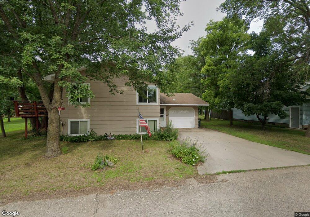
119 Elm Ave SW Richmond, MN 56368
Estimated Value: $214,000 - $245,000
3
Beds
2
Baths
813
Sq Ft
$275/Sq Ft
Est. Value
About This Home
This home is located at 119 Elm Ave SW, Richmond, MN 56368 and is currently estimated at $223,377, approximately $274 per square foot. 119 Elm Ave SW is a home located in Stearns County with nearby schools including Rocori Senior High School and Saints Peter & Paul Catholic School.
Ownership History
Date
Name
Owned For
Owner Type
Purchase Details
Closed on
Jul 16, 2015
Sold by
Snyder Angela M,Etal
Bought by
Merchant Brittney,Andrew
Current Estimated Value
Purchase Details
Closed on
Apr 19, 2013
Sold by
Tri County Exchange Llc
Bought by
Brockner Luann and Brockner Angela M
Purchase Details
Closed on
Aug 3, 2011
Sold by
Federal Home Loan Mortgage
Bought by
Jennings Bryan
Create a Home Valuation Report for This Property
The Home Valuation Report is an in-depth analysis detailing your home's value as well as a comparison with similar homes in the area
Home Values in the Area
Average Home Value in this Area
Purchase History
| Date | Buyer | Sale Price | Title Company |
|---|---|---|---|
| Merchant Brittney,Andrew | $122,000 | -- | |
| Brockner Luann | $112,900 | -- | |
| Jennings Bryan | $60,100 | -- |
Source: Public Records
Tax History Compared to Growth
Tax History
| Year | Tax Paid | Tax Assessment Tax Assessment Total Assessment is a certain percentage of the fair market value that is determined by local assessors to be the total taxable value of land and additions on the property. | Land | Improvement |
|---|---|---|---|---|
| 2025 | $1,758 | $176,300 | $27,000 | $149,300 |
| 2024 | $1,758 | $162,300 | $27,000 | $135,300 |
| 2023 | $1,532 | $148,500 | $24,900 | $123,600 |
| 2022 | $1,440 | $120,000 | $22,700 | $97,300 |
| 2021 | $1,410 | $120,000 | $22,700 | $97,300 |
| 2020 | $1,370 | $116,600 | $22,700 | $93,900 |
| 2019 | $1,272 | $110,400 | $20,900 | $89,500 |
| 2018 | $1,212 | $97,400 | $19,500 | $77,900 |
| 2017 | $1,124 | $91,800 | $19,500 | $72,300 |
| 2016 | $1,124 | $0 | $0 | $0 |
| 2015 | $1,052 | $0 | $0 | $0 |
| 2014 | -- | $0 | $0 | $0 |
Source: Public Records
Map
Nearby Homes
- 261 Main St W
- 205 Grant Ave SW
- 577 Main St W
- 148 Main St W
- 153 Central Ave S
- 101 Barry Loop NW
- 232 Main St E
- 22296 Hall Ave SW
- XXX Eastfield Dr
- 448 1st St NE
- 464 Main St E
- 21107 State Highway 23
- 22579 Fordham Rd
- 20734 Black Cherry Dr
- 21312 State Highway 22 #4
- 21312 State Highway 22 Unit 20
- 21312 State Highway 22 Unit 25
- 22314 Mallard Ct
- 20554 Elkview Ct
- 20568 Elkview Ct
- 119 119 Elm-Avenue-sw
- 416 1st St SW
- 453 1st St SW
- 104 Elm Ave SW
- 151 Elm Ave SW
- 104 104 Elm-Avenue-sw
- 152 Dutch Ave SW
- 362 2nd St SW
- 134 Elm Ave SW
- 352 2nd St S
- 29 Elm Ave SW
- 341 1st St SW
- 400 400 1st-Avenue-sw
- 342 2nd St SW
- 460 1st St SW
- 360 1st St SW Unit 584
- 145 Fir Ave SW
- 441 Main St W
- 153 Dutch Ave SW
- 57 Fir Ave SW