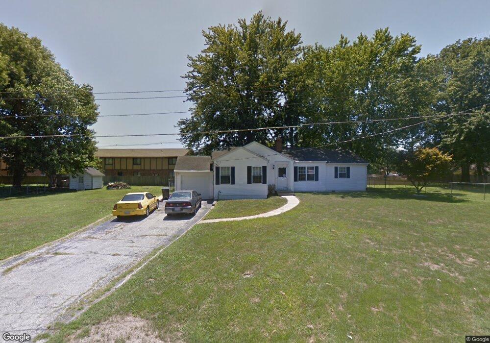
12 Lawndale Dr Belleville, IL 62221
Estimated Value: $171,496 - $185,000
--
Bed
--
Bath
1,006
Sq Ft
$177/Sq Ft
Est. Value
About This Home
This home is located at 12 Lawndale Dr, Belleville, IL 62221 and is currently estimated at $177,624, approximately $176 per square foot. 12 Lawndale Dr is a home located in St. Clair County with nearby schools including Belle Valley Elementary School-North, Zion Lutheran School Belleville, and St Teresa Catholic School.
Ownership History
Date
Name
Owned For
Owner Type
Purchase Details
Closed on
Nov 18, 2005
Sold by
Sellers Shane J and Sellers Amy H
Bought by
Tolley James C
Current Estimated Value
Home Financials for this Owner
Home Financials are based on the most recent Mortgage that was taken out on this home.
Original Mortgage
$108,000
Outstanding Balance
$59,175
Interest Rate
6.04%
Mortgage Type
Fannie Mae Freddie Mac
Estimated Equity
$118,449
Purchase Details
Closed on
Oct 30, 2003
Sold by
Siebert Allen J and Siebert Trudy A
Bought by
Sellers Shane J and Sellers Amy
Home Financials for this Owner
Home Financials are based on the most recent Mortgage that was taken out on this home.
Original Mortgage
$78,795
Interest Rate
6.04%
Mortgage Type
FHA
Create a Home Valuation Report for This Property
The Home Valuation Report is an in-depth analysis detailing your home's value as well as a comparison with similar homes in the area
Home Values in the Area
Average Home Value in this Area
Purchase History
| Date | Buyer | Sale Price | Title Company |
|---|---|---|---|
| Tolley James C | $120,000 | Town & Country Title Co | |
| Sellers Shane J | $79,500 | -- |
Source: Public Records
Mortgage History
| Date | Status | Borrower | Loan Amount |
|---|---|---|---|
| Open | Tolley James C | $108,000 | |
| Previous Owner | Sellers Shane J | $78,795 |
Source: Public Records
Tax History Compared to Growth
Tax History
| Year | Tax Paid | Tax Assessment Tax Assessment Total Assessment is a certain percentage of the fair market value that is determined by local assessors to be the total taxable value of land and additions on the property. | Land | Improvement |
|---|---|---|---|---|
| 2024 | $3,327 | $45,357 | $9,130 | $36,227 |
| 2023 | $3,110 | $41,917 | $9,004 | $32,913 |
| 2022 | $2,912 | $38,175 | $8,200 | $29,975 |
| 2021 | $2,859 | $36,608 | $7,863 | $28,745 |
| 2020 | $2,783 | $34,093 | $7,323 | $26,770 |
| 2019 | $2,440 | $31,212 | $7,996 | $23,216 |
| 2018 | $2,343 | $30,415 | $7,792 | $22,623 |
| 2017 | $2,276 | $29,605 | $7,584 | $22,021 |
| 2016 | $2,272 | $28,585 | $7,323 | $21,262 |
| 2014 | $1,991 | $28,140 | $7,062 | $21,078 |
| 2013 | $2,266 | $28,140 | $7,062 | $21,078 |
Source: Public Records
Map
Nearby Homes
- 747 Farragut Ct
- 0 Denvershire Dr
- 58 Shady Ln
- 300 Todd Ln
- 1301 Springfield Dr
- 3313 Denvershire Dr
- 405 Todd Ln
- 113 Orchard Dr
- 372 Roanoke Dr
- 340 Roanoke Dr
- 650 Fort Henry Rd
- 1420 Vicksburg Dr
- 3335 Dovershire Dr
- 1828 West Blvd Unit B
- 2077 Camrose Green St
- 2073 Camrose Green St
- 2069 Camrose Green St
- 2065 Camrose Green St
- 2061 Camrose Green St
- 2057 Camrose Green St