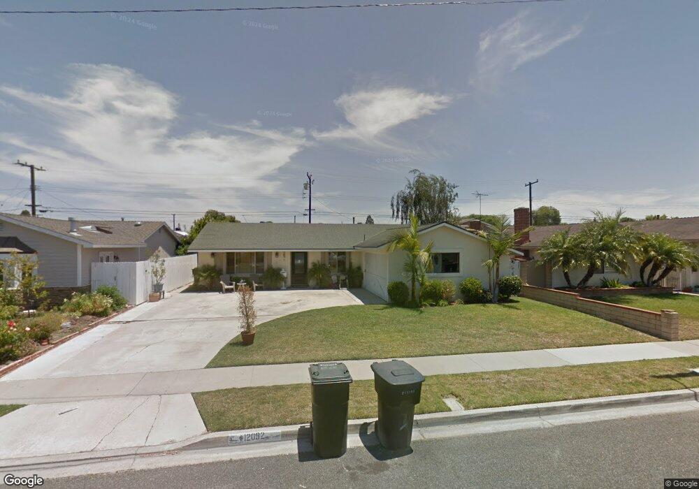
12092 Tunstall St Garden Grove, CA 92845
West Garden Grove NeighborhoodEstimated Value: $862,000 - $1,102,000
3
Beds
2
Baths
1,213
Sq Ft
$825/Sq Ft
Est. Value
About This Home
This home is located at 12092 Tunstall St, Garden Grove, CA 92845 and is currently estimated at $1,000,939, approximately $825 per square foot. 12092 Tunstall St is a home located in Orange County with nearby schools including Enders Elementary School, Hilton D. Bell Intermediate School, and Pacifica High School.
Ownership History
Date
Name
Owned For
Owner Type
Purchase Details
Closed on
Dec 21, 1993
Sold by
Mitchell Jim Frank
Bought by
Mitchell Jim Frank
Current Estimated Value
Home Financials for this Owner
Home Financials are based on the most recent Mortgage that was taken out on this home.
Original Mortgage
$100,000
Interest Rate
7.09%
Create a Home Valuation Report for This Property
The Home Valuation Report is an in-depth analysis detailing your home's value as well as a comparison with similar homes in the area
Home Values in the Area
Average Home Value in this Area
Purchase History
| Date | Buyer | Sale Price | Title Company |
|---|---|---|---|
| Mitchell Jim Frank | -- | North American Title Co Inc |
Source: Public Records
Mortgage History
| Date | Status | Borrower | Loan Amount |
|---|---|---|---|
| Closed | Mitchell Jim Frank | $100,000 |
Source: Public Records
Tax History Compared to Growth
Tax History
| Year | Tax Paid | Tax Assessment Tax Assessment Total Assessment is a certain percentage of the fair market value that is determined by local assessors to be the total taxable value of land and additions on the property. | Land | Improvement |
|---|---|---|---|---|
| 2025 | $2,706 | $174,345 | $102,593 | $71,752 |
| 2024 | $2,706 | $170,927 | $100,581 | $70,346 |
| 2023 | $2,642 | $167,576 | $98,609 | $68,967 |
| 2022 | $2,572 | $164,291 | $96,676 | $67,615 |
| 2021 | $2,541 | $161,070 | $94,780 | $66,290 |
| 2020 | $2,508 | $159,419 | $93,808 | $65,611 |
| 2019 | $2,428 | $156,294 | $91,969 | $64,325 |
| 2018 | $2,377 | $153,230 | $90,166 | $63,064 |
| 2017 | $2,338 | $150,226 | $88,398 | $61,828 |
| 2016 | $2,238 | $147,281 | $86,665 | $60,616 |
| 2015 | $2,203 | $145,069 | $85,363 | $59,706 |
| 2014 | $2,154 | $142,228 | $83,691 | $58,537 |
Source: Public Records
Map
Nearby Homes
- 11901 Saint Mark St
- 5902 Belgrave Ave
- 5832 Ludlow Ave
- 11676 Lakia Dr
- 5633 Lakia Dr
- 6212 Santa Rita Ave
- 12581 George Reyburn Rd
- 6056 Palau St
- 12586 George Reyburn Rd
- 12671 Saint Mark St
- 6241 Richmond Ave
- 12441 Interior Cir
- 12581 Bartlett St
- 5021 Apollo Cir
- 5041 Lampson Ave
- 3831 Wisteria St
- 4765 Ironwood Ave
- 12202 Wutzke St
- 6631 Chapman Ave
- 4725 Elder Ave
- 12102 Tunstall St
- 12072 Tunstall St
- 12081 Saint Mark St
- 12091 Saint Mark St
- 12071 Saint Mark St
- 12112 Tunstall St
- 12062 Tunstall St
- 12091 Tunstall St
- 12101 Saint Mark St
- 12061 Saint Mark St
- 12081 Tunstall St
- 12101 Tunstall St
- 12122 Tunstall St
- 12071 Tunstall St
- 12111 Tunstall St
- 12111 Saint Mark St
- 12132 Tunstall St
- 12121 Tunstall St
- 12102 Winton St
- 12072 Saint Mark St