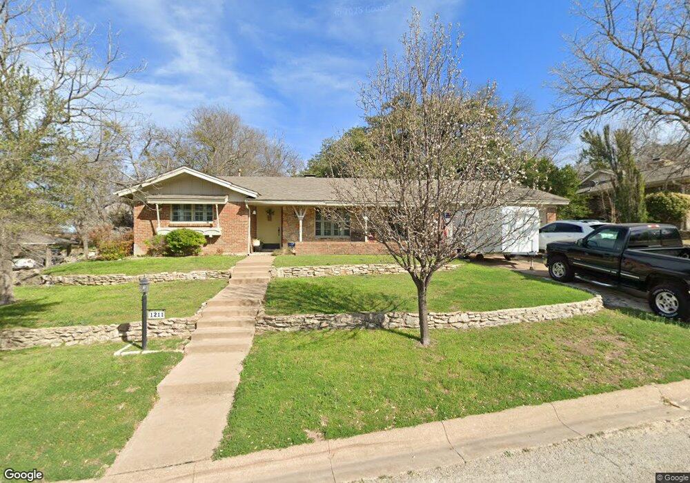
1211 S Mill St Weatherford, TX 76086
Estimated Value: $313,000 - $340,000
4
Beds
2
Baths
1,902
Sq Ft
$174/Sq Ft
Est. Value
About This Home
This home is located at 1211 S Mill St, Weatherford, TX 76086 and is currently estimated at $330,715, approximately $173 per square foot. 1211 S Mill St is a home located in Parker County with nearby schools including Austin Elementary School, Hall Middle School, and Weatherford High School.
Ownership History
Date
Name
Owned For
Owner Type
Purchase Details
Closed on
Jun 19, 2020
Sold by
Delso Terry and Delso Lee Ann
Bought by
Durant Elizabeth Ann and Durant Cloy Clayton
Current Estimated Value
Purchase Details
Closed on
Mar 18, 2011
Sold by
Shea John L and Shea Linda R
Bought by
Delso Terry and Delso Lee Ann
Home Financials for this Owner
Home Financials are based on the most recent Mortgage that was taken out on this home.
Original Mortgage
$129,896
Interest Rate
4.5%
Mortgage Type
FHA
Purchase Details
Closed on
Feb 27, 2004
Sold by
Brown Jerry A
Bought by
Delso Terry and Lee Ann
Create a Home Valuation Report for This Property
The Home Valuation Report is an in-depth analysis detailing your home's value as well as a comparison with similar homes in the area
Home Values in the Area
Average Home Value in this Area
Purchase History
| Date | Buyer | Sale Price | Title Company |
|---|---|---|---|
| Durant Elizabeth Ann | -- | None Available | |
| Delso Terry | -- | Providence Title | |
| Delso Terry | -- | -- |
Source: Public Records
Mortgage History
| Date | Status | Borrower | Loan Amount |
|---|---|---|---|
| Previous Owner | Delso Terry | $129,896 | |
| Closed | Durant Elizabeth Ann | $0 |
Source: Public Records
Tax History Compared to Growth
Tax History
| Year | Tax Paid | Tax Assessment Tax Assessment Total Assessment is a certain percentage of the fair market value that is determined by local assessors to be the total taxable value of land and additions on the property. | Land | Improvement |
|---|---|---|---|---|
| 2025 | $2,398 | $300,045 | $50,000 | $250,045 |
| 2024 | $2,398 | $300,516 | $40,000 | $260,516 |
| 2023 | $2,398 | $278,157 | $0 | $0 |
| 2022 | $5,609 | $252,870 | $20,000 | $232,870 |
| 2021 | $6,073 | $252,870 | $20,000 | $232,870 |
| 2020 | $5,105 | $211,290 | $20,000 | $191,290 |
| 2019 | $4,979 | $211,290 | $20,000 | $191,290 |
| 2018 | $4,546 | $177,240 | $20,000 | $157,240 |
| 2017 | $4,357 | $177,240 | $20,000 | $157,240 |
| 2016 | $3,961 | $150,520 | $20,000 | $130,520 |
| 2015 | $3,509 | $150,520 | $20,000 | $130,520 |
| 2014 | $3,343 | $141,450 | $20,000 | $121,450 |
Source: Public Records
Map
Nearby Homes
- S 1213 Mill St
- 1213 S Mill St
- 604 Southland Dr
- 603 Hilltop Dr
- 602 Southland Dr
- 605 Hilltop Dr
- 601 Hilltop Dr
- 606 Southland Dr
- 1212 S Mill St
- 1214 S Mill St
- 1210 S Mill St
- 1207 Bois d Arc St
- 1205 S Mill St
- 603 Southland Dr
- 1213 Bois d Arc St
- 1207 Link St
- 1302 S Mill St
- 1211 Bois d Arc St
- 608 Southland Dr
- 606 Hilltop Dr