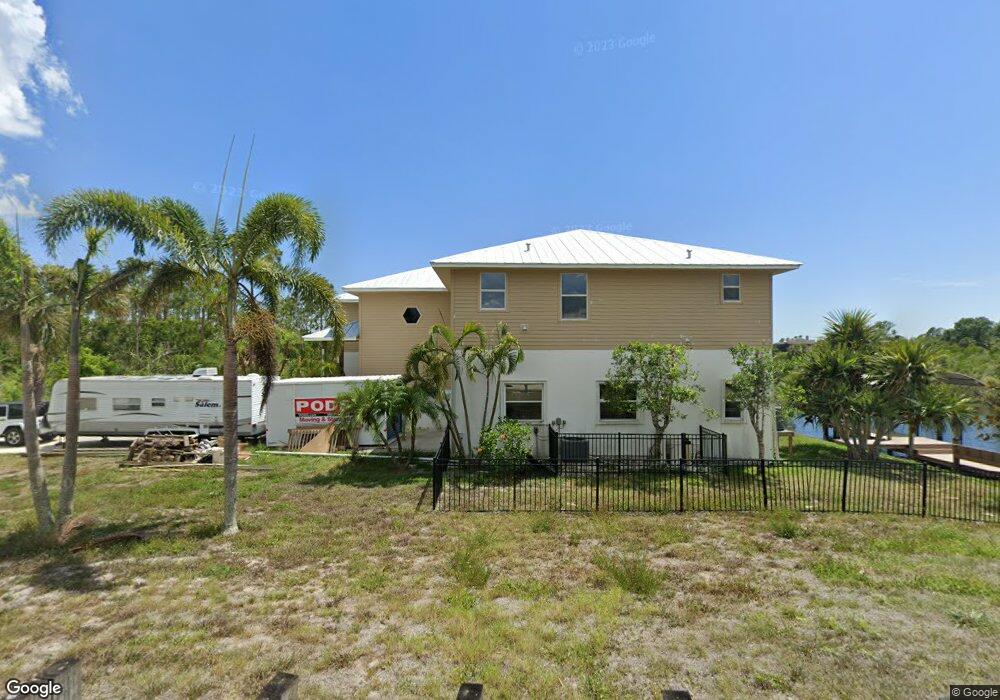
12155 Eisenhower Dr Port Charlotte, FL 33953
Northwest Port Charlotte NeighborhoodEstimated Value: $463,000 - $756,000
3
Beds
3
Baths
2,000
Sq Ft
$305/Sq Ft
Est. Value
About This Home
This home is located at 12155 Eisenhower Dr, Port Charlotte, FL 33953 and is currently estimated at $610,246, approximately $305 per square foot. 12155 Eisenhower Dr is a home located in Charlotte County with nearby schools including Liberty Elementary School, Murdock Middle School, and Port Charlotte High School.
Ownership History
Date
Name
Owned For
Owner Type
Purchase Details
Closed on
Oct 6, 2015
Sold by
Safron John E and Safron Bridget Ann
Bought by
Safron Family Revocable Trust
Current Estimated Value
Purchase Details
Closed on
Jul 21, 2005
Sold by
Bloodsworth John
Bought by
Safron John E and Safron Bridget Ann
Home Financials for this Owner
Home Financials are based on the most recent Mortgage that was taken out on this home.
Original Mortgage
$300,000
Outstanding Balance
$155,895
Interest Rate
5.59%
Mortgage Type
Fannie Mae Freddie Mac
Estimated Equity
$454,351
Purchase Details
Closed on
Nov 29, 2001
Sold by
Creegan Kevin
Bought by
Bloodsworth John
Purchase Details
Closed on
Nov 2, 1998
Sold by
Bennett Dale R and Bennett Michelle A
Bought by
Safron John E and Safron Bridget Ann
Create a Home Valuation Report for This Property
The Home Valuation Report is an in-depth analysis detailing your home's value as well as a comparison with similar homes in the area
Home Values in the Area
Average Home Value in this Area
Purchase History
| Date | Buyer | Sale Price | Title Company |
|---|---|---|---|
| Safron Family Revocable Trust | -- | Attorney | |
| Safron John E | $650,000 | -- | |
| Bloodsworth John | $17,500 | -- | |
| Safron John E | $5,500 | -- |
Source: Public Records
Mortgage History
| Date | Status | Borrower | Loan Amount |
|---|---|---|---|
| Open | Safron John E | $300,000 |
Source: Public Records
Tax History Compared to Growth
Tax History
| Year | Tax Paid | Tax Assessment Tax Assessment Total Assessment is a certain percentage of the fair market value that is determined by local assessors to be the total taxable value of land and additions on the property. | Land | Improvement |
|---|---|---|---|---|
| 2023 | $4,757 | $289,968 | $0 | $0 |
| 2022 | $4,469 | $268,319 | $0 | $0 |
| 2021 | $4,478 | $260,504 | $0 | $0 |
| 2020 | $4,422 | $256,907 | $0 | $0 |
| 2019 | $4,308 | $251,131 | $0 | $0 |
| 2018 | $4,006 | $246,448 | $0 | $0 |
| 2017 | $3,975 | $241,379 | $0 | $0 |
| 2016 | $3,961 | $236,414 | $0 | $0 |
| 2015 | $3,811 | $225,312 | $0 | $0 |
| 2014 | $3,686 | $223,524 | $0 | $0 |
Source: Public Records
Map
Nearby Homes
- 1030 Beekman Cir
- 12117 Fiske Ave
- 12060 Eisenhower Dr
- 1225 Beekman Cir
- 1217 Beekman Cir
- 1144 Anaheim St
- 1200 Anaheim St
- 1100 March Dr
- 1108 March Dr
- 1114 March Dr
- 12253 Endicott Ln
- 12266 Defender Dr
- 12373 Toynbee Ln
- 12349 Toynbee Ln
- 1188 Beekman Cir
- 12306 Defender Dr
- 12262 Toynbee Ln
- 12280 Greenleaf Ln
- 1114 Campbell St
- 12345 Greenleaf Ln
- 1004 Beekman Cir
- 12181 Eisenhower Dr
- 1014 Beekman Cir
- 12130 Eisenhower Dr
- 1022 Beekman Cir
- 1222 March Dr
- 12189 Eisenhower Dr
- 12111 Eisenhower Dr
- 1021 Beekman Cir
- 1206 March Dr
- 1038 Beekman Cir
- 12101 Eisenhower Dr
- 12085 Omaha Ave
- 12200 Eisenhower Dr
- 12119 Munn Ave
- 1173 March Dr
- 1189 March Dr
- 1095 March Dr
- 1127 & 1157 March Dr
- 1198 March Dr