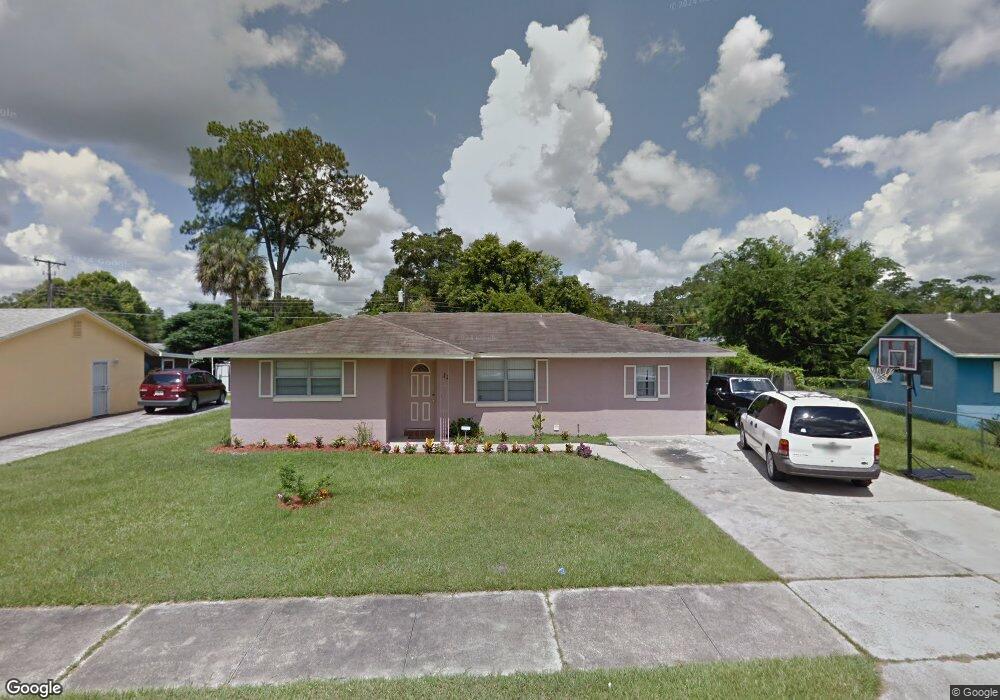
122 Scott Dr Sanford, FL 32771
Estimated Value: $229,033 - $261,000
2
Beds
3
Baths
1,472
Sq Ft
$170/Sq Ft
Est. Value
About This Home
This home is located at 122 Scott Dr, Sanford, FL 32771 and is currently estimated at $249,508, approximately $169 per square foot. 122 Scott Dr is a home located in Seminole County with nearby schools including Hamilton Elementary School, Midway Elementary School, and Pine Crest Elementary School.
Ownership History
Date
Name
Owned For
Owner Type
Purchase Details
Closed on
Jan 18, 2019
Sold by
Green Emory and Green Gladys
Bought by
Eg Enterprises Llc
Current Estimated Value
Purchase Details
Closed on
Mar 10, 2009
Sold by
Smith Estella
Bought by
Green Emury and Green Gladys
Purchase Details
Closed on
Feb 1, 1987
Bought by
Green Emory and Green Gladys
Purchase Details
Closed on
May 1, 1982
Bought by
Green Emory and Green Gladys
Purchase Details
Closed on
Jan 1, 1975
Bought by
Green Emory and Green Gladys
Purchase Details
Closed on
Jan 1, 1974
Bought by
Green Emory and Green Gladys
Create a Home Valuation Report for This Property
The Home Valuation Report is an in-depth analysis detailing your home's value as well as a comparison with similar homes in the area
Home Values in the Area
Average Home Value in this Area
Purchase History
| Date | Buyer | Sale Price | Title Company |
|---|---|---|---|
| Eg Enterprises Llc | -- | Attorney | |
| Green Emury | -- | None Available | |
| Green Emory | $36,000 | -- | |
| Green Emory | $6,100 | -- | |
| Green Emory | $100 | -- | |
| Green Emory | $100 | -- |
Source: Public Records
Tax History Compared to Growth
Tax History
| Year | Tax Paid | Tax Assessment Tax Assessment Total Assessment is a certain percentage of the fair market value that is determined by local assessors to be the total taxable value of land and additions on the property. | Land | Improvement |
|---|---|---|---|---|
| 2024 | $2,464 | $137,481 | -- | -- |
| 2023 | $2,260 | $124,983 | $0 | $0 |
| 2021 | $1,887 | $103,292 | $0 | $0 |
| 2020 | $1,724 | $93,902 | $0 | $0 |
| 2019 | $1,482 | $84,153 | $0 | $0 |
| 2018 | $1,351 | $74,770 | $0 | $0 |
| 2017 | $1,222 | $64,170 | $0 | $0 |
| 2016 | $1,182 | $60,457 | $0 | $0 |
| 2015 | $1,068 | $59,223 | $0 | $0 |
| 2014 | $1,068 | $54,857 | $0 | $0 |
Source: Public Records
Map
Nearby Homes
- 104 Hughes Ave
- 1218 Crescent St
- 884 E 20th St
- 2041 S Mellonville Ave
- 1771 Roseberry Ln
- 1315 E 24th St
- 1351 S Mellonville Ave
- 2303 Washington Ave
- 1401 Forest Dr
- Hawking Plan at Belair Place
- Beacon Plan at Belair Place
- Discovery Plan at Belair Place
- Voyager Plan at Belair Place
- Polaris Plan at Belair Place
- Endeavor Plan at Belair Place
- Equinox Plan at Belair Place
- Glimmer Plan at Belair Place
- Larissa Plan at Belair Place
- 2414 S Summerlin Ave
- 2408 Decottes Ave
- 124 Scott Dr
- 120 Scott Dr
- 1911 S Summerlin Ave
- 1909 S Summerlin Ave
- 121 Scott Dr
- 1915 S Summerlin Ave
- 1907 S Summerlin Ave
- 126 Scott Dr
- 1917 S Summerlin Ave
- 1905 S Summerlin Ave
- 125 Scott Dr
- 102 Ellen Place
- 104 Ellen Place
- 127 Scott Dr
- 119 Scott Dr
- 1919 S Summerlin Ave
- 1903 S Summerlin Ave
- 1921 S Summerlin Ave
- 132 Scott Dr
- 1901 S Summerlin Ave