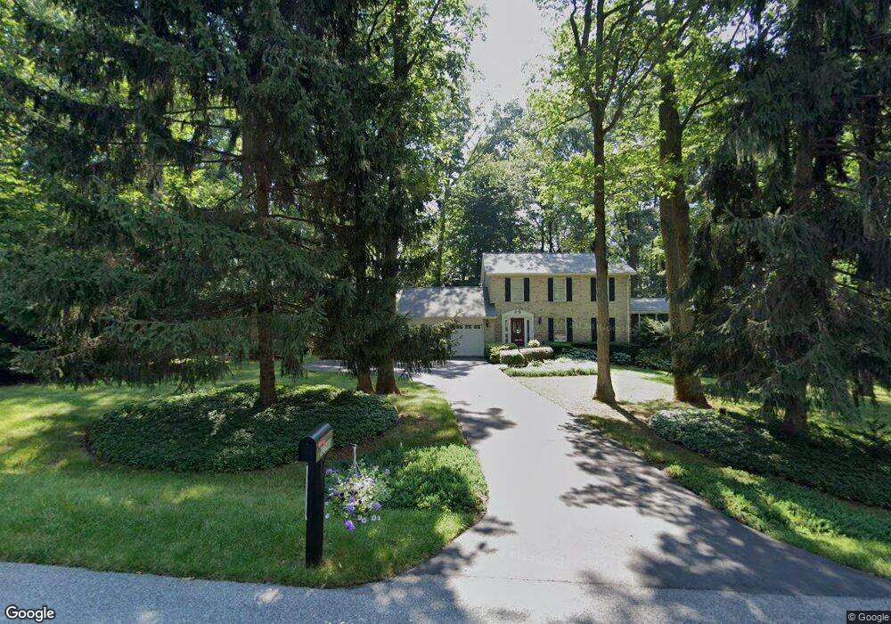
12344 Sherwood Forest Dr Mount Airy, MD 21771
Estimated Value: $573,000 - $645,000
3
Beds
3
Baths
2,592
Sq Ft
$233/Sq Ft
Est. Value
About This Home
This home is located at 12344 Sherwood Forest Dr, Mount Airy, MD 21771 and is currently estimated at $604,353, approximately $233 per square foot. 12344 Sherwood Forest Dr is a home located in Frederick County with nearby schools including New Market Elementary School, New Market Middle School, and Linganore High School.
Ownership History
Date
Name
Owned For
Owner Type
Purchase Details
Closed on
Jun 28, 2002
Sold by
Nicholson Gregory W
Bought by
Nicholson Gregory W and Nicholson Lorraine S
Current Estimated Value
Purchase Details
Closed on
Aug 4, 2000
Sold by
Shultz Michael and Shultz Joann
Bought by
Nicholson Gregory W and Nicholson Lorraine
Purchase Details
Closed on
Nov 13, 1997
Sold by
Kirschner Robert E and Kirschner Lori D
Bought by
Shultz Michael and Shultz Joann
Create a Home Valuation Report for This Property
The Home Valuation Report is an in-depth analysis detailing your home's value as well as a comparison with similar homes in the area
Home Values in the Area
Average Home Value in this Area
Purchase History
| Date | Buyer | Sale Price | Title Company |
|---|---|---|---|
| Nicholson Gregory W | -- | -- | |
| Nicholson Gregory W | $239,900 | -- | |
| Shultz Michael | $205,000 | -- |
Source: Public Records
Mortgage History
| Date | Status | Borrower | Loan Amount |
|---|---|---|---|
| Closed | Shultz Michael | -- |
Source: Public Records
Tax History Compared to Growth
Tax History
| Year | Tax Paid | Tax Assessment Tax Assessment Total Assessment is a certain percentage of the fair market value that is determined by local assessors to be the total taxable value of land and additions on the property. | Land | Improvement |
|---|---|---|---|---|
| 2025 | $5,151 | $489,033 | -- | -- |
| 2024 | $5,151 | $449,900 | $144,500 | $305,400 |
| 2023 | $4,749 | $417,833 | $0 | $0 |
| 2022 | $4,477 | $385,767 | $0 | $0 |
| 2021 | $4,108 | $353,700 | $104,500 | $249,200 |
| 2020 | $4,108 | $340,933 | $0 | $0 |
| 2019 | $3,959 | $328,167 | $0 | $0 |
| 2018 | $3,845 | $315,400 | $104,500 | $210,900 |
| 2017 | $3,739 | $315,400 | $0 | $0 |
| 2016 | $4,030 | $302,933 | $0 | $0 |
| 2015 | $4,030 | $296,700 | $0 | $0 |
| 2014 | $4,030 | $296,700 | $0 | $0 |
Source: Public Records
Map
Nearby Homes
- 12396 Lee Hill Dr
- 12775 Barnett Dr
- 4997 Tall Oaks Dr
- 5613 Bobolink Trail
- 4799 Mid Lynn Ct
- 4786 Mid County Ct
- 308 E Wainscot Dr
- 4560 Lynn Burke Rd
- 13330 Old Annapolis Rd
- 25 W Main St
- 4308 Moxley Valley Dr
- 11128 Worchester Dr
- 5633 Tessie Ct
- 4936D Green Valley Rd
- 5518 Roy Ct
- 5858 Woodville Rd
- 11907 Lime Plant Rd
- 11705 Weller Rd
- 4920 Ed Mcclain Rd
- 11397 Weller Rd
- 12346 Sherwood Forest Dr
- 12340 Sherwood Forest Dr
- 12343 Sherwood Forest Dr
- 12338 Sherwood Forest Dr
- 12345 Sherwood Forest Dr
- 12339 Sherwood Forest Dr
- 12348 Sherwood Forest Dr
- 12348A Sherwood Forest Dr
- 12336 Sherwood Forest Dr
- 12337 Sherwood Forest Dr
- 12347 Sherwood Forest Dr
- 5603 Catoctin Ridge Dr
- 12334 Sherwood Forest Dr
- 12341 Sherwood Forest Dr
- 12335 Sherwood Forest Dr
- 5605 Catoctin Ridge Dr
- 12349 Sherwood Forest Dr
- 5607 Catoctin Ridge Dr
- 5602 Catoctin Ridge Dr
- 12333 Sherwood Forest Dr