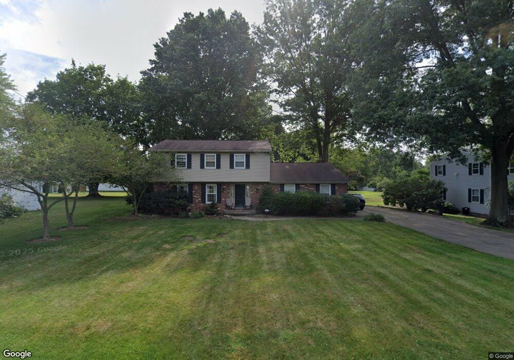
124 Brookdell Dr NW North Canton, OH 44720
Estimated Value: $288,948 - $334,000
4
Beds
3
Baths
1,972
Sq Ft
$157/Sq Ft
Est. Value
About This Home
This home is located at 124 Brookdell Dr NW, North Canton, OH 44720 and is currently estimated at $309,487, approximately $156 per square foot. 124 Brookdell Dr NW is a home located in Stark County with nearby schools including North Canton Middle School, Hoover High School, and St Paul School.
Ownership History
Date
Name
Owned For
Owner Type
Purchase Details
Closed on
Jul 6, 2005
Sold by
Housos George M and Housos Jane C
Bought by
Heather John C and Heather Danielle
Current Estimated Value
Home Financials for this Owner
Home Financials are based on the most recent Mortgage that was taken out on this home.
Original Mortgage
$144,700
Interest Rate
5.75%
Mortgage Type
Fannie Mae Freddie Mac
Create a Home Valuation Report for This Property
The Home Valuation Report is an in-depth analysis detailing your home's value as well as a comparison with similar homes in the area
Home Values in the Area
Average Home Value in this Area
Purchase History
| Date | Buyer | Sale Price | Title Company |
|---|---|---|---|
| Heather John C | $180,900 | -- |
Source: Public Records
Mortgage History
| Date | Status | Borrower | Loan Amount |
|---|---|---|---|
| Closed | Heather John C | $144,700 |
Source: Public Records
Tax History Compared to Growth
Tax History
| Year | Tax Paid | Tax Assessment Tax Assessment Total Assessment is a certain percentage of the fair market value that is determined by local assessors to be the total taxable value of land and additions on the property. | Land | Improvement |
|---|---|---|---|---|
| 2025 | -- | $90,730 | $27,480 | $63,250 |
| 2024 | -- | $90,730 | $27,480 | $63,250 |
| 2023 | $4,044 | $69,060 | $13,690 | $55,370 |
| 2022 | $3,900 | $69,060 | $13,690 | $55,370 |
| 2021 | $4,005 | $69,060 | $13,690 | $55,370 |
| 2020 | $3,830 | $60,450 | $11,800 | $48,650 |
| 2019 | $3,609 | $60,450 | $11,800 | $48,650 |
| 2018 | $3,726 | $60,450 | $11,800 | $48,650 |
| 2017 | $3,279 | $54,600 | $10,920 | $43,680 |
| 2016 | $3,140 | $52,050 | $10,920 | $41,130 |
| 2015 | $3,047 | $52,050 | $10,920 | $41,130 |
| 2014 | $945 | $48,440 | $10,150 | $38,290 |
| 2013 | $1,440 | $48,440 | $10,150 | $38,290 |
Source: Public Records
Map
Nearby Homes
- 221 Briar Ave NE
- 701 Edgewood St SE
- 634 Edgewood St SE
- 1415 Red Coach St SE
- 360 Woodside Ave NE
- 0 Marquardt Ave
- 1240 7th St NE
- 1118 Overridge Ave SE
- 714 Pershing Ave SE
- 1126 Overridge Ave SE
- 1402 Schneider St NW
- 448 Hower St NE
- 825 6th St NE
- 0 Marquardt Dr NW
- 406 Hower St NE
- 505 Rose Lane St SE
- 1321 Clinton Ave SE
- 723 Jennifer Dr NW
- 870 Honeysuckle Cir NE
- 1020 Pickforde Dr NE
- 206 Brookdell Dr NW
- 1128 E Maple St NW
- 1114 E Maple St NW
- 1140 E Maple St NW
- 219 Brookdell Dr NW
- 1148 E Maple St NW
- 1106 E Maple St NW
- 136 Brookdell Dr NW
- 1100 E Maple St NW
- 228 Brookdell Dr NW
- 1041 Dell Cir NW
- 1200 E Maple St NW
- 1048 E Maple St
- 1141 E Maple St
- 318 Brookdell Dr NW
- 1042 E Maple St
- 1149 E Maple St
- 1127 E Maple St
- 143 Brookdell Dr NW
- 1033 Dell Cir NW