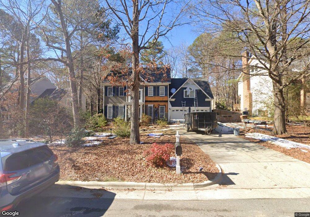
124 Southwold Dr Cary, NC 27519
West Cary NeighborhoodEstimated Value: $828,000 - $855,000
--
Bed
--
Bath
3,120
Sq Ft
$268/Sq Ft
Est. Value
About This Home
This home is located at 124 Southwold Dr, Cary, NC 27519 and is currently estimated at $837,619, approximately $268 per square foot. 124 Southwold Dr is a home located in Wake County with nearby schools including Davis Drive Elementary, Davis Drive Middle, and Green Hope High.
Ownership History
Date
Name
Owned For
Owner Type
Purchase Details
Closed on
Apr 27, 2018
Sold by
Powell Margaret and Peterson Margaret M
Bought by
Powell Margaret
Current Estimated Value
Home Financials for this Owner
Home Financials are based on the most recent Mortgage that was taken out on this home.
Original Mortgage
$318,000
Outstanding Balance
$265,385
Interest Rate
4.44%
Mortgage Type
New Conventional
Estimated Equity
$572,234
Purchase Details
Closed on
Jul 14, 1994
Bought by
Peterson Roger W and Peterson Margaret M
Create a Home Valuation Report for This Property
The Home Valuation Report is an in-depth analysis detailing your home's value as well as a comparison with similar homes in the area
Home Values in the Area
Average Home Value in this Area
Purchase History
| Date | Buyer | Sale Price | Title Company |
|---|---|---|---|
| Powell Margaret | -- | None Available | |
| Peterson Roger W | $221,500 | -- |
Source: Public Records
Mortgage History
| Date | Status | Borrower | Loan Amount |
|---|---|---|---|
| Open | Powell Margaret | $318,000 |
Source: Public Records
Tax History Compared to Growth
Tax History
| Year | Tax Paid | Tax Assessment Tax Assessment Total Assessment is a certain percentage of the fair market value that is determined by local assessors to be the total taxable value of land and additions on the property. | Land | Improvement |
|---|---|---|---|---|
| 2025 | $6,572 | $764,390 | $260,000 | $504,390 |
| 2024 | $6,429 | $764,390 | $260,000 | $504,390 |
| 2023 | $4,947 | $491,690 | $107,000 | $384,690 |
| 2022 | $4,762 | $491,690 | $107,000 | $384,690 |
| 2021 | $4,666 | $491,690 | $107,000 | $384,690 |
| 2020 | $4,691 | $491,690 | $107,000 | $384,690 |
| 2019 | $4,500 | $418,414 | $107,000 | $311,414 |
| 2018 | $4,223 | $418,414 | $107,000 | $311,414 |
| 2017 | $4,058 | $418,414 | $107,000 | $311,414 |
| 2016 | $3,997 | $418,414 | $107,000 | $311,414 |
| 2015 | $3,972 | $401,447 | $90,000 | $311,447 |
| 2014 | $3,736 | $391,762 | $90,000 | $301,762 |
Source: Public Records
Map
Nearby Homes
- 324 Farrow Glen Loop
- 410 Widdington Ln
- 100 Citrus Place
- 722 Mcrae Rd
- 210 Gingergate Dr
- 467 Methven Grove Dr
- 111 Gingergate Dr
- 209 Parkmeadow Dr
- 440 Creekhurst Place
- 437 Henmore Brook Dr
- 101 Fringe Tree Ct
- 322 Parkmeadow Dr
- 501 Riggsbee Farm Dr
- 102 Fentress Ct
- 104 Pellinore Ct
- 128 Wheatsbury Dr
- 105 Swordgate Dr
- 105 Point Harbor Dr
- 200 Carpenter Brook Dr
- 206 Highfield Ave
- 126 Southwold Dr
- 122 Southwold Dr
- 113 Lulworth Ct
- 128 Southwold Dr
- 120 Southwold Dr
- 106 Lulworth Ct
- 135 Southwold Dr
- 137 Southwold Dr
- 111 Lulworth Ct
- 133 Southwold Dr
- 130 Southwold Dr
- 118 Southwold Dr
- 139 Southwold Dr
- 131 Southwold Dr
- 132 Southwold Dr
- 129 Southwold Dr
- 104 Lulworth Ct
- 116 Southwold Dr
- 141 Southwold Dr
- 109 Lulworth Ct