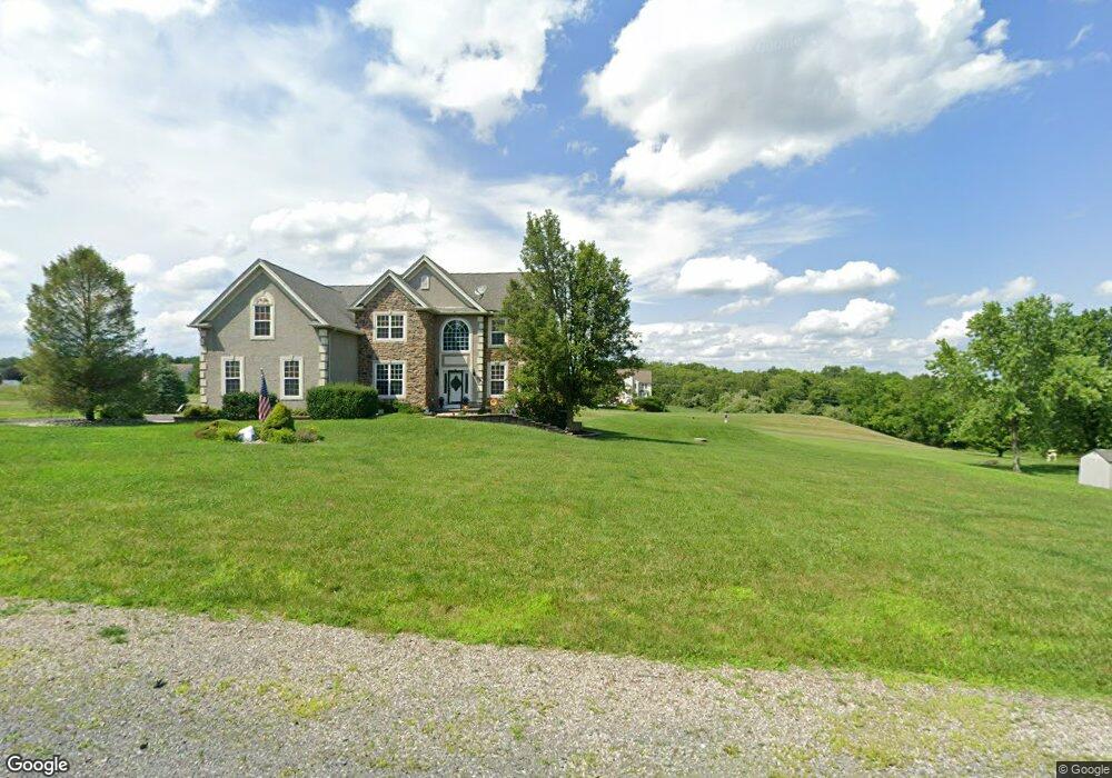
126 Birdie Way Kunkletown, PA 18058
Estimated Value: $557,213 - $736,000
4
Beds
3
Baths
3,549
Sq Ft
$182/Sq Ft
Est. Value
About This Home
This home is located at 126 Birdie Way, Kunkletown, PA 18058 and is currently estimated at $646,303, approximately $182 per square foot. 126 Birdie Way is a home located in Monroe County with nearby schools including Pleasant Valley Elementary School, Pleasant Valley Intermediate School, and Pleasant Valley Middle School.
Ownership History
Date
Name
Owned For
Owner Type
Purchase Details
Closed on
Apr 14, 2011
Sold by
Mascal Timothy R and Mascal Denise M
Bought by
Marcial Carlos J and Marcial Damaris
Current Estimated Value
Purchase Details
Closed on
May 19, 2005
Sold by
Farda Anthony
Bought by
Mascal Timothy R and Mascal Denise M
Home Financials for this Owner
Home Financials are based on the most recent Mortgage that was taken out on this home.
Original Mortgage
$285,000
Interest Rate
5.94%
Mortgage Type
New Conventional
Create a Home Valuation Report for This Property
The Home Valuation Report is an in-depth analysis detailing your home's value as well as a comparison with similar homes in the area
Home Values in the Area
Average Home Value in this Area
Purchase History
| Date | Buyer | Sale Price | Title Company |
|---|---|---|---|
| Marcial Carlos J | $320,000 | None Available | |
| Mascal Timothy R | $384,426 | Penn Jersey Abstract |
Source: Public Records
Mortgage History
| Date | Status | Borrower | Loan Amount |
|---|---|---|---|
| Previous Owner | Mascal Timothy R | $285,000 |
Source: Public Records
Tax History Compared to Growth
Tax History
| Year | Tax Paid | Tax Assessment Tax Assessment Total Assessment is a certain percentage of the fair market value that is determined by local assessors to be the total taxable value of land and additions on the property. | Land | Improvement |
|---|---|---|---|---|
| 2025 | $2,452 | $319,440 | $50,400 | $269,040 |
| 2024 | $1,973 | $319,440 | $50,400 | $269,040 |
| 2023 | $9,603 | $319,440 | $50,400 | $269,040 |
| 2022 | $9,260 | $319,440 | $50,400 | $269,040 |
| 2021 | $9,059 | $319,440 | $50,400 | $269,040 |
| 2020 | $1,654 | $319,440 | $50,400 | $269,040 |
| 2019 | $11,071 | $61,330 | $12,000 | $49,330 |
| 2018 | $10,949 | $61,330 | $12,000 | $49,330 |
| 2017 | $10,949 | $61,330 | $12,000 | $49,330 |
| 2016 | $1,886 | $61,330 | $12,000 | $49,330 |
| 2015 | -- | $61,330 | $12,000 | $49,330 |
| 2014 | -- | $61,330 | $12,000 | $49,330 |
Source: Public Records
Map
Nearby Homes
- 969 Hideaway Hill Rd
- Lot 32 Greenview Ct
- 150 Red Oak Dr
- 209 Floyd Dr
- 157 Viewtop Rd
- 1101 Red Fox Ct Unit Ct 9
- 0 T425
- CO Line Forest Dr
- 2 T425
- 207 Scenic Dr
- 90 Halina Way
- 0 Sr 209 Unit PM-130225
- 85 Panorama Cir
- 125 Hillview Rd
- 1182 Quail Rd
- 229 Deer Path
- 0 Victoria Arms Cir Unit PM-133039
- 2650 57 Rd
- 142 Pine Grove Rd
- 160 Grassy Rd