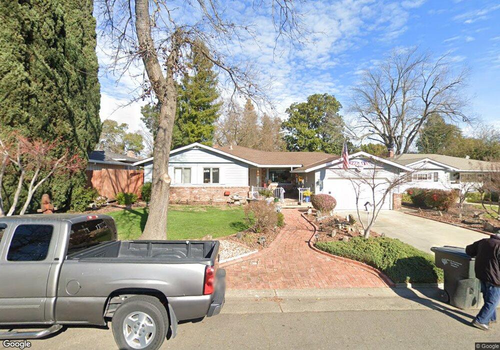
1261 Lucio Ln Sacramento, CA 95822
South Land Park NeighborhoodEstimated Value: $511,000 - $800,000
3
Beds
3
Baths
1,978
Sq Ft
$354/Sq Ft
Est. Value
About This Home
This home is located at 1261 Lucio Ln, Sacramento, CA 95822 and is currently estimated at $700,745, approximately $354 per square foot. 1261 Lucio Ln is a home located in Sacramento County with nearby schools including Sutterville Elementary School, California Middle, and C. K. McClatchy High.
Ownership History
Date
Name
Owned For
Owner Type
Purchase Details
Closed on
May 11, 2021
Sold by
Gibson James E and The Gibson Family Trust
Bought by
Gibson James E and The Laurel D Gibson Family Tru
Current Estimated Value
Purchase Details
Closed on
Apr 1, 2009
Sold by
Densmore Gibson James Edward and Densmore Gibson Laurel
Bought by
Gibson James E and Gibson Laurel D
Purchase Details
Closed on
Mar 25, 1999
Sold by
Gibson James Edward
Bought by
Densmore Gibson James Edward and Densmore Gibson Laurel
Create a Home Valuation Report for This Property
The Home Valuation Report is an in-depth analysis detailing your home's value as well as a comparison with similar homes in the area
Home Values in the Area
Average Home Value in this Area
Purchase History
| Date | Buyer | Sale Price | Title Company |
|---|---|---|---|
| Gibson James E | -- | None Available | |
| Gibson James E | -- | None Available | |
| Gibson James E | -- | None Available | |
| Densmore Gibson James Edward | -- | -- |
Source: Public Records
Tax History Compared to Growth
Tax History
| Year | Tax Paid | Tax Assessment Tax Assessment Total Assessment is a certain percentage of the fair market value that is determined by local assessors to be the total taxable value of land and additions on the property. | Land | Improvement |
|---|---|---|---|---|
| 2025 | $3,115 | $257,901 | $78,072 | $179,829 |
| 2024 | $3,115 | $252,845 | $76,542 | $176,303 |
| 2023 | $3,033 | $247,889 | $75,042 | $172,847 |
| 2022 | $2,994 | $243,029 | $73,571 | $169,458 |
| 2021 | $2,847 | $238,265 | $72,129 | $166,136 |
| 2020 | $2,863 | $235,823 | $71,390 | $164,433 |
| 2019 | $2,801 | $231,200 | $69,991 | $161,209 |
| 2018 | $2,727 | $226,668 | $68,619 | $158,049 |
| 2017 | $2,683 | $222,224 | $67,274 | $154,950 |
| 2016 | $2,557 | $217,867 | $65,955 | $151,912 |
| 2015 | $2,512 | $214,596 | $64,965 | $149,631 |
| 2014 | $2,450 | $210,393 | $63,693 | $146,700 |
Source: Public Records
Map
Nearby Homes
- 5440 Pleasant Dr
- 1220 Lucio Ln
- 1224 Nevis Ct
- 5200 Pleasant Dr
- 1432 Oregon Dr
- 1428 Tradewinds Ave
- 5779 Gloria Dr
- 1433 32nd Ave
- 1122 28th Ave
- 5880 Gloria Dr
- 5875 Gloria Dr Unit 4
- 1621 Fruitridge Rd
- 1436 Sterling St
- 4801 da Rosa Dr
- 5716 Lonsdale Dr
- 5081 Karbet Way
- 4500 Crestwood Way
- 1548 London St
- 5531 Michael Way
- 1810 Opper Ave