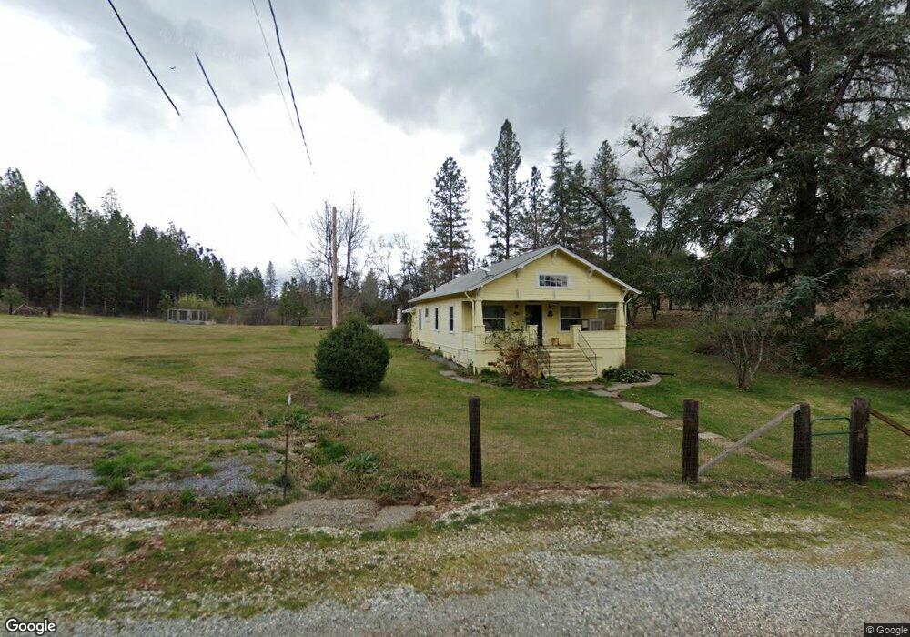
12695 Cement Hill Rd Nevada City, CA 95959
Estimated Value: $549,000 - $644,000
2
Beds
2
Baths
1,848
Sq Ft
$323/Sq Ft
Est. Value
About This Home
This home is located at 12695 Cement Hill Rd, Nevada City, CA 95959 and is currently estimated at $596,500, approximately $322 per square foot. 12695 Cement Hill Rd is a home located in Nevada County with nearby schools including Deer Creek Elementary School, Seven Hills Intermediate School, and Forest Charter School.
Ownership History
Date
Name
Owned For
Owner Type
Purchase Details
Closed on
Oct 19, 2004
Sold by
Orzalli Dale A
Bought by
Orzalli Dale A and Orzalli Phyllis R
Current Estimated Value
Purchase Details
Closed on
Sep 10, 2004
Sold by
Orzalli Roger L
Bought by
Orzalli Roger L
Purchase Details
Closed on
May 4, 2004
Sold by
Orzalli Dale A and Orzalli Roger L
Bought by
Orzalli Dale A and Orzalli Roger L
Purchase Details
Closed on
Aug 19, 1997
Sold by
Orzalli Evelyn M
Bought by
Orzalli Dale A and Orzalli Roger L
Create a Home Valuation Report for This Property
The Home Valuation Report is an in-depth analysis detailing your home's value as well as a comparison with similar homes in the area
Home Values in the Area
Average Home Value in this Area
Purchase History
| Date | Buyer | Sale Price | Title Company |
|---|---|---|---|
| Orzalli Dale A | -- | -- | |
| Orzalli Roger L | -- | -- | |
| Orzalli Dale A | -- | -- | |
| Orzalli Dale A | -- | -- | |
| Orzalli Evelyn M | -- | -- |
Source: Public Records
Tax History Compared to Growth
Tax History
| Year | Tax Paid | Tax Assessment Tax Assessment Total Assessment is a certain percentage of the fair market value that is determined by local assessors to be the total taxable value of land and additions on the property. | Land | Improvement |
|---|---|---|---|---|
| 2025 | $3,190 | $270,288 | $73,521 | $196,767 |
| 2024 | $3,122 | $264,989 | $72,080 | $192,909 |
| 2023 | $3,122 | $259,794 | $70,667 | $189,127 |
| 2022 | $3,057 | $254,701 | $69,282 | $185,419 |
| 2021 | $2,960 | $249,708 | $67,924 | $181,784 |
| 2020 | $2,948 | $247,149 | $67,228 | $179,921 |
| 2019 | $2,887 | $242,304 | $65,910 | $176,394 |
| 2018 | $0 | $237,554 | $64,618 | $172,936 |
| 2017 | $2,774 | $232,897 | $63,351 | $169,546 |
| 2016 | $2,677 | $228,331 | $62,109 | $166,222 |
| 2015 | $2,637 | $224,903 | $61,177 | $163,726 |
| 2014 | $2,637 | $220,498 | $59,979 | $160,519 |
Source: Public Records
Map
Nearby Homes
- 13118 Cement Hill Rd
- 13000 Diamond Oaks Dr
- 12777 Daisy Blue Mine Rd
- 16934 Indian Flat Rd
- 10402 Newtown Rd
- 11094 Cement Hill Rd
- 10265 Newtown Rd
- 10980 Newtown Rd
- 11065 White Oak Way
- 11356 Constitution Ct
- 10943 Beckville Rd
- 12069 Newtown Rd
- 12141 Newtown Rd
- 16970 Old Downieville Hwy
- 17271 Lake Vera Purdon Rd
- 708 W Broad St
- 661 Chief Kelly Dr
- 651 Chief Kelly Dr
- 660 Chief Kelly Dr
- 140 Redbud Way
- 14578 Sunrock Rd
- 12785 Cement Hill Rd
- 12491 Cement Hill Rd
- 14700 Sunrock Rd
- 12650 Cement Hill Rd
- 12762 Cement Hill Rd
- 12498 Cement Hill Rd
- 12430 Cement Hill Rd
- 10827 John Barleycorn Rd
- 14624 Sunrock Rd
- 12550 Cement Hill Rd
- 14668 Applewood Ln
- 14327 Sunrock Rd
- 14655 Applewood Ln
- 14722 Applewood Ln
- 10539 Crooked Arrow Ln
- 10904 John Barleycorn Rd
- 14450 Sunrock Rd