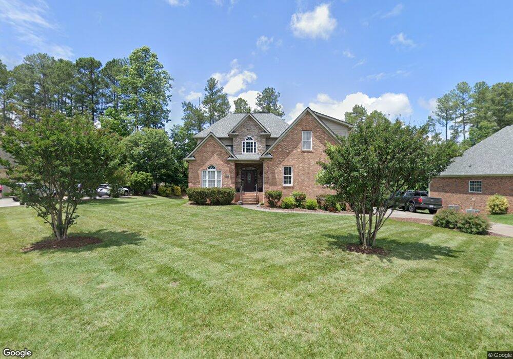
1278 Meadowlands Dr Winston Salem, NC 27107
Estimated Value: $588,000 - $607,000
3
Beds
4
Baths
5,780
Sq Ft
$103/Sq Ft
Est. Value
About This Home
This home is located at 1278 Meadowlands Dr, Winston Salem, NC 27107 and is currently estimated at $595,293, approximately $102 per square foot. 1278 Meadowlands Dr is a home located in Davidson County with nearby schools including Wallburg Elementary School, Oak Grove Middle School, and Oak Grove High School.
Ownership History
Date
Name
Owned For
Owner Type
Purchase Details
Closed on
Aug 3, 2007
Sold by
Setty Enterprises Inc
Bought by
Gibson Diounte and Gibson Tiffany
Current Estimated Value
Home Financials for this Owner
Home Financials are based on the most recent Mortgage that was taken out on this home.
Original Mortgage
$317,300
Outstanding Balance
$199,869
Interest Rate
6.56%
Mortgage Type
Purchase Money Mortgage
Estimated Equity
$395,424
Purchase Details
Closed on
Aug 7, 2006
Sold by
Meadowlands Development Llc
Bought by
Setty Enterprises Inc
Create a Home Valuation Report for This Property
The Home Valuation Report is an in-depth analysis detailing your home's value as well as a comparison with similar homes in the area
Home Values in the Area
Average Home Value in this Area
Purchase History
| Date | Buyer | Sale Price | Title Company |
|---|---|---|---|
| Gibson Diounte | $334,000 | None Available | |
| Setty Enterprises Inc | $165,000 | None Available |
Source: Public Records
Mortgage History
| Date | Status | Borrower | Loan Amount |
|---|---|---|---|
| Open | Gibson Diounte | $317,300 |
Source: Public Records
Tax History Compared to Growth
Tax History
| Year | Tax Paid | Tax Assessment Tax Assessment Total Assessment is a certain percentage of the fair market value that is determined by local assessors to be the total taxable value of land and additions on the property. | Land | Improvement |
|---|---|---|---|---|
| 2025 | $2,493 | $383,550 | $0 | $0 |
| 2024 | $2,418 | $383,550 | $0 | $0 |
| 2023 | $2,418 | $383,550 | $0 | $0 |
| 2022 | $2,418 | $383,550 | $0 | $0 |
| 2021 | $2,418 | $383,550 | $0 | $0 |
| 2020 | $2,216 | $351,600 | $0 | $0 |
| 2019 | $2,250 | $351,600 | $0 | $0 |
| 2018 | $2,250 | $351,600 | $0 | $0 |
| 2017 | $2,250 | $351,600 | $0 | $0 |
| 2016 | $2,250 | $351,600 | $0 | $0 |
| 2015 | $2,250 | $351,600 | $0 | $0 |
| 2014 | $2,134 | $333,450 | $0 | $0 |
Source: Public Records
Map
Nearby Homes
- 380 Olde Lantern Dr
- 386 Olde Lantern Dr
- 387 Olde Lantern Dr
- 312 Olde Lantern Dr
- 134 New Forest Dr
- 298 Olde Lantern Dr
- 309 Olde Lantern Dr
- 150 New Forest Dr
- 168 New Forest Dr
- 270 Olde Lantern Dr
- 184 New Forest Dr
- 213 Red Hawk Ln
- 153 Turtle Bay Ct
- 138 Green Forest Ct
- 170 Green Forest Ct
- 186 Green Forest Ct
- 282 Heatherwood Dr
- 221 Green Forest Ct
- 202 Green Forest Ct
- 226 Green Forest Ct
- 1254 Meadowlands Dr
- 1304 Meadowlands Dr
- 207 Kiawah Island Dr
- 193 Kiawah Island Dr
- 110 Southern Woods Dr
- 1330 Meadowlands Dr
- 109 Southern Woods Dr
- 237 Kiawah Island Dr
- 177 Kiawah Island Dr
- 1210 Meadowlands Dr
- 1311 Meadowlands Dr
- 125 Southern Woods Dr
- 128 Southern Woods Dr
- 1227 Meadowlands Dr
- 253 Kiawah Island Dr
- 1356 Meadowlands Dr
- 1325 Meadowlands Dr
- 163 Kiawah Island Dr
- 242 Kiawah Island Dr
- 143 Southern Woods Dr