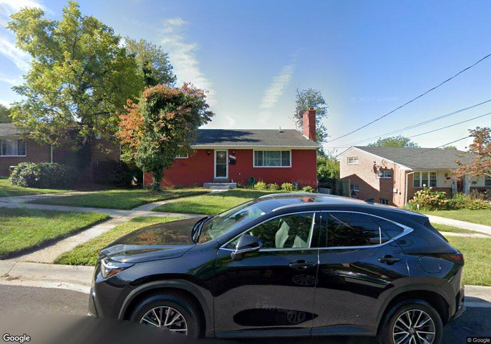
12816 Crisfield Rd Silver Spring, MD 20906
Connecticut Avenue Park NeighborhoodEstimated Value: $526,714 - $554,000
--
Bed
3
Baths
1,680
Sq Ft
$325/Sq Ft
Est. Value
About This Home
This home is located at 12816 Crisfield Rd, Silver Spring, MD 20906 and is currently estimated at $545,679, approximately $324 per square foot. 12816 Crisfield Rd is a home located in Montgomery County with nearby schools including Walters Elementary School, Weller Road Elementary School, and A. Mario Loiederman Middle School.
Ownership History
Date
Name
Owned For
Owner Type
Purchase Details
Closed on
Jan 4, 2002
Sold by
Ma Ming Gang
Bought by
Melake Melete
Current Estimated Value
Purchase Details
Closed on
Oct 6, 1994
Sold by
Mergner Robert B
Bought by
Ma Ming Gang
Home Financials for this Owner
Home Financials are based on the most recent Mortgage that was taken out on this home.
Original Mortgage
$143,450
Interest Rate
8.55%
Create a Home Valuation Report for This Property
The Home Valuation Report is an in-depth analysis detailing your home's value as well as a comparison with similar homes in the area
Home Values in the Area
Average Home Value in this Area
Purchase History
| Date | Buyer | Sale Price | Title Company |
|---|---|---|---|
| Melake Melete | $215,000 | -- | |
| Ma Ming Gang | $151,000 | -- |
Source: Public Records
Mortgage History
| Date | Status | Borrower | Loan Amount |
|---|---|---|---|
| Previous Owner | Ma Ming Gang | $143,450 |
Source: Public Records
Tax History Compared to Growth
Tax History
| Year | Tax Paid | Tax Assessment Tax Assessment Total Assessment is a certain percentage of the fair market value that is determined by local assessors to be the total taxable value of land and additions on the property. | Land | Improvement |
|---|---|---|---|---|
| 2025 | $5,502 | $447,100 | $194,800 | $252,300 |
| 2024 | $5,502 | $414,433 | $0 | $0 |
| 2023 | $4,410 | $381,767 | $0 | $0 |
| 2022 | $3,814 | $349,100 | $172,800 | $176,300 |
| 2021 | $3,587 | $343,400 | $0 | $0 |
| 2020 | $3,587 | $337,700 | $0 | $0 |
| 2019 | $3,490 | $332,000 | $157,800 | $174,200 |
| 2018 | $3,420 | $327,900 | $0 | $0 |
| 2017 | $3,428 | $323,800 | $0 | $0 |
| 2016 | -- | $319,700 | $0 | $0 |
| 2015 | $2,669 | $303,933 | $0 | $0 |
| 2014 | $2,669 | $288,167 | $0 | $0 |
Source: Public Records
Map
Nearby Homes
- 3409 Janet Rd
- 3503 Kayson St
- 13005 Bluhill Rd
- 12929 Valleywood Dr
- 13009 Valleywood Dr
- 13116 Estelle Rd
- 12904 Flack St
- 13202 Holdridge Rd
- 13206 May Ct
- 13208 Holdridge Rd
- 3122 Helsel Dr
- 12704 Bushey Dr
- 12814 Epping Terrace
- 12835 Littleton St
- 3945 Wendy Ln
- 13316 Foxhall Dr
- 3312 Clay St
- 13216 Turkey Branch Pkwy
- 12220 Centerhill St
- 3240 Hewitt Ave Unit 43
- 12818 Crisfield Rd
- 12814 Crisfield Rd
- 12815 Dean Rd
- 3514 Kayson St
- 12820 Crisfield Rd
- 12813 Dean Rd
- 12817 Dean Rd
- 12810 Crisfield Rd
- 12819 Crisfield Rd
- 12817 Crisfield Rd
- 12821 Crisfield Rd
- 12815 Crisfield Rd
- 12823 Crisfield Rd
- 12813 Crisfield Rd
- 12809 Dean Rd
- 12825 Crisfield Rd
- 12808 Crisfield Rd
- 12811 Crisfield Rd
- 12807 Dean Rd
- 3517 Kayson St