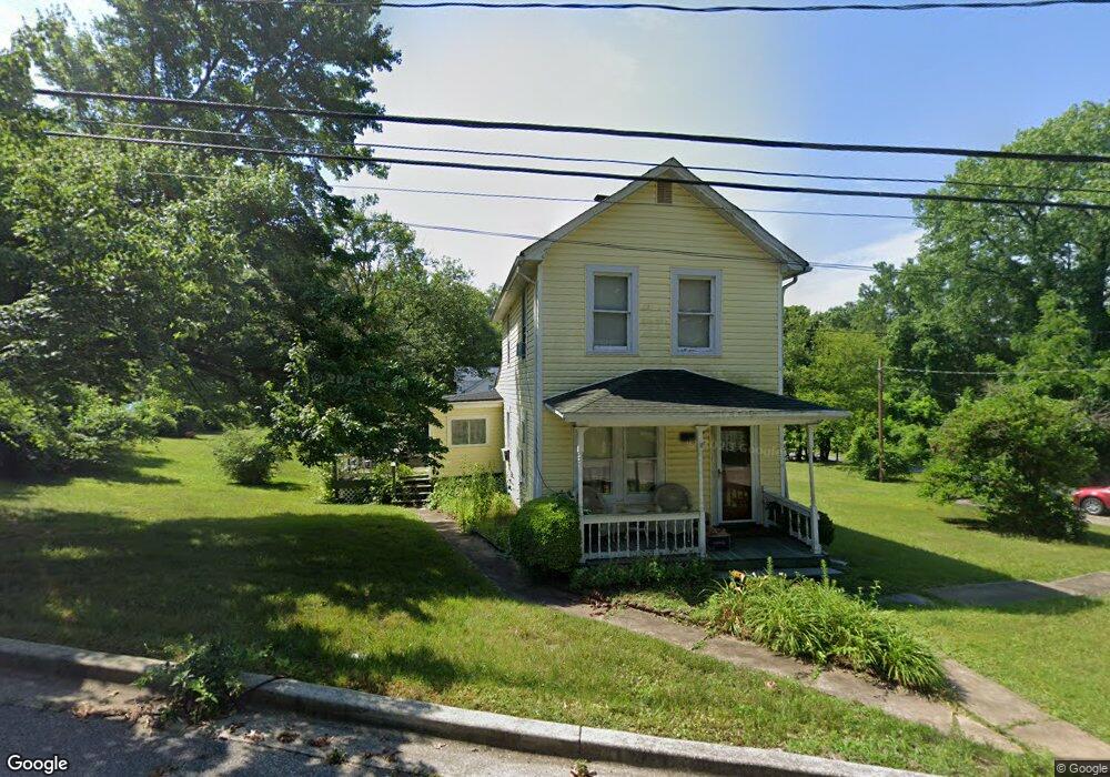
12819 10th St Bowie, MD 20720
Old Bowie NeighborhoodEstimated Value: $338,811 - $413,000
--
Bed
1
Bath
1,496
Sq Ft
$258/Sq Ft
Est. Value
About This Home
This home is located at 12819 10th St, Bowie, MD 20720 and is currently estimated at $385,703, approximately $257 per square foot. 12819 10th St is a home located in Prince George's County with nearby schools including Rockledge Elementary School, Samuel Ogle Middle School, and Bowie High School.
Ownership History
Date
Name
Owned For
Owner Type
Purchase Details
Closed on
Apr 11, 2003
Sold by
Lloyd John E
Bought by
Lloyd Amy E
Current Estimated Value
Purchase Details
Closed on
Feb 21, 1995
Sold by
Marek Michael F
Bought by
Lloyd John E
Home Financials for this Owner
Home Financials are based on the most recent Mortgage that was taken out on this home.
Original Mortgage
$81,800
Interest Rate
9.19%
Purchase Details
Closed on
Apr 6, 1982
Sold by
Shegogue Mary J K
Bought by
Marek Michael F and Marek Dorothy T
Create a Home Valuation Report for This Property
The Home Valuation Report is an in-depth analysis detailing your home's value as well as a comparison with similar homes in the area
Home Values in the Area
Average Home Value in this Area
Purchase History
| Date | Buyer | Sale Price | Title Company |
|---|---|---|---|
| Lloyd Amy E | -- | -- | |
| Lloyd John E | $82,000 | -- | |
| Marek Michael F | $50,000 | -- |
Source: Public Records
Mortgage History
| Date | Status | Borrower | Loan Amount |
|---|---|---|---|
| Previous Owner | Lloyd John E | $81,800 |
Source: Public Records
Tax History Compared to Growth
Tax History
| Year | Tax Paid | Tax Assessment Tax Assessment Total Assessment is a certain percentage of the fair market value that is determined by local assessors to be the total taxable value of land and additions on the property. | Land | Improvement |
|---|---|---|---|---|
| 2025 | $4,242 | $256,000 | $103,200 | $152,800 |
| 2024 | $4,242 | $247,133 | $0 | $0 |
| 2023 | $3,255 | $238,267 | $0 | $0 |
| 2022 | $3,902 | $229,400 | $103,200 | $126,200 |
| 2021 | $3,749 | $221,100 | $0 | $0 |
| 2020 | $3,601 | $212,800 | $0 | $0 |
| 2019 | $3,470 | $204,500 | $101,600 | $102,900 |
| 2018 | $3,255 | $191,233 | $0 | $0 |
| 2017 | $3,046 | $177,967 | $0 | $0 |
| 2016 | -- | $164,700 | $0 | $0 |
| 2015 | $2,488 | $164,700 | $0 | $0 |
| 2014 | $2,488 | $164,700 | $0 | $0 |
Source: Public Records
Map
Nearby Homes
- 12808 10th St
- 12800 7th St
- 12707 Duckettown Rd
- The Jenkins Plan at Mill Branch Crossing - Townhomes
- 12603 Lanham Severn Rd
- 8823 Maple Ave
- 8824 Old Laurel Bowie Rd
- 13123 10th St
- 13001 4th St
- 13118 6th St
- 13205 10th St
- 8405 Spruill Dr
- 0 5th St Unit MDPG2135750
- 8424 Spruill Dr
- 9112 Myrtle Ave
- 13314 10th St
- 13322 11th St
- 8608 Pine Ave
- 8244 Quill Point Dr
- 8106 Triple Crown Rd