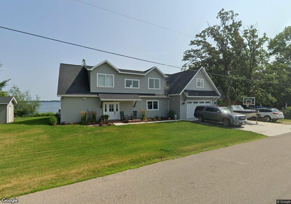
12867 W Lake Sallie Dr Detroit Lakes, MN 56501
Estimated Value: $1,087,000 - $1,263,000
4
Beds
2
Baths
3,380
Sq Ft
$338/Sq Ft
Est. Value
About This Home
This home is located at 12867 W Lake Sallie Dr, Detroit Lakes, MN 56501 and is currently estimated at $1,143,277, approximately $338 per square foot. 12867 W Lake Sallie Dr is a home located in Becker County with nearby schools including Detroit Lakes Senior High School and Faith Christian School.
Ownership History
Date
Name
Owned For
Owner Type
Purchase Details
Closed on
Dec 2, 2022
Sold by
Hedlund Robert H
Bought by
Ingvalson Kathleen and Ingvalson Derek
Current Estimated Value
Purchase Details
Closed on
Jul 9, 2020
Sold by
Anstett Paul A and Anstett Marilyn S
Bought by
Ingvalson Kathleen and Ingvalson Kathleen
Purchase Details
Closed on
Aug 27, 2004
Sold by
Kunkle E W and Kunkle Genevieve G
Bought by
Anstett Paul A and Anstett Marilyn S
Create a Home Valuation Report for This Property
The Home Valuation Report is an in-depth analysis detailing your home's value as well as a comparison with similar homes in the area
Home Values in the Area
Average Home Value in this Area
Purchase History
| Date | Buyer | Sale Price | Title Company |
|---|---|---|---|
| Ingvalson Kathleen | -- | -- | |
| Ingvalson Kathleen | $350,000 | None Available | |
| Anstett Paul A | $32,000 | None Available |
Source: Public Records
Tax History Compared to Growth
Tax History
| Year | Tax Paid | Tax Assessment Tax Assessment Total Assessment is a certain percentage of the fair market value that is determined by local assessors to be the total taxable value of land and additions on the property. | Land | Improvement |
|---|---|---|---|---|
| 2025 | $7,336 | $1,074,900 | $518,200 | $556,700 |
| 2024 | $7,820 | $1,103,300 | $508,800 | $594,500 |
| 2023 | $5,666 | $755,200 | $409,900 | $345,300 |
| 2022 | $4,532 | $557,200 | $352,800 | $204,400 |
| 2021 | $5,738 | $638,400 | $360,900 | $277,500 |
| 2020 | $5,912 | $638,400 | $360,900 | $277,500 |
| 2019 | $5,318 | $641,600 | $360,900 | $280,700 |
| 2018 | $4,230 | $568,800 | $327,300 | $241,500 |
| 2017 | $3,576 | $527,100 | $289,800 | $237,300 |
| 2016 | $3,838 | $437,800 | $234,400 | $203,400 |
| 2015 | $3,670 | $450,500 | $234,400 | $216,100 |
| 2014 | -- | $391,100 | $183,600 | $207,500 |
Source: Public Records
Map
Nearby Homes
- 14196 E Fox Lake Rd
- 14473 Barnes Dr
- 12104 County Highway 17
- 23519 W Foxview Ln
- 23545 W Foxview Ln
- 23093 Roosevelt Beach Ln
- 23271 Roosevelt Beach Ln
- TBD N Fox Lake Ln
- 11494 Ravenswood Beach Rd
- 24594 S Melissa Dr
- 13847 Pearl Lake Ln
- 12xxx County Highway 17
- 15216 E Munson Dr
- 21335 Halstad Lake Rd
- TBD 130th St
- 15356 Sunset Hill Dr
- 1 Branch Creek Rd
- 24 Branch Creek Rd
- Lots 5 & 6 Branch Creek Rd
- 21 Branch Creek Rd
- 12853 W Lake Sallie Dr
- 12847 W Lake Sallie Dr
- 12825 W Lake Sallie Dr
- 12809 W Lake Sallie Dr
- 12803 W Lake Sallie Dr
- 12808 W Lake Sallie Dr
- 12793 W Lake Sallie Dr
- 12761 W Lake Sallie Dr
- 12728 W Common Rd
- 12973 W Lake Sallie Dr
- 12753 W Lake Sallie Dr
- 12985 W Lake Sallie Dr
- 12745 W Lake Sallie Dr
- 12735 E Common Rd
- 12735 W Lake Sallie Dr
- 12991 W Lake Sallie Dr
- 12696 W Common Rd
- 12997 W Lake Sallie Dr
- 12725 W Lake Sallie Dr
- 12713 W Lake Sallie Dr