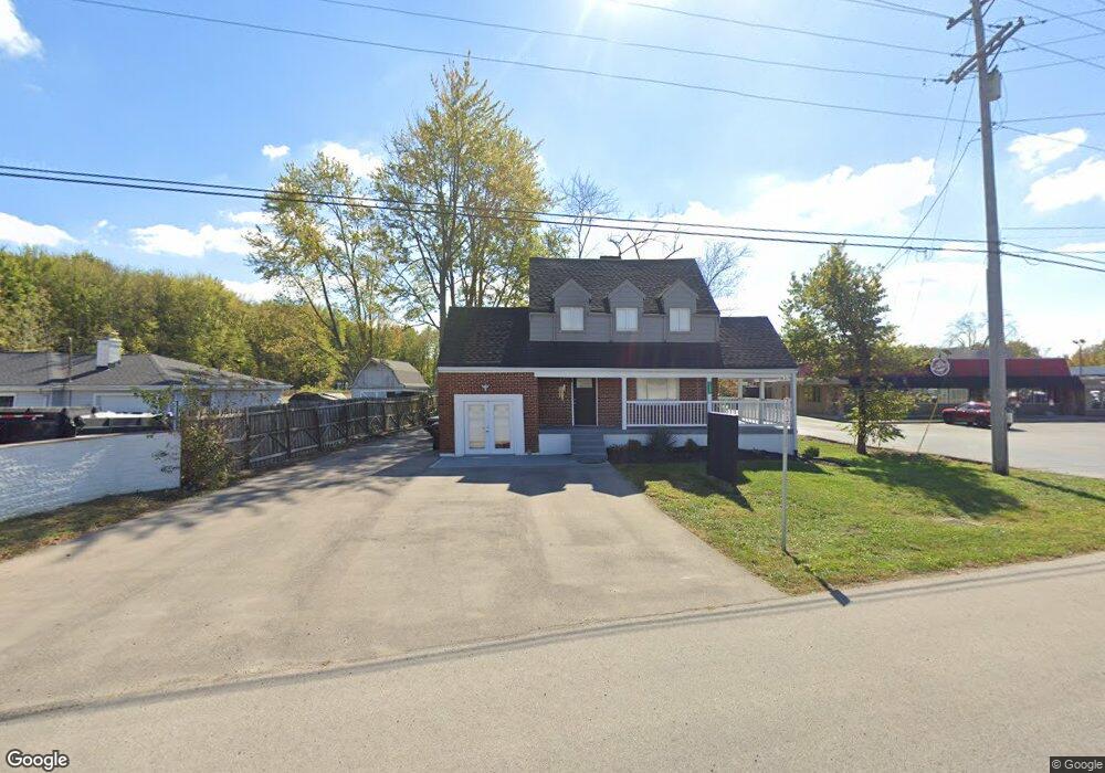
1289 State Route 28 Loveland, OH 45140
Estimated Value: $128,000 - $216,000
3
Beds
1
Bath
828
Sq Ft
$214/Sq Ft
Est. Value
About This Home
This home is located at 1289 State Route 28, Loveland, OH 45140 and is currently estimated at $176,931, approximately $213 per square foot. 1289 State Route 28 is a home located in Clermont County with nearby schools including Milford Senior High School, Milford Christian Academy, and St. Andrew - St. Elizabeth Ann Seton School.
Ownership History
Date
Name
Owned For
Owner Type
Purchase Details
Closed on
Oct 21, 2024
Sold by
Br Holdings Unlimited Llc
Bought by
1289 Ohio 28 Llc
Current Estimated Value
Purchase Details
Closed on
Dec 2, 2021
Sold by
Paracelsus Llc
Bought by
Br Holdngs Unlimtted Llc
Purchase Details
Closed on
Oct 25, 2019
Sold by
Townley James E and Townley Geraldine
Bought by
Paracelsus Llc
Purchase Details
Closed on
Nov 14, 2013
Sold by
Townley Jeffrey
Bought by
Townley James E and Townley Geraldine
Purchase Details
Closed on
Feb 4, 2011
Sold by
Townley Jack Grant
Bought by
Townley Jack G and The Jack G Townley Trust
Purchase Details
Closed on
Aug 31, 2005
Sold by
Estate Of Shirley Mae Townley
Bought by
Townley Jack Grant and Townley Jack C
Create a Home Valuation Report for This Property
The Home Valuation Report is an in-depth analysis detailing your home's value as well as a comparison with similar homes in the area
Home Values in the Area
Average Home Value in this Area
Purchase History
| Date | Buyer | Sale Price | Title Company |
|---|---|---|---|
| 1289 Ohio 28 Llc | -- | None Listed On Document | |
| Br Holdngs Unlimtted Llc | $107,500 | American Homeland Title | |
| Paracelsus Llc | $75,000 | American Homeland Title | |
| Townley James E | -- | None Available | |
| Townley Jack G | -- | Attorney | |
| Townley Jack Grant | -- | -- |
Source: Public Records
Tax History Compared to Growth
Tax History
| Year | Tax Paid | Tax Assessment Tax Assessment Total Assessment is a certain percentage of the fair market value that is determined by local assessors to be the total taxable value of land and additions on the property. | Land | Improvement |
|---|---|---|---|---|
| 2024 | $2,378 | $26,430 | $14,110 | $12,320 |
| 2023 | $2,403 | $26,430 | $14,110 | $12,320 |
| 2022 | $1,628 | $26,260 | $10,680 | $15,580 |
| 2021 | $1,629 | $26,260 | $10,680 | $15,580 |
| 2020 | $4,721 | $26,430 | $10,680 | $15,750 |
| 2019 | $2,870 | $26,430 | $10,680 | $15,750 |
| 2018 | $2,888 | $26,430 | $10,680 | $15,750 |
| 2017 | $2,483 | $26,430 | $10,680 | $15,750 |
| 2016 | $2,957 | $26,430 | $10,680 | $15,750 |
| 2015 | $2,459 | $26,430 | $10,680 | $15,750 |
| 2014 | $2,405 | $26,430 | $10,680 | $15,750 |
| 2013 | $1,757 | $26,430 | $10,080 | $16,350 |
Source: Public Records
Map
Nearby Homes
- 1285 State Rte 28
- 1289 Woodville Pike
- 6077 Branch Hill Guinea Pike
- 6320 Ashford Dr
- 6108 Donna Jay Dr
- 5975 Buckwheat Rd
- 6074 Deerfield Rd Unit 28
- 6074 Deerfield Rd Unit 317
- 6074 Deerfield Rd Unit 314
- 6074 Deerfield Rd Unit 507
- 6074 Deerfield Rd Unit 304
- 6074 Deerfield Rd Unit 78
- 6074 Deerfield Rd Unit 205
- 6074 Deerfield Rd Unit 97
- 6074 Deerfield Rd Unit 310
- 6074 Deerfield Rd Unit 203
- 6074 Deerfield Rd Unit 8
- 6074 Deerfield Rd Unit 306
- 6211 Spires Dr
- 5942 Pinto Place
- 1293 St Rt 28
- 1293 State Route 28
- 1289 St Rt 28
- 1289 St Rt 28
- 1297 Main St
- 1280 Ohio 28
- 1290 Woodville Pike
- 1305 Ohio 28
- 1276 Woodville Pike
- 1278 Woodville Pike
- 1282 Woodville Pike
- 1294 Woodville Pike
- 1302 Woodville Pike
- 1306 Woodville Pike
- 1285 Woodville Pike
- 1281 Woodville Pike
- 1277 Woodville Pike
- 6055 Branch Hill-Guinea Pike
- 1273 Woodville Pike
- 6022 Ring Ln