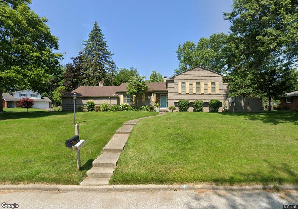
129 Ottekee Dr Perrysburg, OH 43551
Estimated Value: $317,000 - $394,000
4
Beds
2
Baths
1,939
Sq Ft
$182/Sq Ft
Est. Value
About This Home
This home is located at 129 Ottekee Dr, Perrysburg, OH 43551 and is currently estimated at $351,957, approximately $181 per square foot. 129 Ottekee Dr is a home located in Wood County with nearby schools including Fort Meigs Elementary School, Perrysburg Junior High School, and Perrysburg High School.
Ownership History
Date
Name
Owned For
Owner Type
Purchase Details
Closed on
Jun 28, 1996
Sold by
Coy Mary F
Bought by
Kaichin Peter T and Kaichin Analie J
Current Estimated Value
Home Financials for this Owner
Home Financials are based on the most recent Mortgage that was taken out on this home.
Original Mortgage
$130,500
Outstanding Balance
$9,343
Interest Rate
8.13%
Mortgage Type
New Conventional
Estimated Equity
$342,614
Purchase Details
Closed on
Jun 29, 1992
Bought by
Coy Mary Frederick M
Create a Home Valuation Report for This Property
The Home Valuation Report is an in-depth analysis detailing your home's value as well as a comparison with similar homes in the area
Home Values in the Area
Average Home Value in this Area
Purchase History
| Date | Buyer | Sale Price | Title Company |
|---|---|---|---|
| Kaichin Peter T | $163,500 | -- | |
| Coy Mary Frederick M | $137,000 | -- |
Source: Public Records
Mortgage History
| Date | Status | Borrower | Loan Amount |
|---|---|---|---|
| Open | Kaichin Peter T | $130,500 |
Source: Public Records
Tax History Compared to Growth
Tax History
| Year | Tax Paid | Tax Assessment Tax Assessment Total Assessment is a certain percentage of the fair market value that is determined by local assessors to be the total taxable value of land and additions on the property. | Land | Improvement |
|---|---|---|---|---|
| 2024 | $4,590 | $79,310 | $20,125 | $59,185 |
| 2023 | $4,590 | $79,320 | $20,130 | $59,190 |
| 2021 | $3,904 | $62,100 | $15,440 | $46,660 |
| 2020 | $3,884 | $62,100 | $15,440 | $46,660 |
| 2019 | $3,632 | $56,360 | $15,440 | $40,920 |
| 2018 | $3,224 | $56,360 | $15,440 | $40,920 |
| 2017 | $3,203 | $56,360 | $15,440 | $40,920 |
| 2016 | $3,015 | $50,720 | $15,440 | $35,280 |
| 2015 | $3,015 | $50,720 | $15,440 | $35,280 |
| 2014 | $3,041 | $50,720 | $15,440 | $35,280 |
| 2013 | $3,111 | $50,720 | $15,440 | $35,280 |
Source: Public Records
Map
Nearby Homes
- 125 Ottekee Dr
- 26951 Ottekee Dr
- 26835 Mohawk Dr
- 1626 Woodstream Rd
- 2053 Lexington Dr
- 2062 Lexington Dr
- 26802 Fort Meigs Rd
- 13975 Eckel Junction Rd
- 700 Delaware Dr
- 471 Rutledge Ct
- 712 W Harrison St
- 664 Little Creek Dr
- 454 S Ridge Dr
- 670 Ridge Lake Ct
- 948 Joliet Dr
- 0 Brookwoode Rd
- 504 W John St
- 220 W Wayne St
- 234 W Dudley St
- 1380 Brookwoode Rd
- 115 Cranden Dr
- 201 Cranden Dr
- 128 Cranden Dr
- 124 Cranden Dr
- 122 Ottekee Dr
- 132 Cranden Dr
- 120 Cranden Dr
- 111 Cranden Dr
- 121 Ottekee Dr
- 205 Cranden Dr
- 118 Ottekee Dr
- 202 Cranden Dr
- 112 Cranden Dr
- 13716 Otusso Dr
- 13734 Otusso Dr
- 117 Ottekee Dr
- 209 Cranden Dr
- 13698 Otusso Dr
- 13754 Otusso Dr
- 13774 Otusso Dr