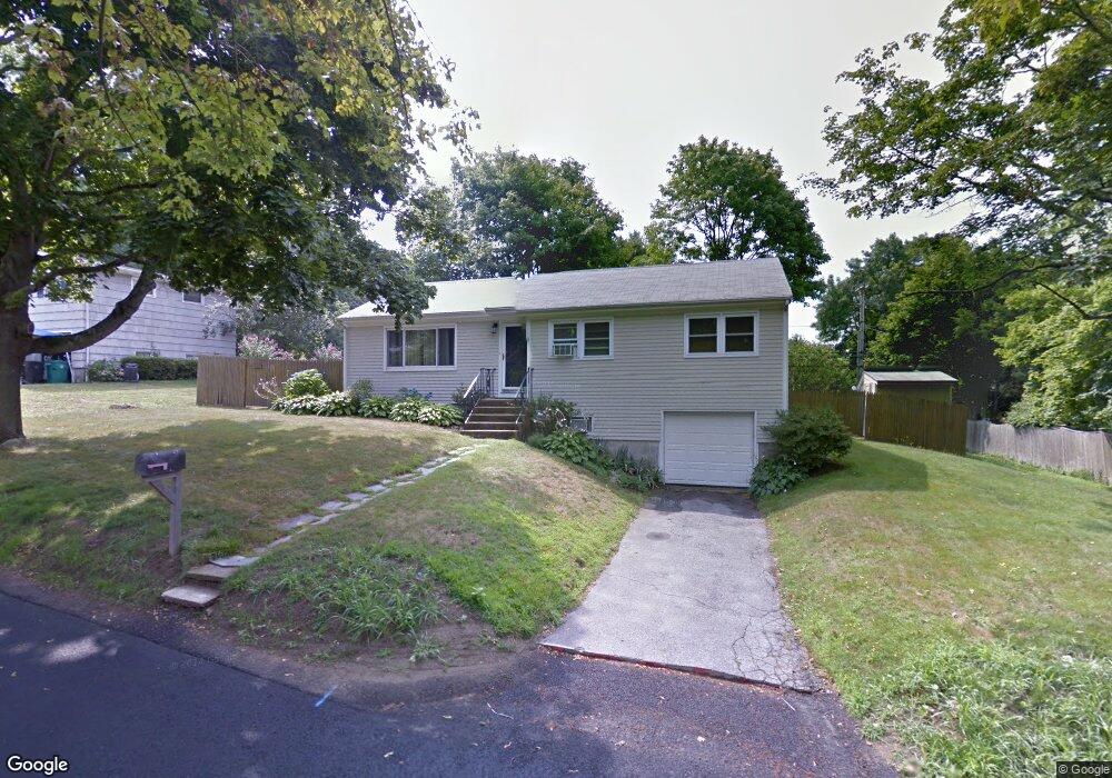
13 Concord Dr Middletown, RI 02842
Estimated Value: $656,804 - $734,000
3
Beds
2
Baths
1,270
Sq Ft
$543/Sq Ft
Est. Value
About This Home
This home is located at 13 Concord Dr, Middletown, RI 02842 and is currently estimated at $689,201, approximately $542 per square foot. 13 Concord Dr is a home located in Newport County with nearby schools including Middletown High School, St Michael's Country Day School, and St George's School.
Ownership History
Date
Name
Owned For
Owner Type
Purchase Details
Closed on
Feb 10, 2011
Sold by
Call David B and Call Lori A
Bought by
Call Lori A
Current Estimated Value
Purchase Details
Closed on
Dec 21, 1995
Sold by
Siebens Karl K
Bought by
Call David B and Call Lori
Home Financials for this Owner
Home Financials are based on the most recent Mortgage that was taken out on this home.
Original Mortgage
$78,000
Interest Rate
7.33%
Create a Home Valuation Report for This Property
The Home Valuation Report is an in-depth analysis detailing your home's value as well as a comparison with similar homes in the area
Home Values in the Area
Average Home Value in this Area
Purchase History
| Date | Buyer | Sale Price | Title Company |
|---|---|---|---|
| Call Lori A | -- | -- | |
| Call David B | $98,000 | -- |
Source: Public Records
Mortgage History
| Date | Status | Borrower | Loan Amount |
|---|---|---|---|
| Previous Owner | Call David B | $71,900 | |
| Previous Owner | Call David B | $78,000 |
Source: Public Records
Tax History Compared to Growth
Tax History
| Year | Tax Paid | Tax Assessment Tax Assessment Total Assessment is a certain percentage of the fair market value that is determined by local assessors to be the total taxable value of land and additions on the property. | Land | Improvement |
|---|---|---|---|---|
| 2025 | $7,258 | $615,600 | $454,900 | $160,700 |
| 2024 | $6,932 | $615,600 | $454,900 | $160,700 |
| 2023 | $4,639 | $368,500 | $244,600 | $123,900 |
| 2022 | $4,429 | $368,500 | $244,600 | $123,900 |
| 2021 | $4,429 | $368,500 | $244,600 | $123,900 |
| 2020 | $4,281 | $311,100 | $187,200 | $123,900 |
| 2018 | $4,278 | $311,100 | $187,200 | $123,900 |
| 2016 | $4,128 | $267,700 | $161,700 | $106,000 |
| 2015 | $4,026 | $267,700 | $161,700 | $106,000 |
| 2014 | $4,116 | $256,100 | $147,000 | $109,100 |
| 2013 | $4,023 | $256,100 | $147,000 | $109,100 |
Source: Public Records
Map
Nearby Homes
- 476 Green End Ave
- 0 Honeyman Ave
- 55 John Clarke Rd Unit 8
- 55 John Clarke Rd Unit 3
- 138 Green End Ave
- 0 Wolcott Ave
- 1 Shangri-La Ln
- 318 Corey Ln
- 310 Corey Ln
- 36 Kay Blvd
- 74 Valley Rd
- 223 Corey Ln
- 117 W Main Rd
- 149 W Main Rd
- 119 Corey Ln
- 6 Wabasso Terrace
- 65 Seascape Ave
- 118 Wolcott Ave
- 67 Linden St
- 5 Elliot Place