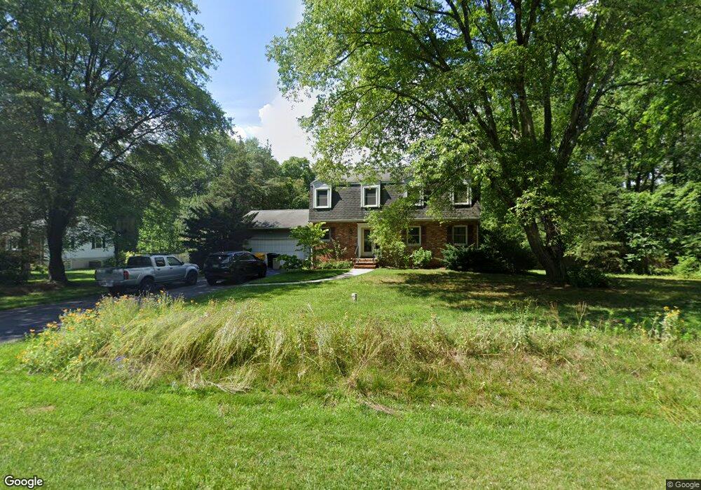
1300 Shawnee Ct Millersville, MD 21108
Estimated Value: $519,000 - $694,664
--
Bed
3
Baths
2,204
Sq Ft
$288/Sq Ft
Est. Value
About This Home
This home is located at 1300 Shawnee Ct, Millersville, MD 21108 and is currently estimated at $635,166, approximately $288 per square foot. 1300 Shawnee Ct is a home located in Anne Arundel County with nearby schools including Millersville Elementary School, Old Mill High School, and Guidepost Montessori at Gambrills.
Ownership History
Date
Name
Owned For
Owner Type
Purchase Details
Closed on
Jan 20, 2009
Sold by
Hungelmann Dain
Bought by
Love Amy E
Current Estimated Value
Purchase Details
Closed on
Jan 14, 2009
Sold by
Hungelmann Dain
Bought by
Love Amy E
Purchase Details
Closed on
Oct 19, 2000
Sold by
Kim Paul E
Bought by
Love Iii Cornelius R and Love Amy E
Purchase Details
Closed on
Apr 22, 1999
Sold by
Kim Bong O
Bought by
Kim Paul E and Kim Jeong Soon
Purchase Details
Closed on
Mar 10, 1999
Sold by
Kim Jeong Sook
Bought by
Kim Bong O
Purchase Details
Closed on
Jun 11, 1998
Sold by
Kim Paul E
Bought by
Kim Jeong Sook
Create a Home Valuation Report for This Property
The Home Valuation Report is an in-depth analysis detailing your home's value as well as a comparison with similar homes in the area
Home Values in the Area
Average Home Value in this Area
Purchase History
| Date | Buyer | Sale Price | Title Company |
|---|---|---|---|
| Love Amy E | -- | -- | |
| Love Amy E | -- | -- | |
| Love Iii Cornelius R | $232,500 | -- | |
| Kim Paul E | -- | -- | |
| Kim Bong O | -- | -- | |
| Kim Jeong Sook | $150,000 | -- |
Source: Public Records
Mortgage History
| Date | Status | Borrower | Loan Amount |
|---|---|---|---|
| Closed | Kim Jeong Sook | -- |
Source: Public Records
Tax History Compared to Growth
Tax History
| Year | Tax Paid | Tax Assessment Tax Assessment Total Assessment is a certain percentage of the fair market value that is determined by local assessors to be the total taxable value of land and additions on the property. | Land | Improvement |
|---|---|---|---|---|
| 2025 | $4,228 | $525,700 | $265,000 | $260,700 |
| 2024 | $4,228 | $500,900 | $0 | $0 |
| 2023 | $3,472 | $476,100 | $0 | $0 |
| 2022 | $3,827 | $451,300 | $225,000 | $226,300 |
| 2021 | $7,527 | $442,100 | $0 | $0 |
| 2020 | $3,660 | $432,900 | $0 | $0 |
| 2019 | $3,601 | $423,700 | $175,000 | $248,700 |
| 2018 | $4,175 | $411,733 | $0 | $0 |
| 2017 | $3,390 | $399,767 | $0 | $0 |
| 2016 | -- | $387,800 | $0 | $0 |
| 2015 | -- | $387,800 | $0 | $0 |
| 2014 | -- | $387,800 | $0 | $0 |
Source: Public Records
Map
Nearby Homes
- 1220 Indian Landing Rd
- 771 Generals Hwy
- 1610 Hog Farm Rd
- 1400 Lower View Ct
- 30 Highland Dr
- 983 Wayside Dr
- 1013 Waterbury Heights Dr
- 397 Charles Hall Dr
- 1080 Generals Hwy
- 605, 607 Crain Hwy N
- 1184 Tanager Dr
- 1759 Daisey Ct
- 927 Heatherfield Ln
- 610 Echo Cove Dr
- 1158 Blue Bird Ln
- 626 Evergreen Rd
- 1404 Cotton Ct
- 1270 Dorothy Rd
- 1458 Wilderness Ridge Trail
- 820 Annapolis Rd
- 1304 Shawnee Ct
- 1301 Shawnee Ct
- 880 Generals Hwy
- 1305 Shawnee Ct
- 887 Generals Hwy
- 1308 Shawnee Ct
- 878 Generals Hwy
- 1303 Shawnee Ct
- 897 Generals Hwy
- 874 Generals Hwy
- 1312 Shawnee Ct
- 872 Generals Hwy
- 1313 Shawnee Ct
- 1309 Shawnee Ct
- 1316 Shawnee Ct
- 1311 Shawnee Ct
- 868 Generals Hwy
- 858 Generals Hwy
- 867 Generals Hwy
- 921 Generals Hwy