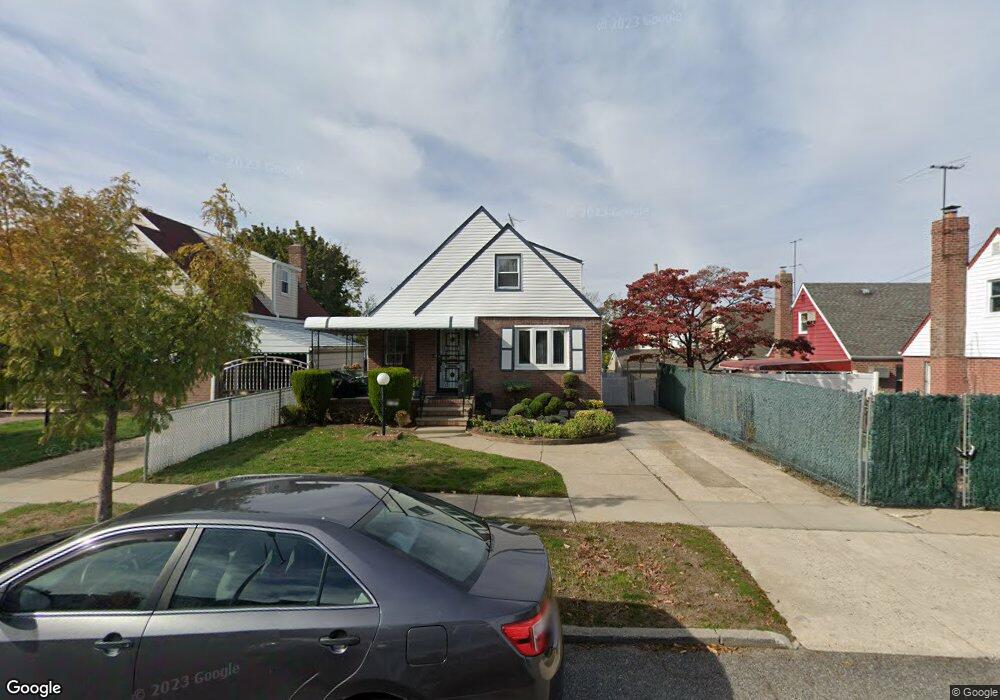
13014 217th St Springfield Gardens, NY 11413
Laurelton NeighborhoodEstimated Value: $653,810 - $753,000
--
Bed
--
Bath
1,126
Sq Ft
$625/Sq Ft
Est. Value
About This Home
This home is located at 13014 217th St, Springfield Gardens, NY 11413 and is currently estimated at $703,453, approximately $624 per square foot. 13014 217th St is a home located in Queens County with nearby schools including P.S. 132 - Ralph Bunche, Is 59 Springfield Gardens, and Success Academy Springfield Gardens.
Ownership History
Date
Name
Owned For
Owner Type
Purchase Details
Closed on
Jan 19, 2010
Sold by
Brooks Shirley J
Bought by
Brooks Barry N and Brooks Shirley J
Current Estimated Value
Purchase Details
Closed on
Oct 31, 1997
Sold by
Brooks Uneal and Brooks Shirley J
Bought by
Brooks Uneal and Brooks Shirley J
Create a Home Valuation Report for This Property
The Home Valuation Report is an in-depth analysis detailing your home's value as well as a comparison with similar homes in the area
Home Values in the Area
Average Home Value in this Area
Purchase History
| Date | Buyer | Sale Price | Title Company |
|---|---|---|---|
| Brooks Barry N | -- | -- | |
| Brooks Barry N | -- | -- | |
| Brooks Uneal | -- | First American Title Ins Co | |
| Brooks Uneal | -- | First American Title Ins Co |
Source: Public Records
Tax History Compared to Growth
Tax History
| Year | Tax Paid | Tax Assessment Tax Assessment Total Assessment is a certain percentage of the fair market value that is determined by local assessors to be the total taxable value of land and additions on the property. | Land | Improvement |
|---|---|---|---|---|
| 2025 | $5,197 | $31,104 | $8,743 | $22,361 |
| 2024 | $5,209 | $30,154 | $9,590 | $20,564 |
| 2023 | $5,045 | $29,123 | $9,421 | $19,702 |
| 2022 | $4,623 | $37,500 | $12,480 | $25,020 |
| 2021 | $4,553 | $31,080 | $12,480 | $18,600 |
| 2020 | $4,581 | $29,460 | $12,480 | $16,980 |
| 2019 | $4,361 | $28,980 | $12,480 | $16,500 |
| 2018 | $4,063 | $24,269 | $11,850 | $12,419 |
| 2017 | $4,075 | $22,896 | $11,788 | $11,108 |
| 2016 | $3,734 | $22,896 | $11,788 | $11,108 |
| 2015 | $2,414 | $21,720 | $13,860 | $7,860 |
| 2014 | $2,414 | $20,940 | $13,860 | $7,080 |
Source: Public Records
Map
Nearby Homes
- 13024 Springfield Blvd
- 130-25 217th St
- 19332 Williamson Ave
- 13049 217th St
- 122-52 Springfield Blvd
- 192-17 Williamson Ave
- 194-01 Nashville Blvd
- 19401 Nashville Blvd
- 21827 130th Ave
- 19115 Williamson Ave
- 21924 130th Dr
- 194-09 122nd Ave
- 121-17 196th St
- 21917 132nd Rd
- 130-45 220th St
- 121-16 198th St
- 121-11 195th St
- 121-9 195th St
- 12105 196th St
- 12512 Nepton St
- 13016 217th St
- 130-18 217th St
- 21616 130th Ave
- 130-26 217th St
- 21622 130th Ave
- 21612 130th Ave
- 13018 217th St
- 21608 130th Ave
- 13009 Springfield Blvd
- 13022 217th St
- 13009 Springfield Blvd
- 21604 130th Ave
- 13019 Springfield Blvd
- 130-19 Springfield Blvd
- 217-04 130th Ave
- 21704 130th Ave
- 13026 217th St
- 217-16 130th Ave
- 13015 217th St
- 13023 Springfield Blvd