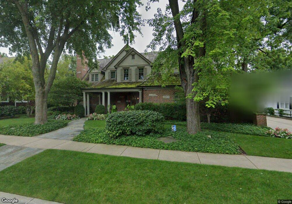
131 Homewood Ave Libertyville, IL 60048
Estimated Value: $1,925,162 - $2,424,000
4
Beds
7
Baths
5,500
Sq Ft
$379/Sq Ft
Est. Value
About This Home
This home is located at 131 Homewood Ave, Libertyville, IL 60048 and is currently estimated at $2,084,041, approximately $378 per square foot. 131 Homewood Ave is a home located in Lake County with nearby schools including Butterfield School, Highland Middle School, and Libertyville High School.
Ownership History
Date
Name
Owned For
Owner Type
Purchase Details
Closed on
Jun 25, 2015
Sold by
The P Douglas Cayce 2012 Revocable Trust
Bought by
The Allyson D Cayce 2012 Revocable Trust
Current Estimated Value
Home Financials for this Owner
Home Financials are based on the most recent Mortgage that was taken out on this home.
Original Mortgage
$795,679
Outstanding Balance
$512,403
Interest Rate
1.87%
Mortgage Type
Adjustable Rate Mortgage/ARM
Estimated Equity
$1,571,638
Purchase Details
Closed on
Feb 27, 2013
Sold by
Cayce P Douglas and Cayce Allyson
Bought by
Cayce P Douglas and Cayce Allyson D
Purchase Details
Closed on
Jun 10, 2011
Sold by
Ghp Holdings Llc
Bought by
Cayce P Douglas and Cayce Allyson
Home Financials for this Owner
Home Financials are based on the most recent Mortgage that was taken out on this home.
Original Mortgage
$417,000
Interest Rate
4.56%
Mortgage Type
New Conventional
Purchase Details
Closed on
Dec 3, 2004
Sold by
Atkinson Builders Llc
Bought by
Ghp Holdings Llc
Home Financials for this Owner
Home Financials are based on the most recent Mortgage that was taken out on this home.
Original Mortgage
$453,750
Interest Rate
4.75%
Mortgage Type
Purchase Money Mortgage
Purchase Details
Closed on
Nov 11, 2004
Sold by
Cannon John D and The John D Cannon Jr Trust #1
Bought by
Atkinson Builders Llc
Home Financials for this Owner
Home Financials are based on the most recent Mortgage that was taken out on this home.
Original Mortgage
$453,750
Interest Rate
4.75%
Mortgage Type
Purchase Money Mortgage
Purchase Details
Closed on
Aug 26, 2004
Sold by
Cannon John D and Cannon Marian O
Bought by
Cannon John D and Cannon Marian O
Purchase Details
Closed on
Jun 27, 1994
Sold by
Ahrens Carol Jane and Ahrens Richard James
Bought by
Cannon John D and Cannon Marian O
Home Financials for this Owner
Home Financials are based on the most recent Mortgage that was taken out on this home.
Original Mortgage
$141,600
Interest Rate
8.61%
Create a Home Valuation Report for This Property
The Home Valuation Report is an in-depth analysis detailing your home's value as well as a comparison with similar homes in the area
Home Values in the Area
Average Home Value in this Area
Purchase History
| Date | Buyer | Sale Price | Title Company |
|---|---|---|---|
| The Allyson D Cayce 2012 Revocable Trust | -- | None Available | |
| Cayce P Douglas | -- | None Available | |
| Cayce P Douglas | $1,325,000 | Chicago Title Insurance Co | |
| Ghp Holdings Llc | $755,000 | -- | |
| Atkinson Builders Llc | $605,000 | First American Title | |
| Cannon John D | -- | -- | |
| Cannon John D | $177,000 | -- |
Source: Public Records
Mortgage History
| Date | Status | Borrower | Loan Amount |
|---|---|---|---|
| Open | The Allyson D Cayce 2012 Revocable Trust | $795,679 | |
| Closed | Cayce P Douglas | $417,000 | |
| Previous Owner | Atkinson Builders Llc | $453,750 | |
| Previous Owner | Cannon John D | $141,600 |
Source: Public Records
Tax History Compared to Growth
Tax History
| Year | Tax Paid | Tax Assessment Tax Assessment Total Assessment is a certain percentage of the fair market value that is determined by local assessors to be the total taxable value of land and additions on the property. | Land | Improvement |
|---|---|---|---|---|
| 2024 | $40,778 | $557,653 | $154,141 | $403,512 |
| 2023 | $33,645 | $514,345 | $142,170 | $372,175 |
| 2022 | $33,645 | $426,680 | $136,649 | $290,031 |
| 2021 | $32,408 | $417,495 | $133,707 | $283,788 |
| 2020 | $38,628 | $506,748 | $131,459 | $375,289 |
| 2019 | $37,664 | $501,929 | $130,209 | $371,720 |
| 2018 | $37,878 | $514,583 | $135,571 | $379,012 |
| 2017 | $36,870 | $498,337 | $131,291 | $367,046 |
| 2016 | $35,700 | $472,492 | $124,482 | $348,010 |
| 2015 | $35,447 | $478,535 | $116,349 | $362,186 |
| 2014 | $35,409 | $449,633 | $109,322 | $340,311 |
| 2012 | $33,713 | $436,090 | $106,029 | $330,061 |
Source: Public Records
Map
Nearby Homes
- 551 W Park Ave Unit E
- 420 W Cook Ave
- 505 Lange Ct
- 212 Elm Ct
- 308 Mckinley Ave
- 423 Ames St
- 1754 Glenmore Rd
- 0 Ames St
- 217 E Church St
- 533 Drake St
- 619 Parkside Ct
- 212 W Ellis Ave
- 426 S Milwaukee Ave
- 616 Parkside Ct
- 662 Parkside Ct
- 208 W Ellis Ave
- 694 Parkside Ct
- 204 W Ellis Ave
- 922 N Milwaukee Ave Unit A
- 224 Newberry Ave
- 139 Homewood Ave
- 125 Homewood Ave
- 121 Homewood Ave
- 145 Homewood Ave
- 130 Sunset Dr
- 134 Sunset Dr
- 202 Sunset Dr
- 126 Sunset Dr
- 119 Homewood Ave
- 130 Homewood Ave
- 208 Sunset Dr
- 136 Homewood Ave
- 126 Homewood Ave
- 120 Sunset Dr
- 140 Homewood Ave
- 151 Homewood Ave
- 111 Homewood Ave
- 120 Homewood Ave
- 214 Sunset Dr
- 146 Homewood Ave